METAR & TAF KPTS
Current METAR
Observed 22:15Z
KPTS 272215Z AUTO 20011KT 10SM CLR 37/21 A2982 RMK AO2
- Wind
- 200° @ 11 kt
- Visibility
- 10 SM
- Temp / Dew
- 37°C / 21°C
- Altimeter
- 29.82 inHg
- Clouds
- CLR
- Density alt
- 3,937 ft
- Ceiling
- Unlimited
- Rules
- VFR
Airport info & contacts
Manager on record, flight service, ARTCC, attendance schedule and pattern altitude — published by the FAA and refreshed every 28 days.
Location
- From city
- 3 NM NW
- VFR sectional
- KANSAS CITY
- ARTCC
- ZKC · KANSAS CITY
- NOTAM facility
- ICT (NOTAM-D)
Airport manager
- Name
- BILL PYLE
- Phone
- 620-231-5760
- Address
- 3510 ARPT DR, PITTSBURG KS 66762
Flight service · Hours
- FSS ICT
- WICHITA1-800-WX-BRIEF
- Attendance
- MON-FRI · 0700-1700
- SAT-SUN · 0800-1600
Frequencies
Tap any row to copy the frequency to your clipboard.
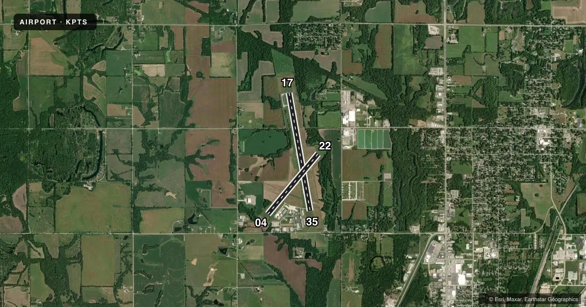
Runways & pattern
Full pagePattern entry · RWY 22
LEFT TRAFFIC| Runway | Heading (°M) | Length | Surface | Traffic |
|---|---|---|---|---|
| 17/35 | 168° / 348° | 6,100 ft | ASPH | Standard L |
| 04/22Favored | 38° / 218° | 4,000 ft | ASPH | Standard L |
Runway end performance
| End | TORA | TODA | ASDA | LDA | VGSI | Approach lights | Obstruction |
|---|---|---|---|---|---|---|---|
| 17 | — | — | — | — | PAPI 4-box left(3°) | — | 46', trees, 1136' from thr, 195' R of cntrln, slope 20 |
| 35 | — | — | — | — | PAPI 4-box left(3°) | — | 53', trees, 1230' from thr, 396' R of cntrln, slope 19 |
| 04 | — | — | — | — | PAPI 4-box left(3°) | — | 44', trees, 450' from thr, 148' R of cntrln, slope 5 |
| 22 | — | — | — | — | PAPI 4-box left(3.8°) | — | 47', trees, 377' from thr, 204' R of cntrln, slope 3 |
Declared distances in feet. TORA = takeoff run available, TODA = takeoff distance, ASDA = accelerate-stop, LDA = landing distance.
Airport sketch
Runways drawn to scale from FAA survey coordinates, rendered over satellite imagery. Not for navigation.
Approaches & charts
Services on the field
Fuel grades, oxygen, maintenance, ramp storage and lighting — as declared to the FAA by the airport operator.
Fuel & services
- Fuel
- 100LLA
- Oxygen (bottled)
- HIGH/LOW
- Oxygen (bulk)
- Not available
- Airframe repair
- Major
- Power plant repair
- Major
- Other services
- AMB,INSTR,RNTL
Ramp & ground
- Transient storage
- Tie-down
- Hangar
- Landing fee
- No fee published
- Customs
- Not available
- Lighting schedule
- SEE RMK
- Beacon schedule
- SS-SR
- Beacon
- White / Green (civil land)(WG)
- Wind indicator
- Lighted
- Segmented circle
- No
Fuel & FBOs
Cheapest 100LL and Jet A on the field and nearby. Always confirm with the FBO before taxi.
Airport notes
Surface conditions, obstructions, local procedures, lighting outages and other notes published with each FAA cycle.
General notes
- BIRDS ON & INVOF ARPT.
- FOR CD IF UNA TO CTC ON FSS FREQ, CTC KANSAS CITY ARTCC AT 913-254-8508.
Lighting notes
- ACTVT MIRL RWYS 04/22 & 17/35; PAPI & REIL RWYS 17, 35, 04 & 22 - CTAF.
Approach & departure obstructions
- 17MKGS FADED.
- 35MKGS FADED.
VFR map & nearby airports
VFR sectional. Tap any ICAO chip to open that airport.
Key facts · KPTS
Answer card- ICAO
- KPTS
- Name
- ATKINSON MUNI
- Location
- PITTSBURG, KANSAS
- Elevation
- 946.2 ft MSL
- Traffic pattern altitude
- 1,946.2 ft MSL (1,000 AGL)
- Control tower
- Non-towered (use CTAF)
- Total runways
- 2
- Longest runway
- 17/35 · 6,100 ft
- Published ILS approaches
- 0
- Published frequencies
- 2
- Magnetic variation
- 2°
- Current flight rules
- VFR
- Current wind
- 200° at 11 kt
- Favored runway now
- RWY 22
Atkinson Muni Airport is in Pittsburg, Kansas. The field elevation is 946.2 ft MSL. KPTS has two asphalt runways. The longest is runway 17/35 at 6,100 ft. Runway 04/22 is 4,000 ft.
There is no control tower. CTAF and UNICOM are both 123.0. No ILS approaches are published here. Pattern altitude is not published, so a light piston pilot should plan for the standard 1,000 ft AGL pattern unless the current Chart Supplement says otherwise. The airport sits in southeast Kansas, so expect a non-towered traffic flow with local calls on CTAF. Birds are reported on and near the airport. That is worth keeping in mind on departure and arrival.
Atkinson Municipal Airport is the on-field FBO. It carries AVGAS 100LL and Jet A. The phone number is (620) 231-5760. Published remarks also note that runway 17 and runway 35 have faded markings. Medium intensity runway lights are available on both runways. PAPI and REIL are available on 17, 35, 04 and 22. If you need clearance delivery and cannot raise Flight Service, Kansas City Center is listed in the remarks. Check the current FAA Chart Supplement for any noise or operational changes before you go.