METAR & TAF KFSK
Current METAR
Observed 18:35Z
KFSK 271835Z AUTO 21010KT 10SM CLR 37/22 A2986 RMK AO2 T03700219
- Wind
- 210° @ 10 kt
- Visibility
- 10 SM
- Temp / Dew
- 37°C / 22°C
- Altimeter
- 29.86 inHg
- Clouds
- CLR
- Density alt
- 3,853 ft
- Ceiling
- Unlimited
- Rules
- VFR
Airport info & contacts
Manager on record, flight service, ARTCC, attendance schedule and pattern altitude — published by the FAA and refreshed every 28 days.
Location
- From city
- 4 NM SW
- VFR sectional
- KANSAS CITY
- ARTCC
- ZKC · KANSAS CITY
- NOTAM facility
- ICT (NOTAM-D)
Airport manager
- Name
- SETH SIMPSON
- Phone
- 620-223-5490
- Address
- 1869 INDIAN RD., P.O. BOX 151, FORT SCOTT KS 66701
Flight service · Hours
- FSS ICT
- WICHITA1-800-WX-BRIEF
- Attendance
- MON-SAT · 0800-1700
Frequencies
Tap any row to copy the frequency to your clipboard.
Runways & pattern
Full pagePattern entry · RWY 18
LEFT TRAFFICRunway end performance
| End | TORA | TODA | ASDA | LDA | VGSI | Approach lights | Obstruction |
|---|---|---|---|---|---|---|---|
| 18 | — | — | — | — | VASI 4-box left(3°) | — | 20', trees, 250' from thr, 215' R of cntrln, slope 2 |
| 36 | — | — | — | — | PAPI 2-box left(3°) | — | 55', tree, 1403' from thr, 220' R of cntrln, slope 21 |
Declared distances in feet. TORA = takeoff run available, TODA = takeoff distance, ASDA = accelerate-stop, LDA = landing distance.
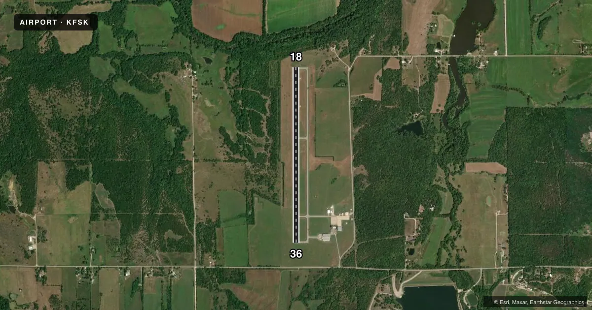
Airport sketch
Runways drawn to scale from FAA survey coordinates, rendered over satellite imagery. Not for navigation.
Approaches & charts
Services on the field
Fuel grades, oxygen, maintenance, ramp storage and lighting — as declared to the FAA by the airport operator.
Fuel & services
- Fuel
- 100LLA1+
- Oxygen (bottled)
- Not available
- Oxygen (bulk)
- Not available
- Airframe repair
- Not available
- Power plant repair
- Not available
- Other services
- INSTR
Ramp & ground
- Transient storage
- Tie-down
- Hangar
- Landing fee
- No fee published
- Customs
- Not available
- Lighting schedule
- SEE RMK
- Beacon schedule
- SS-SR
- Beacon
- White / Green (civil land)(WG)
- Wind indicator
- Lighted
Fuel & FBOs
Cheapest 100LL and Jet A on the field and nearby. Always confirm with the FBO before taxi.
Airport notes
Surface conditions, obstructions, local procedures, lighting outages and other notes published with each FAA cycle.
General notes
- DEER FENCE AROUND AIRPORT PERIMETER.
- GROUND DROPS RAPIDLY 250' FROM RWY 18 END.
- FOR CD CTC KANSAS CITY ARTCC AT 913-254-8508.
Lighting notes
- ACTVT MIRL RY 18/36; VASI RY 18; PAPI RY 36 & REIL RYS 18 & 36 - CTAF.
Other notes
- THIS AIRPORT HAS BEEN SURVEYED BY THE NATIONAL GEODETIC SURVEY.
- CONDL-PRVD THE APCH TO RWY 17 IS MAINTAINED FOR A MINIMUM 34:1 GLIDE SLOPE AND RWY 36 FOR A MINIMUM 20:1 GLIDE SLOPE AND THE TRANSITIONAL SURFACE BE MAINTAINED FOR A 7:1 SLOPE.
VFR map & nearby airports
VFR sectional. Tap any ICAO chip to open that airport.
Key facts · KFSK
Answer card- ICAO
- KFSK
- Name
- FORT SCOTT MUNI
- Location
- FORT SCOTT, KANSAS
- Elevation
- 918 ft MSL
- Traffic pattern altitude
- 1,918 ft MSL (1,000 AGL)
- Control tower
- Non-towered (use CTAF)
- Total runways
- 1
- Longest runway
- 18/36 · 4,403 ft
- Published ILS approaches
- 0
- Published frequencies
- 2
- Magnetic variation
- 4°
- Current flight rules
- VFR
- Current wind
- 210° at 10 kt
- Favored runway now
- RWY 18
Fort Scott Muni sits in Fort Scott, Kansas. Field elevation is 918 ft MSL. The airport has one runway, 18/36, which is 4,403 ft long and asphalt. This is a non-towered field. Use CTAF 122.8 for traffic calls. No ILS approaches are published here.
The pattern altitude is not published. Use the standard 1,000 ft AGL pattern unless the current Chart Supplement or local procedures say otherwise. The field has medium intensity runway lights on 18/36. Runway 18 has VASI. Runway 36 has PAPI. REILs are on both runway ends. The airport also has a deer fence around the perimeter. The ground drops rapidly about 250 ft from the runway 18 end, so plan your departure and arrival with that in mind.
Fort Scott Municipal Airport is the on-field FBO. It carries AVGAS 100LL and Jet A. Call the FBO directly at (620) 223-5490 for current services. For clearance delivery, contact Kansas City ARTCC at 913-254-8508. Pilots should also note the published surface and approach slope remarks. Check the current FAA Chart Supplement before flying in if you need the latest operational details.