METAR & TAF K68
K68 does not publish a METAR.
Showing the nearest reporting station: KOWI (OTTAWA MUNI) · 15.8 NM away. Conditions at K68 may differ.
METAR · KOWI
Observed 23:10Z
KOWI 272310Z AUTO 20007KT 10SM CLR 37/24 A2977 RMK A01
- Wind
- 200° @ 7 kt
- Visibility
- 10 SM
- Temp / Dew
- 37°C / 24°C
- Altimeter
- 29.77 inHg
- Clouds
- CLR
- Density alt
- 4,052 ft
- Ceiling
- Unlimited
- Rules
- VFR
Airport info & contacts
Manager on record, flight service, ARTCC, attendance schedule and pattern altitude — published by the FAA and refreshed every 28 days.
Location
- From city
- 2 NM E
- VFR sectional
- KANSAS CITY
- ARTCC
- ZKC · KANSAS CITY
- NOTAM facility
- ICT (NOTAM-D)
Airport manager
- Name
- PAT SCHETTLER
- Phone
- 785-448-6931
- Address
- 1202 E 4TH ST ROAD, GARNETT KS 66032
Flight service · Hours
- FSS ICT
- WICHITA1-800-WX-BRIEF
- Attendance
- SAT - SUN · ON CALL
- MON - FRI · 0800 - 1700
Frequencies
Tap any row to copy the frequency to your clipboard.
Runways & pattern
Full pagePattern entry · RWY 19
LEFT TRAFFICRunway end performance
| End | TORA | TODA | ASDA | LDA | VGSI | Approach lights | Obstruction |
|---|---|---|---|---|---|---|---|
| 19 | — | — | — | — | — | — | 34', trees, 628' from thr, 46' R of cntrln, slope 12 |
Declared distances in feet. TORA = takeoff run available, TODA = takeoff distance, ASDA = accelerate-stop, LDA = landing distance.
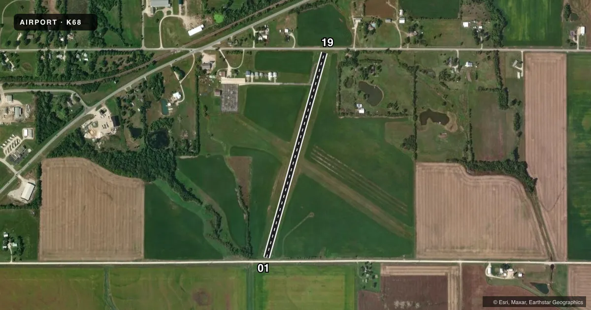
Airport sketch
Runways drawn to scale from FAA survey coordinates, rendered over satellite imagery. Not for navigation.
Approaches & charts
Services on the field
Fuel grades, oxygen, maintenance, ramp storage and lighting — as declared to the FAA by the airport operator.
Fuel & services
- Fuel
- 100LL
- Oxygen (bottled)
- Not available
- Oxygen (bulk)
- Not available
- Airframe repair
- Not available
- Power plant repair
- Not available
- Other services
- AGRI,INSTR
Ramp & ground
- Transient storage
- Tie-down
- Landing fee
- No fee published
- Customs
- Not available
- Beacon schedule
- SS-SR
- Beacon
- White / Green (civil land)(WG)
- Wind indicator
- Lighted
- Segmented circle
- No
Fuel & FBOs
Cheapest 100LL and Jet A on the field and nearby. Always confirm with the FBO before taxi.
Airport notes
Surface conditions, obstructions, local procedures, lighting outages and other notes published with each FAA cycle.
General notes
- IF EMERG EXIST CALL 911 OR NIGHT OR EMERG 785-448-8067; FBO PHONE NUMBER 785-448-6931.
- FOR CD CTC KANSAS CITY ARTCC AT 913-254-8508.
Fuel notes
- 100LLFUEL AVBL 24HRS WITH CREDIT CARD.
Approach & departure obstructions
- 01+15 ROAD 35 FT FROM AER 01.
- 19+15 FT ROAD 90 FT FM RY END.
- 01RY 01/19 PVMT ENDS MKD WITH YELLOW & WHITE PANELS.
- 19APCH SLOPE TO DSPLCD THLD 15:1 (ROAD).
Other notes
- SEGMENTED CIRCLE NOT AVBL.
- 1FOR ATTENDANT ON SAT & SUN CALL (785) 448-6931 OR (785) 448-8067.
- MANAGERARPT OFC DURG THE DAY 785-448-6931.
VFR map & nearby airports
VFR sectional. Tap any ICAO chip to open that airport.
Key facts · K68
Answer card- ICAO
- K68
- Name
- GARNETT MUNI
- Location
- GARNETT, KANSAS
- Elevation
- 988.6 ft MSL
- Traffic pattern altitude
- 1,988.6 ft MSL (1,000 AGL)
- Control tower
- Non-towered (use CTAF)
- Total runways
- 1
- Longest runway
- 01/19 · 2,653 ft
- Published ILS approaches
- 0
- Published frequencies
- 2
- Magnetic variation
- 5°
- Current flight rules
- VFR
- Current wind
- 200° at 7 kt
- Favored runway now
- RWY 19
Garnett Muni sits in Garnett, Kansas. The field elevation is 988.6 ft MSL. It has one runway, 01/19, which is 2,653 ft long and asphalt. There is no control tower. CTAF and UNICOM are both 122.8. No ILS approaches are published here.
Pattern altitude is not published. Use standard 1,000 ft AGL for light piston operations unless the current Chart Supplement says otherwise. That puts the pattern at about 1,989 ft MSL based on the listed field elevation. The airport is small, so expect self-announce traffic and keep a sharp scan on CTAF.
Garnett Municipal Airport is the on-field FBO. It carries AVGAS 100LL. Fuel is available 24 hours with credit card. The published remarks also note that the runway 01/19 pavement ends are marked with yellow and white panels. There is a road close to each runway end, including one near runway 19 and one near runway 01. That makes the departure and landing picture worth a careful look on a first visit. The segmented circle is not available, so do not rely on that for pattern orientation. For clearance delivery, contact Kansas City ARTCC. If you need the airport office or attendant, call ahead before arrival.