METAR & TAF 39K
39K does not publish a METAR.
Showing the nearest reporting station: KFOE (TOPEKA RGNL) · 15.6 NM away. Conditions at 39K may differ.
METAR · KFOE
Observed 15:53Z
KFOE 271553Z 20010KT 10SM CLR 32/22 A2982 RMK AO2 SLP083 T03220222 $
- Wind
- 200° @ 10 kt
- Visibility
- 10 SM
- Temp / Dew
- 32°C / 22°C
- Altimeter
- 29.82 inHg
- Clouds
- CLR
- Density alt
- 3,468 ft
- Ceiling
- Unlimited
- Rules
- VFR
Airport info & contacts
Manager on record, flight service, ARTCC, attendance schedule and pattern altitude — published by the FAA and refreshed every 28 days.
Location
- From city
- 5 NM N
- VFR sectional
- KANSAS CITY
- ARTCC
- ZKC · KANSAS CITY
- NOTAM facility
- ICT (NOTAM-D)
Airport manager
- Name
- DANIEL SNIDER
- Phone
- 785-554-3667
- Address
- 6420 SE STUBBS RD, BERRYTON KS 66409
Flight service · Hours
- FSS ICT
- WICHITA1-800-WX-BRIEF
- Attendance
- Unattended
Frequencies
Tap any row to copy the frequency to your clipboard.
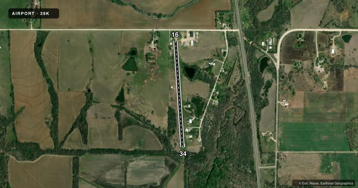
Runways & pattern
Full pagePattern entry · RWY 16
LEFT TRAFFICRunway end performance
| End | TORA | TODA | ASDA | LDA | VGSI | Approach lights | Obstruction |
|---|---|---|---|---|---|---|---|
| 16 | — | — | — | — | — | — | 13', road, 201' from thr, 87' R of cntrln, slope 1 |
| 34 | — | — | — | — | — | — | 27', trees, 221' from thr, 66' R of cntrln, slope 0 |
Declared distances in feet. TORA = takeoff run available, TODA = takeoff distance, ASDA = accelerate-stop, LDA = landing distance.
Airport sketch
Runways drawn to scale from FAA survey coordinates, rendered over satellite imagery. Not for navigation.
Approaches & charts
Services on the field
Fuel grades, oxygen, maintenance, ramp storage and lighting — as declared to the FAA by the airport operator.
Fuel & services
- Fuel
- Not available
- Airframe repair
- Not available
- Power plant repair
- Not available
Ramp & ground
- Transient storage
- Not published
- Landing fee
- No fee published
- Wind indicator
- Yes
- Segmented circle
- No
Fuel & FBOs
Cheapest 100LL and Jet A on the field and nearby. Always confirm with the FBO before taxi.
Airport notes
Surface conditions, obstructions, local procedures, lighting outages and other notes published with each FAA cycle.
General notes
- ULTRALIGHT ACTVTY ON AND INVOF ARPT.
- ARPT CLSD SS-SR INDEFLY.
- FOR TIE DOWN BRING OWN ROPE & ANCHORS.
- LINE OF SIGHT BTN RY ENDS OBSTRUCTED.
- FOR CD CTC KANSAS CITY ARTCC AT 913-254-8508.
Approach & departure obstructions
- 16+13 RD 180 FT FM RWY END.
- 1630 FT HIGH NUMBERS. CL STRIPES 30 FT LONG WITH 30 FT SPACING.
- 3430 FT HIGH NUMBERS. CL STRIPES 30 FT LONG WITH 30 FT SPACING.
- 16HANGARS BOTH SIDES OF RY.
Other notes
- MANAGEROR 785-233-1688.
VFR map & nearby airports
VFR sectional. Tap any ICAO chip to open that airport.
Key facts · 39K
Answer card- ICAO
- 39K
- Name
- DRAGOON CREEK
- Location
- LYNDON, KANSAS
- Elevation
- 1,052 ft MSL
- Traffic pattern altitude
- 2,052 ft MSL (1,000 AGL)
- Control tower
- Non-towered (use CTAF)
- Total runways
- 1
- Longest runway
- 16/34 · 2,170 ft
- Published ILS approaches
- 0
- Published frequencies
- 1
- Magnetic variation
- 6°
- Current flight rules
- VFR
- Current wind
- 200° at 10 kt
- Favored runway now
- RWY 16
Dragoon Creek Airport sits near Lyndon, Kansas. Field elevation is 1,052 ft MSL. The airport has one runway. Runway 16/34 is 2,170 ft long and asphalt. There is no control tower. CTAF is 122.9. No ILS approaches are published.
Pattern altitude is not published. Use 1,000 ft AGL as the standard light piston pattern reference unless the current Chart Supplement says otherwise. That puts the pattern at about 2,052 ft MSL based on the field elevation, but verify before you fly. The airport is closed from sunset to sunrise indefinitely. Plan daylight operations only.
Published remarks matter here. Hangars sit on both sides of the runway. Line of sight between runway ends is obstructed. Runway 16 and runway 34 both have 30-foot-high numbers. Centerline stripes are 30 feet long with 30 feet spacing. There is also a road about 180 ft from the runway end on the 16 side. Ultralight activity occurs on and near the airport. For tie-down, bring your own rope and anchors. For clearance delivery, contact Kansas City ARTCC at 913-254-8508. No on-field FBOs are listed, so contact the airport operator directly or call the field on CTAF for current services before arrival.