METAR & TAF KFOE
Current METAR
Observed 19:53Z
KFOE 271953Z 20012KT 10SM CLR 36/24 A2978 RMK AO2 SLP070 T03610239 $
- Wind
- 200° @ 12 kt
- Visibility
- 10 SM
- Temp / Dew
- 36°C / 24°C
- Altimeter
- 29.78 inHg
- Clouds
- CLR
- Density alt
- 4,030 ft
- Ceiling
- Unlimited
- Rules
- VFR
Airport info & contacts
Manager on record, flight service, ARTCC, attendance schedule and pattern altitude — published by the FAA and refreshed every 28 days.
Location
- From city
- 6 NM S
- VFR sectional
- KANSAS CITY
- ARTCC
- ZKC · KANSAS CITY
- NOTAM facility
- FOE (NOTAM-D)
Airport manager
- Name
- MR ERIC M JOHNSON
- Phone
- 785-862-2362
- Address
- 6510 SE FORBES AVE #1, TOPEKA KS 66619
Flight service · Hours
- FSS ICT
- WICHITA1-800-WX-BRIEF
- Attendance
- 0545-2200
Frequencies
Tap any row to copy the frequency to your clipboard.
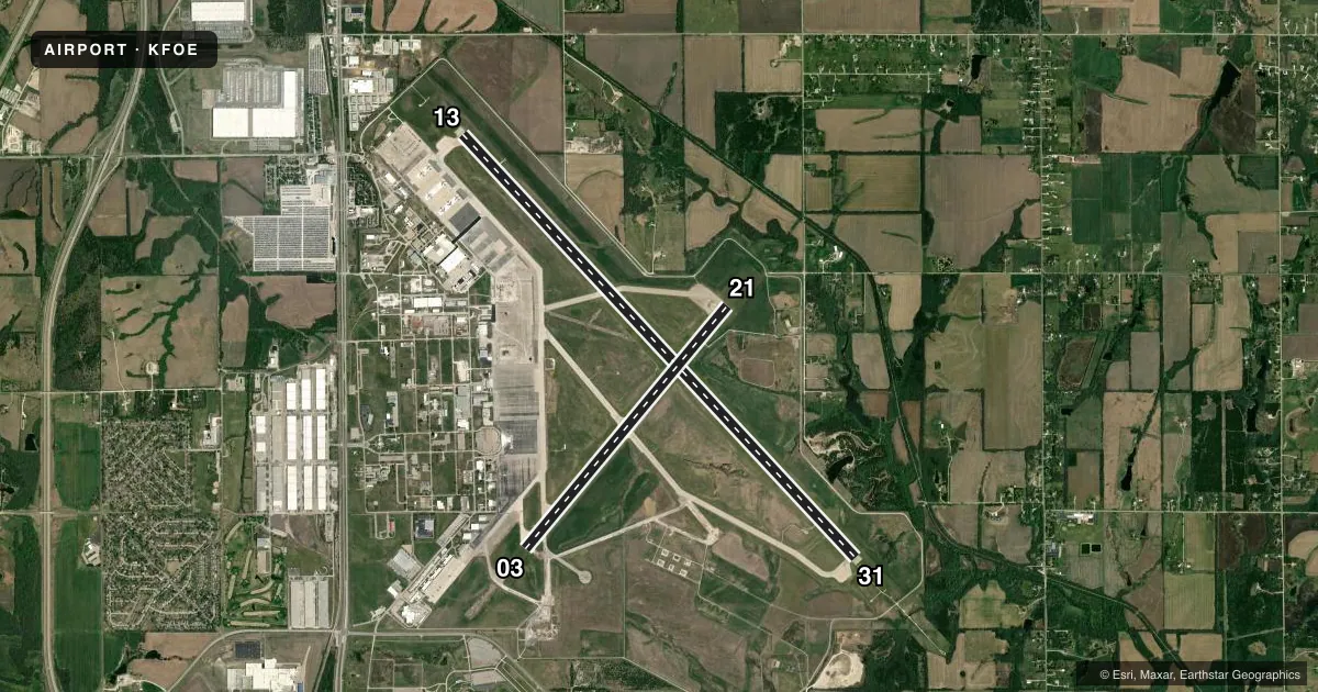
Runways & pattern
Full pagePattern entry · RWY 21
LEFT TRAFFIC| Runway | Heading (°M) | Length | Surface | Traffic |
|---|---|---|---|---|
| 13/31 | 132° / 312° | 12,803 ft | CONC | 13 R |
| 03/21Favored | 35° / 215° | 7,002 ft | ASPH | 03 R |
Runway end performance
| End | TORA | TODA | ASDA | LDA | VGSI | Approach lights | Obstruction |
|---|---|---|---|---|---|---|---|
| 13 | 12,803' | 12,803' | 12,803' | 12,803' | PAPI 4-box left(3°) | MALSF | 35', tree, 1750' from thr, 300' R of cntrln, slope 44 |
| 31 | 12,803' | 12,803' | 12,803' | 12,803' | PAPI 4-box left(3°) | MALSR | 59', tree, 2900' from thr, 500' R of cntrln, slope 45 |
| 03 | 7,001' | 7,001' | 7,001' | 7,001' | VASI 4-box left(3°) | — | — |
| 21 | 7,001' | 7,001' | 7,001' | 7,001' | PAPI 4-box left(3°) | — | 36', tree, 1850' from thr, 200' R of cntrln, slope 45 |
Declared distances in feet. TORA = takeoff run available, TODA = takeoff distance, ASDA = accelerate-stop, LDA = landing distance.
Airport sketch
Runways drawn to scale from FAA survey coordinates, rendered over satellite imagery. Not for navigation.
Approaches & charts
ILS · 1
Services on the field
Fuel grades, oxygen, maintenance, ramp storage and lighting — as declared to the FAA by the airport operator.
Fuel & services
- Fuel
- 100LLA
- Airframe repair
- Major
- Power plant repair
- Major
- Other services
- AFRT,CHTR,INSTR,RNTL,SALES
Ramp & ground
- Transient storage
- Tie-down
- Hangar
- Landing fee
- No fee published
- Customs
- Not available
- Lighting schedule
- SEE RMK
- Beacon schedule
- SS-SR
- Beacon
- Split White / Green (military)(SWG)
- Wind indicator
- Lighted
- Segmented circle
- No
Fuel & FBOs
Cheapest 100LL and Jet A on the field and nearby. Always confirm with the FBO before taxi.
Airport notes
Surface conditions, obstructions, local procedures, lighting outages and other notes published with each FAA cycle.
General notes
- TFC PTN: 1000 FT AGL FOR LGT (SLOW) ACFT & 1500 FT FOR HEAVY (FAST) ACFT.
- (E110) OPERS ARPT LGTG ONLY.
- BIRDS ON & INVOF ARPT. BIRD HAZ PHASE II APR-MAY & AUG-OCT.
- JASU: 14(A/M32A-86D) 11(A/M32A-95)
- FUEL: A+ MILLION AIRTOPEKA 1200-0400Z++ - C785-862-0950; OTR TIMES 3 HR PPR - C785-862-6104/785-224-2899. A++ MIL.
- FLUID: ADI SP LPOX LOX OIL - O-128-148(MIL) - AVBL ONLY IN QT CANS.
- CTN: DO NOT MISTAKE PHILIP BILLARD MUNI 7 NM N FOR TOPEKA RGNL.
- NOISE ABATEMENT PROC: VFR TFC AVOID OVFT OF HOUSING AREA 2 NM W RWY 13.
- ANG: RAMP & SVC 72 HR PPR - C785-861-4655/4663. ANG RAMP PRKG - WYLIE CON 20 MIN BFR LDG. ADZ ARR & DEP - 255.5. AIRFIELD MGMT, MOC & POL 1330-2200Z++; CLSD WKEND & FED HOL; AFT HR PPR.
- ANG: FLEET SVC, OIL SOAP SAMPLING & DRAG CHUTE REPACK NA. PRECISION MEASURING EQPT LAB PUP & DLVR EXP 1.5 HR DLA. TSNT SVC & DEICING AVBL AT FBO. TSNT MAINT & PARTS SVC EXC KC-135R LTD. NO QTRS AVBL.
- ARNG - OPR 1300-2300Z++ TUE-FRI EXC HOL, OCNL SAT, SUN. LTD MAINT UH-60. TRAN ARMY ACFT CTC C785-646-3825. ARMY ACFT CTC TOPEKA GUARD OPS 38.50 OR 238.250. OPS C785-646-3825 OR 3827. RAMP AND FAC W OF RWY 03 APCH END OF RWY.
- F/W & R/W RAPID REFUEL 0600-2200 - 785-862-0950. 24 HR PN & ARINC BFR LNDG - 129.85. ADZ ATC FOR RAPID REFUEL OPS & PROC TO N RAMP. 5 ACFT SIMUL OPS AVBL.
Lighting notes
- WHEN ATCT CLSD ACTVT MALSF RWY 13; MALSR RWY 31; MIRL RWY 03/21; HIRL RWY 13/31 - CTAF. VASI RWY 03; PAPI RWY 13, 21 & 31; OPR CONSLY.
Runway surface & condition
- 03/21PCR VALUE: 2200/F/D/X/T
- 13/31PCR VALUE: 1210/R/D/W/T
Approach & departure obstructions
- 13OTS.
Other notes
- 24 HR PPR FOR UNSKED ACR OPS GTR THAN 30 PAX SEATS - AMGR. ARFF INDEX B AVBL; ARFF INDEX C LEVEL EQUIP AVBL UPON REQ.
- 1MIL USE: SEE FLIP AP/1 SUPPLEMENTARY ARPT RMK.
VFR map & nearby airports
VFR sectional. Tap any ICAO chip to open that airport.
Key facts · KFOE
Answer card- ICAO
- KFOE
- Name
- TOPEKA RGNL
- Location
- TOPEKA, KANSAS
- Elevation
- 1,077.9 ft MSL
- Traffic pattern altitude
- 2,077.9 ft MSL (1,000 AGL)
- Control tower
- Towered · 0545-2200
- Total runways
- 2
- Longest runway
- 13/31 · 12,803 ft
- Published ILS approaches
- 1
- Published frequencies
- 10
- Magnetic variation
- 5°
- Current flight rules
- VFR
- Current wind
- 200° at 12 kt
- Favored runway now
- RWY 21
Topeka Regional sits in Topeka, Kansas. Field elevation is 1,077.9 ft MSL. The airport has 2 runways. The longest is runway 13/31 at 12,803 ft. Runway 03/21 is 7,002 ft. The tower is open daily from 0545 to 2200. One ILS approach is published for runway 31. Pattern altitude is not published. Use the standard 1,000 ft AGL pattern for light piston traffic unless ATC gives you something different.
Million Air Topeka is on the field. It carries 100LL and Jet A Prist. Call (785) 862-0950 for current service details. The airport also has published rapid refuel procedures. Check current coordination requirements before you arrive if you need that service. The field is active with military traffic. Army National Guard and Air National Guard operations are part of the picture here. Expect a busy ramp environment at times.
Noise abatement matters here. VFR traffic should avoid overflying the housing area 2 NM west of runway 13. Birds are also present on and near the airport. The airport is continuously operated. If you are flying in after tower hours, the published lighting procedures matter. Review the current Chart Supplement before departure so you have the latest lighting, ramp and special-use notes for KFOE.