METAR & TAF 69K
69K does not publish a METAR.
Showing the nearest reporting station: KMHK (MANHATTAN RGNL) · 19.5 NM away. Conditions at 69K may differ.
METAR · KMHK
Observed 16:52Z
KMHK 271652Z AUTO 20010KT 10SM CLR 34/23 A2980 RMK AO2 SLP076 T03390228
- Wind
- 200° @ 10 kt
- Visibility
- 10 SM
- Temp / Dew
- 34°C / 23°C
- Altimeter
- 29.80 inHg
- Clouds
- CLR
- Density alt
- 3,627 ft
- Ceiling
- Unlimited
- Rules
- VFR
Airport info & contacts
Manager on record, flight service, ARTCC, attendance schedule and pattern altitude — published by the FAA and refreshed every 28 days.
Location
- From city
- 3 NM E
- VFR sectional
- KANSAS CITY
- ARTCC
- ZKC · KANSAS CITY
- NOTAM facility
- ICT (NOTAM-D)
Airport manager
- Name
- KEN STEIN
- Phone
- 785-456-9119
- Address
- 430 LINCOLN, WAMEGO KS 66547-0086
Flight service · Hours
- FSS ICT
- WICHITA1-800-WX-BRIEF
- Attendance
- Unattended
Frequencies
Tap any row to copy the frequency to your clipboard.
Runways & pattern
Full pagePattern entry · RWY 18
LEFT TRAFFICRunway end performance
| End | TORA | TODA | ASDA | LDA | VGSI | Approach lights | Obstruction |
|---|---|---|---|---|---|---|---|
| 18 | — | — | — | — | — | — | 15', road, 200' from thr, 105' R of cntrln, slope 0 |
| 36 | — | — | — | — | — | — | 17', road, 200' from thr, 96' R of cntrln, slope 0 |
Declared distances in feet. TORA = takeoff run available, TODA = takeoff distance, ASDA = accelerate-stop, LDA = landing distance.
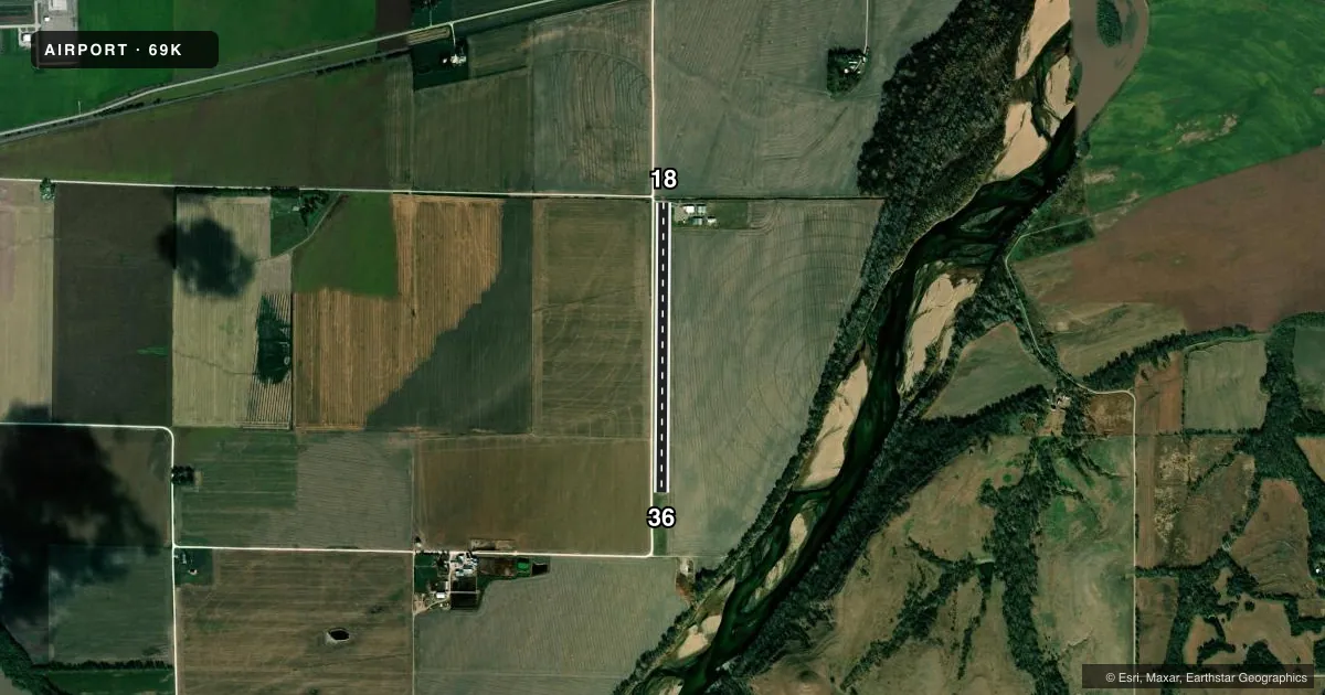
Airport sketch
Runways drawn to scale from FAA survey coordinates, rendered over satellite imagery. Not for navigation.
Approaches & charts
Services on the field
Fuel grades, oxygen, maintenance, ramp storage and lighting — as declared to the FAA by the airport operator.
Fuel & services
- Fuel
- 100LL
- Oxygen (bottled)
- Not available
- Oxygen (bulk)
- Not available
- Airframe repair
- Not available
- Power plant repair
- Not available
Ramp & ground
- Transient storage
- Tie-down
- Landing fee
- No fee published
- Lighting schedule
- SEE RMK
- Beacon schedule
- SS-SR
- Beacon
- White / Green (civil land)(WG)
- Wind indicator
- Yes
- Segmented circle
- No
Fuel & FBOs
Cheapest 100LL and Jet A on the field and nearby. Always confirm with the FBO before taxi.
Airport notes
Surface conditions, obstructions, local procedures, lighting outages and other notes published with each FAA cycle.
General notes
- ULTRALIGHT ACTIVITY ON & INVOF ARPT.
- COUNTY ROAD 75 FT WEST OF RY WITHIN SFC AREA.
- FOR CD CTC KANSAS CITY ARTCC AT 913-254-8508.
Lighting notes
- ACTVT LIRL RWY 18/36 - CTAF.
Fuel notes
- 100LLAVBL 24 HRS WITH CREDIT CARD.
Runway surface & condition
- 18/36NSTD LIRL; RWY LGTS LCTD 13 FT OUTSIDE RWY EDGE. RWY END LGTS AER 36 LCTD 14 FT N OF THLD. RWY END LGTS AER 18 LCTD AT DSPLCD THLD BAR.
Approach & departure obstructions
- 36+15 FT COUNTY RD.
- 18+15 FT COUNTY RD & +15 ARPT ACCESS RD.
- 18+15 FT ACCESS RD, DSTC 0 FT FM RY END, 11:1 BASED ON DSPLCD THLD.
Other notes
- OWNERSTREET ADDRESS: 430 LINCOLN
- OWNERSTACIE EICHEM, CITY MGR
- MANAGER24 HR PHONE 456-9553 (POLICE DEPT).
VFR map & nearby airports
VFR sectional. Tap any ICAO chip to open that airport.
Key facts · 69K
Answer card- ICAO
- 69K
- Name
- WAMEGO MUNI
- Location
- WAMEGO, KANSAS
- Elevation
- 966 ft MSL
- Traffic pattern altitude
- 1,966 ft MSL (1,000 AGL)
- Control tower
- Non-towered (use CTAF)
- Total runways
- 1
- Longest runway
- 18/36 · 3,184 ft
- Published ILS approaches
- 0
- Published frequencies
- 1
- Magnetic variation
- 6°
- Current flight rules
- VFR
- Current wind
- 200° at 10 kt
- Favored runway now
- RWY 18
Wamego Muni sits in Wamego, Kansas. The field elevation is 966 ft MSL. It has one runway, 18/36, which is 3,184 ft long. There is no control tower. CTAF is 122.9. No ILS approaches are published here. The pattern altitude is not published in the facts, so use the current Chart Supplement before you fly the pattern.
This is a simple local field, but there are a few things to brief before arrival. Published remarks note ultralight activity on and near the airport. There are also several obstructions near both runway ends, including roads close to the thresholds. Runway 18/36 has nonstandard low intensity lights. Use CTAF to activate the lights. 100LL is available 24 hours with credit card. Clearance delivery is handled through Kansas City ARTCC at 913-254-8508. There are no on-field FBOs listed. Call the airport operator or the field directly before arrival if you need ramp or fuel details. The airport is in a non-towered environment. Standard see-and-avoid discipline matters here. Expect local traffic, ultralights and close-in obstacles near the runway ends.