METAR & TAF K63
K63 does not publish a METAR.
Showing the nearest reporting station: KEMP (EMPORIA MUNI) · 27.5 NM away. Conditions at K63 may differ.
METAR · KEMP
Observed 18:53Z
KEMP 271853Z AUTO 21011G21KT 10SM CLR 37/22 A2982 RMK AO2 SLP085 T03670222
- Wind
- 210° @ 11G21 kt
- Visibility
- 10 SM
- Temp / Dew
- 37°C / 22°C
- Altimeter
- 29.82 inHg
- Clouds
- CLR
- Density alt
- 4,511 ft
- Ceiling
- Unlimited
- Rules
- VFR
Airport info & contacts
Manager on record, flight service, ARTCC, attendance schedule and pattern altitude — published by the FAA and refreshed every 28 days.
Location
- From city
- 3 NM NW
- VFR sectional
- KANSAS CITY
- ARTCC
- ZKC · KANSAS CITY
- NOTAM facility
- ICT (NOTAM-D)
Airport manager
- Name
- JEFF BARBO
- Phone
- 785-466-6780
- Address
- 205 UNION ST., COUNCIL GROVE KS 66846
Flight service · Hours
- FSS ICT
- WICHITA1-800-WX-BRIEF
- Attendance
- Unattended
Frequencies
Tap any row to copy the frequency to your clipboard.
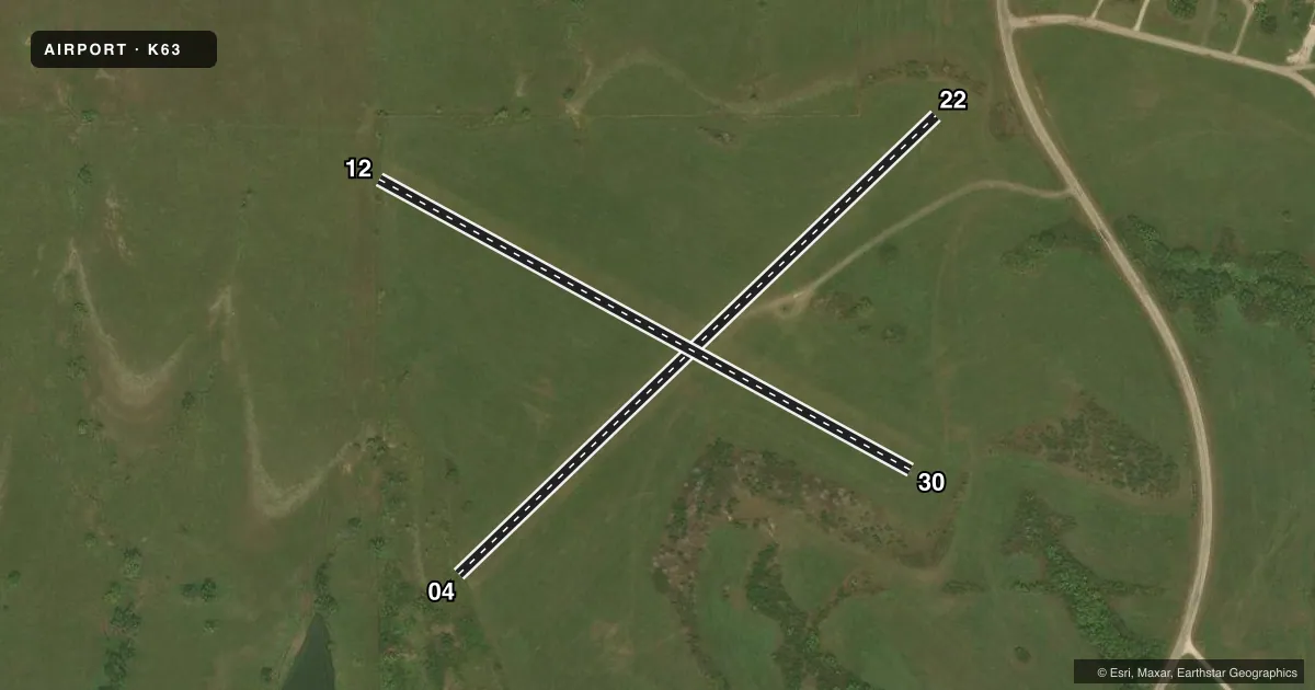
Runways & pattern
Full pagePattern entry · RWY 22
LEFT TRAFFIC| Runway | Heading (°M) | Length | Surface | Traffic |
|---|---|---|---|---|
| 04/22Favored | 40° / 220° | 1,845 ft | TURF | Standard L |
| 12/30 | 113° / 293° | 1,690 ft | TURF | Standard L |
Runway end performance
| End | TORA | TODA | ASDA | LDA | VGSI | Approach lights | Obstruction |
|---|---|---|---|---|---|---|---|
| 04 | — | — | — | — | — | — | 29', trees, 190' from thr, 90' R of cntrln, slope 6 |
| 22 | — | — | — | — | — | — | 20', trees, 0' from thr, 98' R of cntrln, slope 0 |
| 12 | — | — | — | — | — | — | 20', trees, 30' from thr, 70' R of cntrln, slope 1 |
| 30 | — | — | — | — | — | — | 21', trees, 150' from thr, 135' R of cntrln, slope 7 |
Declared distances in feet. TORA = takeoff run available, TODA = takeoff distance, ASDA = accelerate-stop, LDA = landing distance.
Airport sketch
Runways drawn to scale from FAA survey coordinates, rendered over satellite imagery. Not for navigation.
Approaches & charts
Services on the field
Fuel grades, oxygen, maintenance, ramp storage and lighting — as declared to the FAA by the airport operator.
Fuel & services
- Fuel
- Not available
- Oxygen (bottled)
- Not available
- Oxygen (bulk)
- Not available
- Airframe repair
- Not available
- Power plant repair
- Not available
Ramp & ground
- Transient storage
- Tie-down
- Landing fee
- No fee published
- Wind indicator
- No
- Segmented circle
- No
Fuel & FBOs
Cheapest 100LL and Jet A on the field and nearby. Always confirm with the FBO before taxi.
Airport notes
Surface conditions, obstructions, local procedures, lighting outages and other notes published with each FAA cycle.
General notes
- RDO-CTLD MODEL ACFT ACTVTY ON ARPT WKENDS EVES & HOLS.
- FOR CD CTC KANSAS CITY ARTCC AT 913-254-8508.
- NO LINE OF SIGHT BTN RWY ENDS.
- RWY ENDS MKD W/ORANGE BARRELS.
- RWYS SOFT WHEN WET.
Approach & departure obstructions
- 04CONTROLLING OBSTRUCTION EXCEEDS A 45 DEGREE SLOPE
- 044 FT FENCE ACRS THLD.
Other notes
- ARPT ESTABD PRIOR 1959.
VFR map & nearby airports
VFR sectional. Tap any ICAO chip to open that airport.
Key facts · K63
Answer card- ICAO
- K63
- Name
- COUNCIL GROVE MUNI
- Location
- COUNCIL GROVE, KANSAS
- Elevation
- 1,409 ft MSL
- Traffic pattern altitude
- 2,409 ft MSL (1,000 AGL)
- Control tower
- Non-towered (use CTAF)
- Total runways
- 2
- Longest runway
- 04/22 · 1,845 ft
- Published ILS approaches
- 0
- Published frequencies
- 1
- Magnetic variation
- 6°
- Current flight rules
- VFR
- Current wind
- 210° at 11 kt
- Favored runway now
- RWY 22
Council Grove Muni (K63) sits in Council Grove, Kansas. The field elevation is 1,409 ft MSL. It has two turf runways. The longest is 1,845 ft. There is no control tower. CTAF is 122.9.
No ILS approaches are published here. Pattern altitude is not published, so use the standard 1,000 ft AGL for light piston operations unless the current Chart Supplement says otherwise. That puts the pattern at about 2,409 ft MSL based on the listed field elevation.
There are no on-field FBOs listed. Call the airport operator or the field directly for current services before you go. The published remarks matter here. Runway 04 has a controlling obstruction that exceeds a 45 degree slope. There is also a 4-foot fence across the threshold of 04. Runway ends are marked with orange barrels. The runways are soft when wet. There is no line of sight between runway ends. Radio-controlled model aircraft activity occurs on weekends, evenings and holidays. Clearance delivery for IFR departures goes through Kansas City Center at 913-254-8508. A first-time pilot should plan for turf performance. Keep the runway condition in mind after rain. Brief the obstruction near 04 before arrival.