METAR & TAF 3JC
3JC does not publish a METAR.
Showing the nearest reporting station: KMHK (MANHATTAN RGNL) · 9.9 NM away. Conditions at 3JC may differ.
METAR · KMHK
Observed 17:52Z
KMHK 271752Z AUTO 20009KT 10SM CLR 36/23 A2979 RMK AO2 SLP074 T03560233 10356 20267 56003
- Wind
- 200° @ 9 kt
- Visibility
- 10 SM
- Temp / Dew
- 36°C / 23°C
- Altimeter
- 29.79 inHg
- Clouds
- CLR
- Density alt
- 4,047 ft
- Ceiling
- Unlimited
- Rules
- VFR
Airport info & contacts
Manager on record, flight service, ARTCC, attendance schedule and pattern altitude — published by the FAA and refreshed every 28 days.
Location
- From city
- 1 NM NW
- VFR sectional
- KANSAS CITY
- ARTCC
- ZKC · KANSAS CITY
- NOTAM facility
- ICT (NOTAM-D)
Airport manager
- Name
- MARVIN HORNBOSTEL
- Phone
- 785-761-7692
- Address
- RAVEN AREO SERVICES, 540 W 18 THS ST, JUNCTION CITY KS 66441
Flight service · Hours
- FSS ICT
- WICHITA1-800-WX-BRIEF
- Attendance
- 0800-1700
Frequencies
Tap any row to copy the frequency to your clipboard.
Runways & pattern
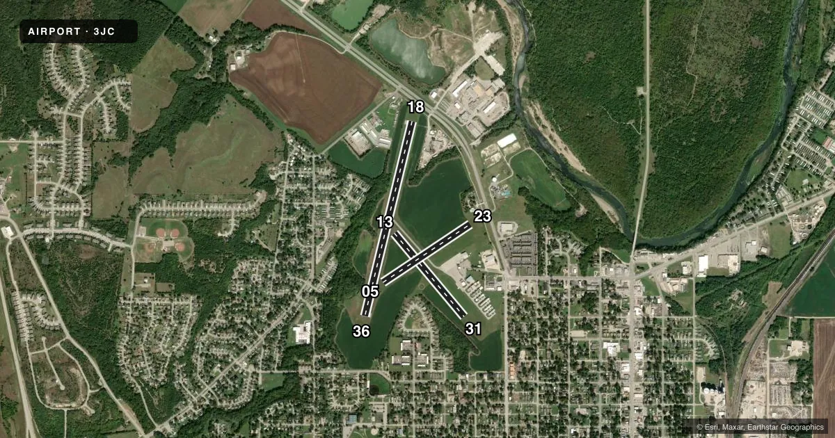
Full pagePattern entry · RWY 18
LEFT TRAFFIC| Runway | Heading (°M) | Length | Surface | Traffic |
|---|---|---|---|---|
| 18/36Favored | 189° / 9° | 3,498 ft | ASPH | Standard L |
| 13/31 | 135° / 315° | 1,903 ft | TURF | Standard L |
| 05/23 | 52° / 232° | 1,834 ft | TURF | Standard L |
Runway end performance
| End | TORA | TODA | ASDA | LDA | VGSI | Approach lights | Obstruction |
|---|---|---|---|---|---|---|---|
| 18 | — | — | — | — | PAPI 2-box left(3°) | — | 25', tree, 245' from thr, 235' R of cntrln, slope 1 |
| 36 | — | — | — | — | PAPI 2-box left(3.5°) | — | 60', trees, 777' from thr, 215' R of cntrln, slope 9 |
| 13 | — | — | — | — | — | — | 40', trees, 328' from thr, 70' R of cntrln, slope 8 |
| 31 | — | — | — | — | — | — | 75', trees, 1530' from thr, 0' R of cntrln, slope 20 |
| 05 | — | — | — | — | — | — | 25', tree, 80' from thr, 115' R of cntrln, slope 3 |
| 23 | — | — | — | — | — | — | 32', pole, 231' from thr, 130' R of cntrln, slope 7 |
Declared distances in feet. TORA = takeoff run available, TODA = takeoff distance, ASDA = accelerate-stop, LDA = landing distance.
Airport sketch
Runways drawn to scale from FAA survey coordinates, rendered over satellite imagery. Not for navigation.
Approaches & charts
Services on the field
Fuel grades, oxygen, maintenance, ramp storage and lighting — as declared to the FAA by the airport operator.
Fuel & services
- Fuel
- 100LLA
- Oxygen (bottled)
- Not available
- Oxygen (bulk)
- Not available
- Airframe repair
- Major
- Power plant repair
- Major
- Other services
- AMB
Ramp & ground
- Transient storage
- Tie-down
- Hangar
- Landing fee
- No fee published
- Customs
- Not available
- Lighting schedule
- SEE RMK
- Beacon schedule
- SS-SR
- Beacon
- White / Green (civil land)(WG)
- Wind indicator
- Lighted
- Segmented circle
- Yes
Fuel & FBOs
Cheapest 100LL and Jet A on the field and nearby. Always confirm with the FBO before taxi.
Airport notes
Surface conditions, obstructions, local procedures, lighting outages and other notes published with each FAA cycle.
General notes
- TURF SOFT WHEN WET.
- NON-STD ATC MINIMA APPLIED IFR ARVLS WITH RESPECT TO HI-PERFORMANCE-ACFT OPNS CONDUCTED WITHIN CFNS OF R-3602.
- WATERFOWL ON & INVOF ARPT.
- FOR CD CTC MARSHALL APCH AT 785-239-2118. WHEN MARSHALL APCH IS CLSD, CTC KANSAS CITY ARTCC AT 913-254-8508.
- COLD TEMPERATURE AIRPORT. ALTITUDE CORRECTION REQUIRED AT OR BELOW -22C.
- BASEBALL FIELD LGT POLES 918 FT TO 1303 FT FM RWY END, 338 FT TO 672 FT RIGHT, 1175 FT AMSL.
- RWY 13 THLD, 4 FT GRADE CHANGE BETWEEN 13 THLD & RWY 18/36. NOT SUITABLE FOR ACFT. MKD W/TIRES.
- RWY 5/23 AND RWY 13/31 THLDS MKD WITH SVRL 12-INCH DIA RAISED STEEL PLATES AS RWY NMBRS ON CL - UNSUITABLE TO TAXI OVER.
Lighting notes
- ACTVT PAPI RWY 36; MIRL RWY 18/36 - CTAF.
Approach & departure obstructions
- 1810 FT BRUSH ALONG FENCE, 0-199 FT DSTC, 240 R.
- 31THLD MKD W/TIRES & BLUE & WHITE BARRELS.
- 05THLD MKD W/BLUE & WHITE PLASTIC BARRELS.
- 13THLD MKD W/BLUE & WHITE PLASTIC BARRELS.
- 23THLD MKD W/BLUE & WHITE PLASTIC BARRELS.
- 1375 FT LIGHT POLES, 900 FT TO THLD, 280 FT R OF CL.
Other notes
- MANAGERFBO PHONE 785-761-7692
VFR map & nearby airports
VFR sectional. Tap any ICAO chip to open that airport.
Key facts · 3JC
Answer card- ICAO
- 3JC
- Name
- FREEMAN FLD
- Location
- JUNCTION CITY, KANSAS
- Elevation
- 1,101.6 ft MSL
- Traffic pattern altitude
- 2,101.6 ft MSL (1,000 AGL)
- Control tower
- Non-towered (use CTAF)
- Total runways
- 3
- Longest runway
- 18/36 · 3,498 ft
- Published ILS approaches
- 0
- Published frequencies
- 4
- Magnetic variation
- 5°
- Current flight rules
- VFR
- Current wind
- 200° at 9 kt
- Favored runway now
- RWY 18
Freeman Fld is in Junction City, Kansas. The field elevation is 1,101.6 ft MSL. It has three runways. The longest is runway 18/36 at 3,498 ft asphalt. Runways 05/23 and 13/31 are turf. There is no control tower. CTAF and UNICOM are both 122.8. No ILS approaches are published.
Pattern altitude is not published. Use the standard 1,000 ft AGL for light piston traffic unless the current Chart Supplement or local procedures say otherwise. Freeman Field is the on-field FBO. It carries 100LL. Call 785-761-7692 before arrival if you need current field details.
This is a cold temperature airport. Altitude correction is required at or below minus 22 degrees Celsius. The turf can be soft when wet. Runway threshold markers and raised steel plates are noted on the turf runways, so taxi carefully and brief the surface condition before you roll. Waterfowl have also been reported on and near the airport. If you are flying IFR, note that non-standard ATC minima apply for arrivals with respect to high-performance aircraft operations inside R-3602. Check the current Chart Supplement and coordinate with ATC if your trip depends on that airspace.