METAR & TAF KCYW
KCYW does not publish a METAR.
Showing the nearest reporting station: KCNK (BLOSSER MUNI) · 24.9 NM away. Conditions at KCYW may differ.
METAR · KCNK
Observed 14:55Z
KCNK 271455Z AUTO 22015KT 10SM CLR 32/18 A2979 RMK AO2 PK WND 21027/1400 SLP066 T03170183 53001
- Wind
- 220° @ 15 kt
- Visibility
- 10 SM
- Temp / Dew
- 32°C / 18°C
- Altimeter
- 29.79 inHg
- Clouds
- CLR
- Density alt
- 3,700 ft
- Ceiling
- Unlimited
- Rules
- VFR
Airport info & contacts
Manager on record, flight service, ARTCC, attendance schedule and pattern altitude — published by the FAA and refreshed every 28 days.
Location
- From city
- 2 NM W
- VFR sectional
- WICHITA
- ARTCC
- ZKC · KANSAS CITY
- NOTAM facility
- ICT (NOTAM-D)
Airport manager
- Name
- SCOTT HEINEN
- Phone
- (800) 760-4964
- Address
- 1226 104TH ROAD, SENECA KS 66538
Flight service · Hours
- FSS ICT
- WICHITA1-800-WX-BRIEF
- Attendance
- 0800-1700
Frequencies
Tap any row to copy the frequency to your clipboard.
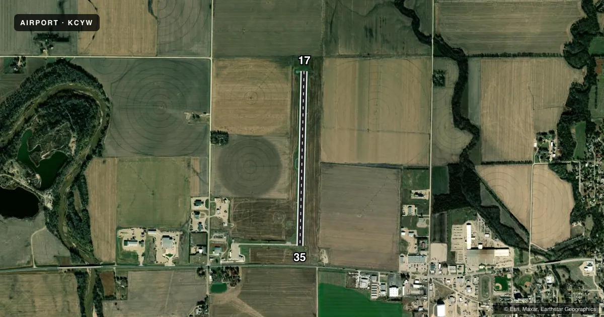
Runways & pattern
Full pagePattern entry · RWY 17
LEFT TRAFFICRunway end performance
| End | TORA | TODA | ASDA | LDA | VGSI | Approach lights | Obstruction |
|---|---|---|---|---|---|---|---|
| 17 | — | — | — | — | PAPI 2-box left(2.75°) | — | — |
| 35 | — | — | — | — | PAPI 2-box left(2.75°) | — | 14', road, 465' from thr, 320' R of cntrln, slope 18 |
Declared distances in feet. TORA = takeoff run available, TODA = takeoff distance, ASDA = accelerate-stop, LDA = landing distance.
Airport sketch
Runways drawn to scale from FAA survey coordinates, rendered over satellite imagery. Not for navigation.
Approaches & charts
Services on the field
Fuel grades, oxygen, maintenance, ramp storage and lighting — as declared to the FAA by the airport operator.
Fuel & services
- Fuel
- 100LL
- Oxygen (bottled)
- Not available
- Oxygen (bulk)
- Not available
- Airframe repair
- Major
- Power plant repair
- Major
- Other services
- CHTR,INSTR,RNTL,SALES
Ramp & ground
- Transient storage
- Tie-down
- Hangar
- Landing fee
- No fee published
- Customs
- Not available
- Lighting schedule
- SEE RMK
- Beacon schedule
- SS-SR
- Beacon
- White / Green (civil land)(WG)
- Wind indicator
- Lighted
- Segmented circle
- Yes
Fuel & FBOs
Cheapest 100LL and Jet A on the field and nearby. Always confirm with the FBO before taxi.
Airport notes
Surface conditions, obstructions, local procedures, lighting outages and other notes published with each FAA cycle.
General notes
- FOR CD CTC MARSHALL APCH AT 785-239-2118. WHEN MARSHALL APCH IS CLSD, CTC KANSAS CITY ARTCC AT 913-254-8508.
Lighting notes
- ACTVT REIL RWY 17 & 35; PAPI RWY 17 & 35 - CTAF. RWY 17/35 MIRL PRESET LOW INTST DUSK-2200; TO INCR INTST OR ACTVT - CTAF.
Approach & departure obstructions
- 17OBSTN CLNC SLP 49:1 TO DTHR.
- 17CROPS AND IRRIGATION EQUIPMENT IN AER 17.
Other notes
- 1FOR AFT HRS SVC CALL 785-757-4551.
VFR map & nearby airports
VFR sectional. Tap any ICAO chip to open that airport.
Key facts · KCYW
Answer card- ICAO
- KCYW
- Name
- CLAY CENTER MUNI
- Location
- CLAY CENTER, KANSAS
- Elevation
- 1,208.9 ft MSL
- Traffic pattern altitude
- 2,208.9 ft MSL (1,000 AGL)
- Control tower
- Non-towered (use CTAF)
- Total runways
- 1
- Longest runway
- 17/35 · 4,197 ft
- Published ILS approaches
- 0
- Published frequencies
- 4
- Magnetic variation
- 4°
- Current flight rules
- VFR
- Current wind
- 220° at 15 kt
- Favored runway now
- RWY 17
Clay Center Muni is in Clay Center, Kansas. The field elevation is 1,208.9 ft MSL. It has one runway, 17/35, which is 4,197 ft long. There is no control tower. Pattern altitude is not published, so plan on the standard 1,000 ft AGL for light piston traffic unless the current Chart Supplement says otherwise.
No ILS approaches are published here. For clearance delivery, Marshall Approach handles it when available. When Marshall Approach is closed, use Kansas City Center. CTAF and UNICOM are both 122.8. The runway lighting is pilot-controlled on CTAF. Runway end identifier lights are active on 17 and 35. The PAPI is also on 17 and 35. The medium intensity runway lights are preset to low intensity from dusk to 2200.
For a first-time arrival, pay attention to the published obstructions near runway 17. Crops and irrigation equipment are in the approach area. The published obstacle clearance slope to the displaced threshold on 17 is 49 to 1. That makes a stabilized approach important. There are no on-field FBOs listed, so call the airport operator or the field directly before arrival if you need fuel or ramp details. For after-hours service, use the published airport phone number before you go.