METAR & TAF KMYZ
Current METAR
Observed 18:15Z
KMYZ 271815Z AUTO 21007KT 10SM CLR 35/20 A2980 RMK AO2
- Wind
- 210° @ 7 kt
- Visibility
- 10 SM
- Temp / Dew
- 35°C / 20°C
- Altimeter
- 29.80 inHg
- Clouds
- CLR
- Density alt
- 4,140 ft
- Ceiling
- Unlimited
- Rules
- VFR
Airport info & contacts
Manager on record, flight service, ARTCC, attendance schedule and pattern altitude — published by the FAA and refreshed every 28 days.
Location
- From city
- 1 NM NE
- VFR sectional
- KANSAS CITY
- ARTCC
- ZKC · KANSAS CITY
- NOTAM facility
- MYZ (NOTAM-D)
Airport manager
- Name
- CINDY HOLLE, CITY CLERK
- Phone
- 785-562-5331
- Address
- 209 N 8TH ST, MARYSVILLE KS 66508
Flight service · Hours
- FSS ICT
- WICHITA1-800-WX-BRIEF
- Attendance
- Unattended
Frequencies
Tap any row to copy the frequency to your clipboard.
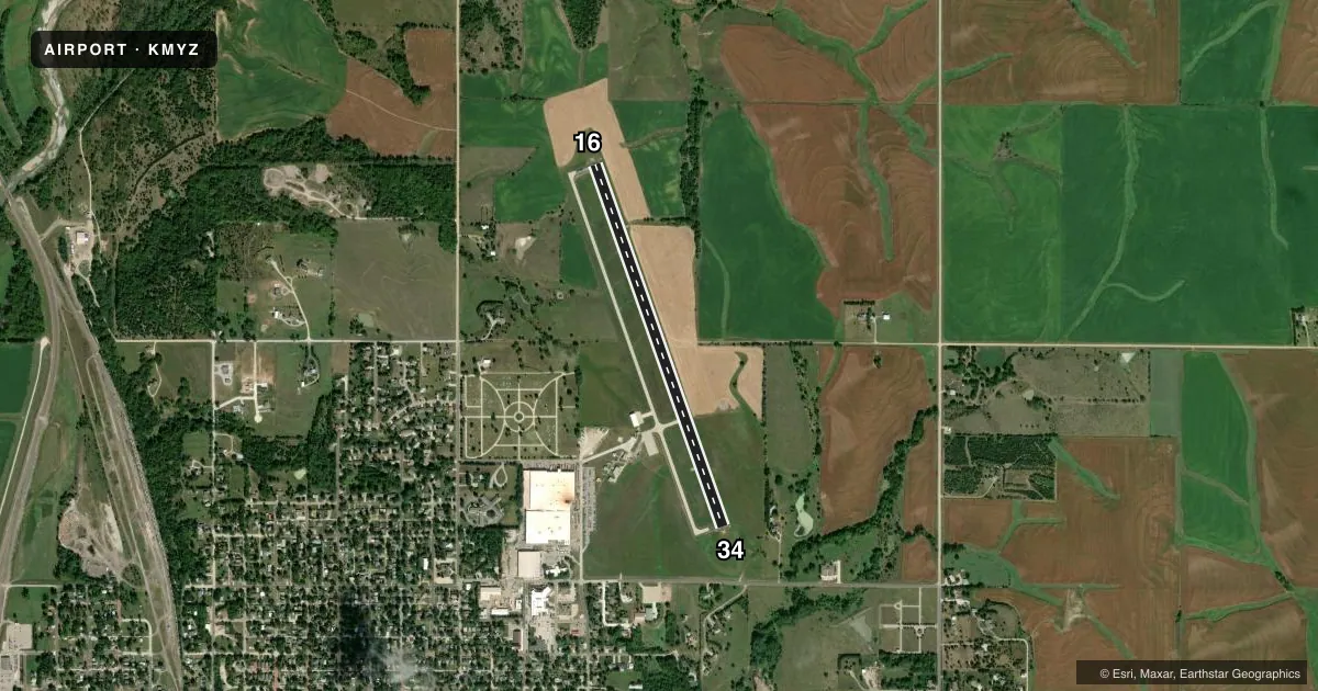
Runways & pattern
Full pagePattern entry · RWY 16
LEFT TRAFFICRunway end performance
| End | TORA | TODA | ASDA | LDA | VGSI | Approach lights | Obstruction |
|---|---|---|---|---|---|---|---|
| 16 | — | — | — | — | PAPI 2-box left(3°) | — | — |
| 34 | — | — | — | — | PAPI 2-box left(3°) | — | 58', trees, 610' from thr, 212' R of cntrln, slope 7 |
Declared distances in feet. TORA = takeoff run available, TODA = takeoff distance, ASDA = accelerate-stop, LDA = landing distance.
Airport sketch
Runways drawn to scale from FAA survey coordinates, rendered over satellite imagery. Not for navigation.
Approaches & charts
Services on the field
Fuel grades, oxygen, maintenance, ramp storage and lighting — as declared to the FAA by the airport operator.
Fuel & services
- Fuel
- Not available
- Airframe repair
- Not available
- Power plant repair
- Not available
Ramp & ground
- Transient storage
- Tie-down
- Landing fee
- No fee published
- Customs
- Not available
- Lighting schedule
- SEE RMK
- Beacon schedule
- SS-SR
- Beacon
- White / Green (civil land)(WG)
- Wind indicator
- Lighted
- Segmented circle
- Yes
Fuel & FBOs
Cheapest 100LL and Jet A on the field and nearby. Always confirm with the FBO before taxi.
Airport notes
Surface conditions, obstructions, local procedures, lighting outages and other notes published with each FAA cycle.
General notes
- TV TWR +499 FT .9 MILES N OF ARPT APRXLY 1/4 MILE L OF AER 16.
- FOR CD CTC KANSAS CITY ARTCC AT 913-254-8508.
Lighting notes
- ACTVT MIRL RWY 16/34; REIL RWY 16/34; PAPI RWY 16 & 34 - CTAF.
Runway surface & condition
- H1NSTD - RED LGTS AT CORNERS OF TLOF. ACTVT ON CTAF.
Approach & departure obstructions
- H1NSTD - TLOF CNTR MKD WITH H ONLY.
VFR map & nearby airports
VFR sectional. Tap any ICAO chip to open that airport.
Key facts · KMYZ
Answer card- ICAO
- KMYZ
- Name
- MARYSVILLE MUNI
- Location
- MARYSVILLE, KANSAS
- Elevation
- 1,283 ft MSL
- Traffic pattern altitude
- 2,283 ft MSL (1,000 AGL)
- Control tower
- Non-towered (use CTAF)
- Total runways
- 1
- Longest runway
- 16/34 · 4,200 ft
- Published ILS approaches
- 0
- Published frequencies
- 2
- Magnetic variation
- 4°
- Current flight rules
- VFR
- Current wind
- 210° at 7 kt
- Favored runway now
- RWY 16
Marysville Muni sits in Marysville, Kansas. The field elevation is 1,283 ft MSL. It has one runway. Runway 16/34 is 4,200 ft long and asphalt. There is no control tower, so use CTAF 122.8 for self-announce traffic and UNICOM on the same frequency. No ILS approaches are published here.
The pattern altitude is not published. Use the standard 1,000 ft AGL for light piston operations unless the current Chart Supplement or local procedures say otherwise. That puts the traffic pattern at about 2,283 ft MSL based on the field elevation. Verify before flight if you need an exact briefing number. The airport has medium intensity runway lights, runway end identifier lights and PAPI for runways 16 and 34. Those lights are activated on CTAF.
A few published remarks matter for planning. There is a 499 ft television tower 0.9 miles north of the airport. It sits about 1/4 mile left of runway 16. The touchdown and liftoff area is marked with an H only. Clearance delivery is handled through Kansas City ARTCC at 913-254-8508. No on-field FBOs are listed. Contact the airport operator directly before arrival or call the field on CTAF or UNICOM for current fuel and service availability.