METAR & TAF 50K
50K does not publish a METAR.
Showing the nearest reporting station: KMYZ (MARYSVILLE MUNI) · 25.4 NM away. Conditions at 50K may differ.
METAR · KMYZ
Observed 19:15Z
KMYZ 271915Z AUTO 22007KT 10SM CLR 35/21 A2979 RMK AO2
- Wind
- 220° @ 7 kt
- Visibility
- 10 SM
- Temp / Dew
- 35°C / 21°C
- Altimeter
- 29.79 inHg
- Clouds
- CLR
- Density alt
- 4,124 ft
- Ceiling
- Unlimited
- Rules
- VFR
Airport info & contacts
Manager on record, flight service, ARTCC, attendance schedule and pattern altitude — published by the FAA and refreshed every 28 days.
Location
- From city
- 2 NM W
- VFR sectional
- OMAHA
- ARTCC
- ZMP · MINNEAPOLIS
- NOTAM facility
- OLU (NOTAM-D)
Airport manager
- Name
- MATT CHRISTEN
- Phone
- 402-335-0256
- Address
- 71493 HIGHWAY 50, 1315 B STREET, PAWNEE CITY NE 68420-6476
Flight service · Hours
- FSS OLU
- COLUMBUS1-800-WX-BRIEF
- Attendance
- ON CALL
Frequencies
Tap any row to copy the frequency to your clipboard.
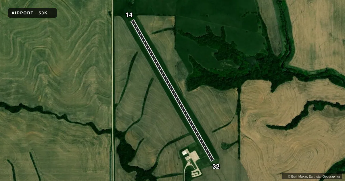
Runways & pattern
Full pagePattern entry · RWY 14
LEFT TRAFFICAirport sketch
Runways drawn to scale from FAA survey coordinates, rendered over satellite imagery. Not for navigation.
Approaches & charts
Services on the field
Fuel grades, oxygen, maintenance, ramp storage and lighting — as declared to the FAA by the airport operator.
Fuel & services
- Fuel
- 100LL
- Oxygen (bottled)
- Not available
- Oxygen (bulk)
- Not available
- Airframe repair
- Major
- Power plant repair
- Major
Ramp & ground
- Transient storage
- Tie-down
- Hangar
- Landing fee
- No fee published
- Customs
- Not available
- Lighting schedule
- SS-SR
- Beacon schedule
- SS-SR
- Beacon
- White / Green (civil land)(WG)
- Wind indicator
- Yes
- Segmented circle
- Yes
Fuel & FBOs
Cheapest 100LL and Jet A on the field and nearby. Always confirm with the FBO before taxi.
Airport notes
Surface conditions, obstructions, local procedures, lighting outages and other notes published with each FAA cycle.
General notes
- FOR CD CTC MINNEAPOLIS ARTCC AT 651-463-5588.
Fuel notes
- 100LLFOR FUEL CALL 402-335-0256.
Other notes
- 1FOR APRT ATTENDANCE CALL AMGR ON 402-335-0256.
VFR map & nearby airports
VFR sectional. Tap any ICAO chip to open that airport.
Key facts · 50K
Answer card- ICAO
- 50K
- Name
- PAWNEE CITY MUNI
- Location
- PAWNEE CITY, NEBRASKA
- Elevation
- 1,260 ft MSL
- Traffic pattern altitude
- 2,260 ft MSL (1,000 AGL)
- Control tower
- Non-towered (use CTAF)
- Total runways
- 1
- Longest runway
- 14/32 · 3,375 ft
- Published ILS approaches
- 0
- Published frequencies
- 1
- Magnetic variation
- 6°
- Current flight rules
- VFR
- Current wind
- 220° at 7 kt
- Favored runway now
- RWY 14
Pawnee City Muni Airport (50K) sits in Pawnee City, Nebraska. Field elevation is 1,260 ft MSL. The airport has one runway. Runway 14/32 is 3,375 ft of turf. The runway headings are 150° and 330° magnetic. No tower is published here. CTAF is 122.9.
No ILS approaches are published for 50K. Pattern altitude is not published in the facts, so use the current FAA Chart Supplement before you fly. For clearance delivery, contact Minneapolis ARTCC at 651-463-5588. For fuel or airport attendance, call 402-335-0256. No on-field FBOs are listed in the facts, so verify current services directly before arrival.
This is a small non-towered field, so plan for self-announce traffic and normal turf-runway technique. Check the runway condition before departure if weather has been wet. The published remarks also point you to the airport manager for attendance, which is useful if you need local field status before you launch.