METAR & TAF 62K
62K does not publish a METAR.
Showing the nearest reporting station: KMYZ (MARYSVILLE MUNI) · 23.7 NM away. Conditions at 62K may differ.
METAR · KMYZ
Observed 18:55Z
KMYZ 271855Z AUTO 20008KT 10SM CLR 35/21 A2979 RMK AO2
- Wind
- 200° @ 8 kt
- Visibility
- 10 SM
- Temp / Dew
- 35°C / 21°C
- Altimeter
- 29.79 inHg
- Clouds
- CLR
- Density alt
- 4,162 ft
- Ceiling
- Unlimited
- Rules
- VFR
Airport info & contacts
Manager on record, flight service, ARTCC, attendance schedule and pattern altitude — published by the FAA and refreshed every 28 days.
Location
- From city
- 3 NM W
- VFR sectional
- KANSAS CITY
- ARTCC
- ZKC · KANSAS CITY
- NOTAM facility
- ICT (NOTAM-D)
Airport manager
- Name
- BRIAN RUSCHE
- Phone
- 785-336-3537
- Address
- 531 MAIN ST., SENECA KS 66538
Flight service · Hours
- FSS ICT
- WICHITA1-800-WX-BRIEF
- Attendance
- Unattended
Frequencies
Tap any row to copy the frequency to your clipboard.
Runways & pattern
Full pagePattern entry · RWY 18
LEFT TRAFFICRunway end performance
| End | TORA | TODA | ASDA | LDA | VGSI | Approach lights | Obstruction |
|---|---|---|---|---|---|---|---|
| 18 | — | — | — | — | — | — | 15', road, 0' from thr, 100' R of cntrln, slope 0 |
| 36 | — | — | — | — | — | — | 5', fence, 0' from thr, 10' R of cntrln, slope 0 |
Declared distances in feet. TORA = takeoff run available, TODA = takeoff distance, ASDA = accelerate-stop, LDA = landing distance.
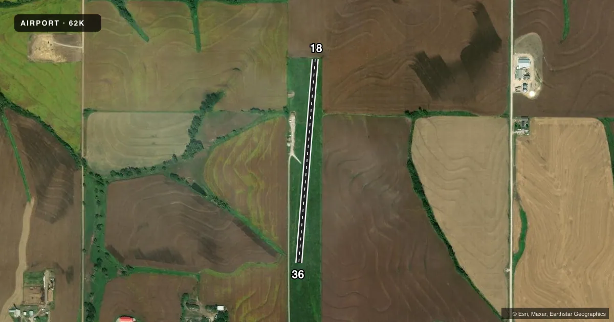
Airport sketch
Runways drawn to scale from FAA survey coordinates, rendered over satellite imagery. Not for navigation.
Approaches & charts
Services on the field
Fuel grades, oxygen, maintenance, ramp storage and lighting — as declared to the FAA by the airport operator.
Fuel & services
- Fuel
- Not available
- Oxygen (bottled)
- Not available
- Oxygen (bulk)
- Not available
- Airframe repair
- Not available
- Power plant repair
- Not available
Ramp & ground
- Transient storage
- Tie-down
- Landing fee
- No fee published
- Lighting schedule
- SS-SR
- Wind indicator
- Yes
- Segmented circle
- No
Fuel & FBOs
Cheapest 100LL and Jet A on the field and nearby. Always confirm with the FBO before taxi.
Airport notes
Surface conditions, obstructions, local procedures, lighting outages and other notes published with each FAA cycle.
General notes
- ULTRALGT ACTVTY ON & INVOF ARPT.
- FOR CD CTC KANSAS CITY ARTCC AT 913-254-8508.
Runway surface & condition
- 18/36RY 36 3.5% INCLINE FIRST 1,000 FT; REMAINDER 2% INCLINE.
- 18/36NSTD LIRL; SPACING MORE THAN 200 FT APART; RY END LGTS ORANGE; AER 18 HAS ONLY 3 RY END LGTS.
Approach & departure obstructions
- 18CONTROLLING OBSTRUCTION EXCEEDS A 45 DEGREE SLOPE
- 18FENCE AER 18 MKD WITH WHITE REFLECTORS.
Other notes
- AREA ONLY. NO ANCHORS OR ROPES.
- 1CALL 785-336-2141 FOR ARPT ACCESS.
- 18/36RWY 18/36 N 1050 FT ROUGH TO INTERSECTION WITH TWY
VFR map & nearby airports
VFR sectional. Tap any ICAO chip to open that airport.
Key facts · 62K
Answer card- ICAO
- 62K
- Name
- SENECA MUNI
- Location
- SENECA, KANSAS
- Elevation
- 1,291 ft MSL
- Traffic pattern altitude
- 2,291 ft MSL (1,000 AGL)
- Control tower
- Non-towered (use CTAF)
- Total runways
- 1
- Longest runway
- 18/36 · 2,400 ft
- Published ILS approaches
- 0
- Published frequencies
- 1
- Magnetic variation
- 6°
- Current flight rules
- VFR
- Current wind
- 200° at 8 kt
- Favored runway now
- RWY 18
Seneca Muni sits in Seneca, Kansas. The field elevation is 1,291 ft MSL. It has one runway. Runway 18/36 is 2,400 ft long and turf. There is no control tower, so use CTAF 122.9 for local traffic calls. No ILS approaches are published here. Pattern altitude is not published, so use the standard 1,000 ft AGL unless current local guidance says otherwise. That puts the light piston pattern at 2,291 ft MSL.
This is an area only field. No anchors or ropes are available, so plan your tie-down setup before you arrive. Access is by phone call to 785-336-2141. Runway 18/36 has nonstandard low intensity lighting with wide spacing. The runway end lights are orange. Approach end runway 18 has only three runway end lights. Runway 18 is rough for the first 1,050 ft north to the taxiway intersection. Runway 36 starts with a 3.5 percent incline for the first 1,000 ft. The rest has a 2 percent incline. There is also a controlling obstruction near runway 18. Ultralight activity is on and near the airport, so keep your scan tight in the pattern. For clearance delivery, contact Kansas City ARTCC at 913-254-8508.