METAR & TAF K91
K91 does not publish a METAR.
Showing the nearest reporting station: KFNB (BRENNER FLD) · 24.2 NM away. Conditions at K91 may differ.
METAR · KFNB
Observed 22:53Z
KFNB 262253Z AUTO 09005KT 10SM OVC018 23/19 A2992 RMK AO2 SLP124 T02280194
- Wind
- 090° @ 5 kt
- Visibility
- 10 SM
- Temp / Dew
- 23°C / 19°C
- Altimeter
- 29.92 inHg
- Clouds
- OVC
- Density alt
- 2,366 ft
- Ceiling
- 1,800 ft AGL
- Rules
- MVFR
Airport info & contacts
Manager on record, flight service, ARTCC, attendance schedule and pattern altitude — published by the FAA and refreshed every 28 days.
Location
- From city
- 1 NM NW
- VFR sectional
- KANSAS CITY
- ARTCC
- ZKC · KANSAS CITY
- NOTAM facility
- ICT (NOTAM-D)
Airport manager
- Name
- JOHN CALHOON
- Phone
- 785-486-2681
- Address
- 202 E. 8TH STREET, HORTON KS 66439
Flight service · Hours
- FSS ICT
- WICHITA1-800-WX-BRIEF
- Attendance
- Unattended
Frequencies
Tap any row to copy the frequency to your clipboard.
Runways & pattern
Full pagePattern entry · RWY 15
LEFT TRAFFIC| Runway | Heading (°M) | Length | Surface | Traffic |
|---|---|---|---|---|
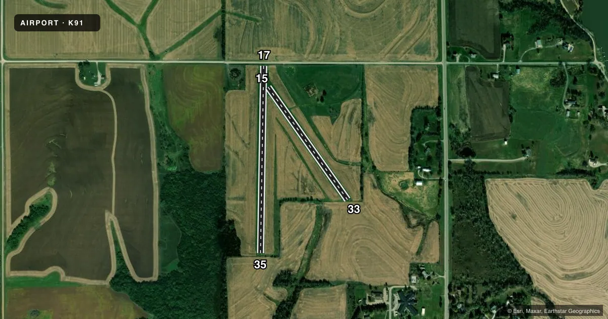
| 17/35 | 175° / 355° | 2,223 ft | TURF | Standard L |
| 15/33Favored | 139° / 319° | 1,636 ft | TURF | Standard L |
Runway end performance
| End | TORA | TODA | ASDA | LDA | VGSI | Approach lights | Obstruction |
|---|---|---|---|---|---|---|---|
| 17 | — | — | — | — | — | — | 20', tree, 10' from thr, 10' R of cntrln, slope 0 |
| 35 | — | — | — | — | — | — | 15', road, 10' from thr, 0' R of cntrln, slope 0 |
| 15 | — | — | — | — | — | — | 15', road, 305' from thr, 0' R of cntrln, slope 20 |
| 33 | — | — | — | — | — | — | 4', fence, 10' from thr, 0' R of cntrln, slope 0 |
Declared distances in feet. TORA = takeoff run available, TODA = takeoff distance, ASDA = accelerate-stop, LDA = landing distance.
Airport sketch
Runways drawn to scale from FAA survey coordinates, rendered over satellite imagery. Not for navigation.
Approaches & charts
Services on the field
Fuel grades, oxygen, maintenance, ramp storage and lighting — as declared to the FAA by the airport operator.
Fuel & services
- Fuel
- Not available
Ramp & ground
- Transient storage
- Not published
- Landing fee
- No fee published
- Customs
- Not available
- Wind indicator
- Lighted
- Segmented circle
- Yes
Fuel & FBOs
Cheapest 100LL and Jet A on the field and nearby. Always confirm with the FBO before taxi.
Airport notes
Surface conditions, obstructions, local procedures, lighting outages and other notes published with each FAA cycle.
General notes
- APT FAC & SNOW REMOVAL NA.
- TIEDOWN AREA & TWY UNMKD; ROUGH & NOT MNTND.
- FOR CD CTC ST JOSEPH APCH AT 816-236-3035. WHEN ST JOSEPH APCH IS CLSD, CTC KANSAS CITY ARTCC AT 913-254-8508.
Approach & departure obstructions
- 33+150 FT UNLGT ANT ON WTR TWR 3684 FT SE OF APCH END.
- 15BDRY; 3 X 5 YELLOW CONC PADS.
- 33BDRY; 3 X 5 YELLOW CONC PADS.
- 35BDRY; 3 X 5 YELLOW CONC PADS.
- 15CTLG OBSTN EXCEEDS 45 DEG SLP.
- 17CTLG OBSTN EXCEEDS 45 DEG SLP.
Other notes
- BUILT PRIOR 1959.
- 1FOR SVC - AMGR OR 785-486-2684.
VFR map & nearby airports
VFR sectional. Tap any ICAO chip to open that airport.
Key facts · K91
Answer card- ICAO
- K91
- Name
- HORTON MUNI
- Location
- HORTON, KANSAS
- Elevation
- 1,134 ft MSL
- Traffic pattern altitude
- 2,134 ft MSL (1,000 AGL)
- Control tower
- Non-towered (use CTAF)
- Total runways
- 2
- Longest runway
- 17/35 · 2,223 ft
- Published ILS approaches
- 0
- Published frequencies
- 1
- Magnetic variation
- 6°
- Current flight rules
- MVFR
- Current wind
- 090° at 5 kt
- Favored runway now
- RWY 15
Horton Muni is in Horton, Kansas. The field elevation is 1,134 ft MSL. It has two turf runways. The longest is 2,223 ft on runway 17/35. There is no control tower. CTAF is 122.9. No ILS approaches are published here.
The pattern altitude is not published, so use the standard 1,000 ft AGL for light piston operations unless the current FAA Chart Supplement says otherwise. This is a small non-towered field, so plan for self-announce traffic and close attention in the pattern. The published remarks also note rough, unmarked tiedown and taxi areas. Airport facilities and snow removal are not available. That matters if you are planning a stop in marginal weather or after a storm.
There are no on-field FBOs listed. For service, contact the airport manager at 785-486-2684. The remarks also say to contact St Joseph Approach at 816-236-3035 for clearance delivery. When St Joseph Approach is closed, contact Kansas City ARTCC at 913-254-8508. Runway ends are marked with yellow concrete pads. There is also a 150-foot unlighted antenna on a water tower southeast of runway 33. Check the current Chart Supplement for any additional local procedures before you go.