METAR & TAF 52K
52K does not publish a METAR.
Showing the nearest reporting station: KMYZ (MARYSVILLE MUNI) · 30.1 NM away. Conditions at 52K may differ.
METAR · KMYZ
Observed 12:55Z
KMYZ 271255Z AUTO 19008KT 10SM CLR 28/18 A2980 RMK AO2
- Wind
- 190° @ 8 kt
- Visibility
- 10 SM
- Temp / Dew
- 28°C / 18°C
- Altimeter
- 29.80 inHg
- Clouds
- CLR
- Density alt
- 3,176 ft
- Ceiling
- Unlimited
- Rules
- VFR
Airport info & contacts
Manager on record, flight service, ARTCC, attendance schedule and pattern altitude — published by the FAA and refreshed every 28 days.
Location
- From city
- 0 NM W
- VFR sectional
- KANSAS CITY
- ARTCC
- ZKC · KANSAS CITY
- NOTAM facility
- ICT (NOTAM-D)
Airport manager
- Name
- ROD TUCKER, MAYOR
- Phone
- (785) 889-4456
- Address
- PO BOX 298, ONAGA KS 66521
Flight service · Hours
- FSS ICT
- WICHITA1-800-WX-BRIEF
- Attendance
- Unattended
Frequencies
Tap any row to copy the frequency to your clipboard.
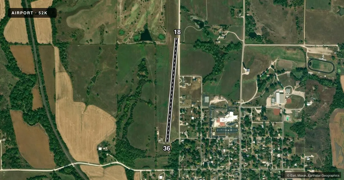
Runways & pattern
Full pagePattern entry · RWY 18
LEFT TRAFFICRunway end performance
| End | TORA | TODA | ASDA | LDA | VGSI | Approach lights | Obstruction |
|---|---|---|---|---|---|---|---|
| 18 | — | — | — | — | — | — | 15', road, 0' from thr, 0' R of cntrln, slope 0 |
| 36 | — | — | — | — | — | — | 15', road, 0' from thr, 60' R of cntrln, slope 0 |
Declared distances in feet. TORA = takeoff run available, TODA = takeoff distance, ASDA = accelerate-stop, LDA = landing distance.
Airport sketch
Runways drawn to scale from FAA survey coordinates, rendered over satellite imagery. Not for navigation.
Approaches & charts
Services on the field
Fuel grades, oxygen, maintenance, ramp storage and lighting — as declared to the FAA by the airport operator.
Fuel & services
- Fuel
- Not available
Ramp & ground
- Transient storage
- Tie-down
- Landing fee
- No fee published
- Lighting schedule
- SEE RMK
- Wind indicator
- Yes
- Segmented circle
- No
Fuel & FBOs
Cheapest 100LL and Jet A on the field and nearby. Always confirm with the FBO before taxi.
Airport notes
Surface conditions, obstructions, local procedures, lighting outages and other notes published with each FAA cycle.
General notes
- FOR CD CTC KANSAS CITY ARTCC AT 913-254-8508.
Lighting notes
- SS-2300.
Runway surface & condition
- 18/36RWY 36 FIRST 600 FT W SIDE ONLY; RMNG WHITE REFLECTORS.
- 18/36VARIES FM 61 FT RWY 36 TO 125 FT MIDFIELD.
Approach & departure obstructions
- 364 WHITE LGTS ON 3 FT PEDESTALS.
- 18CTLG OBSTN EXCEEDS 45 DEG SLP.
Other notes
- 18/36RWY NR MIDFIELD HAS OCNL MINOR DEPRESSIONS.
VFR map & nearby airports
VFR sectional. Tap any ICAO chip to open that airport.
Key facts · 52K
Answer card- ICAO
- 52K
- Name
- CHARLES E GRUTZMACHER MUNI
- Location
- ONAGA, KANSAS
- Elevation
- 1,183 ft MSL
- Traffic pattern altitude
- 2,183 ft MSL (1,000 AGL)
- Control tower
- Non-towered (use CTAF)
- Total runways
- 1
- Longest runway
- 18/36 · 2,200 ft
- Published ILS approaches
- 0
- Published frequencies
- 1
- Magnetic variation
- 6°
- Current flight rules
- VFR
- Current wind
- 190° at 8 kt
- Favored runway now
- RWY 18
Charles E Grutzmacher Muni sits in Onaga, Kansas. Field elevation is 1,183 ft MSL. The airport has one runway. Runway 18/36 is 2,200 ft of turf, so plan your landing and takeoff distances with that surface in mind. This is a non-towered field. CTAF is 122.9.
No ILS approaches are published here. Pattern altitude is not published in the facts, so use the standard 1,000 ft AGL unless the current Chart Supplement says otherwise. The runway lighting is scheduled from sunset to 2300. Runway 36 has lighting on the first 600 ft on the west side only. The rest uses white reflectors. Runway 36 also has four white lights on three foot pedestals. There is an occasional minor depression near midfield. The runway width also varies from 61 ft at runway 36 to 125 ft at midfield.
There are no on-field FBOs listed. Check with the airport operator or the FBO directly by phone before arrival if you need fuel or other services. One published note says a cataloged obstruction near runway 18 exceeds a 45 degree slope. That is worth a close look on your preflight and on final. For clearance delivery, contact Kansas City ARTCC at 913-254-8508.