METAR & TAF KTOP
Current METAR
Observed 18:53Z
KTOP 271853Z 19010G16KT 10SM CLR 36/25 A2978 RMK AO2 SLP072 T03610250
- Wind
- 190° @ 10G16 kt
- Visibility
- 10 SM
- Temp / Dew
- 36°C / 25°C
- Altimeter
- 29.78 inHg
- Clouds
- CLR
- Density alt
- 3,786 ft
- Ceiling
- Unlimited
- Rules
- VFR
Airport info & contacts
Manager on record, flight service, ARTCC, attendance schedule and pattern altitude — published by the FAA and refreshed every 28 days.
Location
- From city
- 3 NM NE
- VFR sectional
- KANSAS CITY
- ARTCC
- ZKC · KANSAS CITY
- NOTAM facility
- TOP (NOTAM-D)
Airport manager
- Name
- ERIC M. JOHNSON
- Phone
- 785-862-2362
- Address
- FORBES FIELD, 6510 SE FORBES AVE, TOPEKA KS 66619
Flight service · Hours
- FSS ICT
- WICHITA1-800-WX-BRIEF
- Attendance
- 0700-2000
Frequencies
Tap any row to copy the frequency to your clipboard.
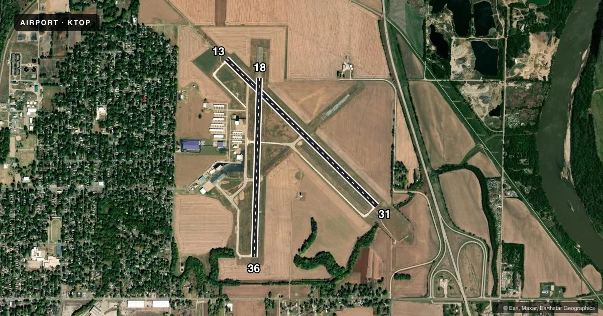
Runways & pattern
Full pagePattern entry · RWY 18
LEFT TRAFFIC| Runway | Heading (°M) | Length | Surface | Traffic |
|---|---|---|---|---|
| 13/31 | 129° / 309° | 5,099 ft | ASPH | Standard L |
| 18/36Favored | 177° / 357° | 4,331 ft | ASPH | Standard L |
Runway end performance
| End | TORA | TODA | ASDA | LDA | VGSI | Approach lights | Obstruction |
|---|---|---|---|---|---|---|---|
| 13 | — | — | — | — | — | MALSR | 107', tree, 2476' from thr, 920' R of cntrln, slope 21 |
| 31 | — | — | — | — | VASI 4-box left(3°) | — | 52', tree, 340' from thr, 410' R of cntrln, slope 2 |
| 18 | — | — | — | — | VASI 4-box left(3°) | — | — |
| 36 | — | — | — | — | VASI 4-box right(3°) | — | 35', trees, 658' from thr, 313' R of cntrln, slope 13 |
Declared distances in feet. TORA = takeoff run available, TODA = takeoff distance, ASDA = accelerate-stop, LDA = landing distance.
Airport sketch
Runways drawn to scale from FAA survey coordinates, rendered over satellite imagery. Not for navigation.
Approaches & charts
ILS · 1
Services on the field
Fuel grades, oxygen, maintenance, ramp storage and lighting — as declared to the FAA by the airport operator.
Fuel & services
- Fuel
- 100LLA
- Oxygen (bottled)
- Low pressure
- Oxygen (bulk)
- Not available
- Airframe repair
- Major
- Power plant repair
- Major
- Other services
- INSTR,RNTL
Ramp & ground
- Transient storage
- Tie-down
- Hangar
- Landing fee
- No fee published
- Customs
- Not available
- Lighting schedule
- SEE RMK
- Beacon schedule
- SS-SR
- Beacon
- White / Green (civil land)(WG)
- Wind indicator
- Lighted
- Segmented circle
- No
Fuel & FBOs
Cheapest 100LL and Jet A on the field and nearby. Always confirm with the FBO before taxi.
Airport notes
Surface conditions, obstructions, local procedures, lighting outages and other notes published with each FAA cycle.
General notes
- LARGE & SMALL MIGRATORY BIRDS ON & INVOF ARPT.
- FOR CD IF UNA TO CTC ON FSS FREQ, CTC KANSAS CITY ARTCC AT 913-254-8508.
Lighting notes
- WHEN ATCT CLSD ACTVT MALSR RWY 13; REIL RWY 18 & 31; VASI RWY 18 & 31; HIRL RWY 13/31; MIRL RWY 18/36 - CTAF.
Fuel notes
- 100LLFOR FUEL AFTER HOURS CALL 785-234-2602.
Other notes
- MULTICOM - 121.900.
VFR map & nearby airports
VFR sectional. Tap any ICAO chip to open that airport.
Key facts · KTOP
Answer card- ICAO
- KTOP
- Name
- PHILIP BILLARD MUNI
- Location
- TOPEKA, KANSAS
- Elevation
- 881.3 ft MSL
- Traffic pattern altitude
- 1,881.3 ft MSL (1,000 AGL)
- Control tower
- Towered · 0700-1900
- Total runways
- 2
- Longest runway
- 13/31 · 5,099 ft
- Published ILS approaches
- 1
- Published frequencies
- 6
- Magnetic variation
- 5°
- Current flight rules
- VFR
- Current wind
- 190° at 10 kt
- Favored runway now
- RWY 18
Philip Billard Muni is in Topeka, Kansas. The field elevation is 881.3 ft MSL. It has two asphalt runways. The longest is 5,099 ft on runway 13/31. The other runway is 18/36 at 4,331 ft. The airport has a control tower. Tower hours are 0700-1900.
One ILS approach is published for runway 13. Pattern altitude is not published in the facts, so verify the current traffic pattern altitude before you go. TOP Fuel Service is on the field. It carries 100LL and Jet A. Call ahead if you need after-hours 100LL. The airport also notes multicom on 121.900.
For a first-time arrival, watch the bird activity. Large and small migratory birds are reported on and near the airport. When the tower is closed, runway lighting and approach lighting for 13, 18, 31 and 18/36 are activated on CTAF. That matters if you are planning a night arrival. Check the current FAA Chart Supplement for any noise or curfew restrictions before flying in. If you need clearance delivery and cannot reach flight service, Kansas City ARTCC is listed as the backup contact.