METAR & TAF 51K
51K does not publish a METAR.
Showing the nearest reporting station: KIXD (NEW CENTURY AIRCENTER) · 6.0 NM away. Conditions at 51K may differ.
METAR · KIXD
Observed 19:53Z
KIXD 231953Z 14007KT 10SM CLR 26/16 A3014 RMK AO2 SLP196 T02560156 $
- Wind
- 140° @ 7 kt
- Visibility
- 10 SM
- Temp / Dew
- 26°C / 16°C
- Altimeter
- 30.14 inHg
- Clouds
- CLR
- Density alt
- 2,317 ft
- Ceiling
- Unlimited
- Rules
- VFR
Airport info & contacts
Manager on record, flight service, ARTCC, attendance schedule and pattern altitude — published by the FAA and refreshed every 28 days.
Location
- From city
- 4 NM NW
- VFR sectional
- KANSAS CITY
- ARTCC
- ZKC · KANSAS CITY
- NOTAM facility
- COU (NOTAM-D)
Airport manager
- Name
- MIKE WILLIAMS
- Phone
- 913-782-5176
- Address
- 25900 COLLEGE BLVD., OLATHE KS 66061
Flight service · Hours
- FSS COU
- COLUMBIA1-800-WX-BRIEF
- Attendance
- UNATNND
Frequencies
Tap any row to copy the frequency to your clipboard.
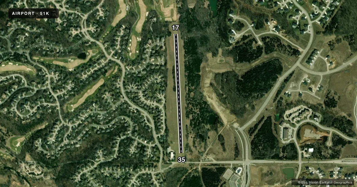
Runways & pattern
Full pagePattern entry · RWY 17
LEFT TRAFFICRunway end performance
| End | TORA | TODA | ASDA | LDA | VGSI | Approach lights | Obstruction |
|---|---|---|---|---|---|---|---|
| 17 | — | — | — | — | — | — | 42', trees, 94' from thr, 88' R of cntrln, slope 2 |
| 35 | — | — | — | — | — | — | 72', trees, 145' from thr, 84' R of cntrln, slope 2 |
Declared distances in feet. TORA = takeoff run available, TODA = takeoff distance, ASDA = accelerate-stop, LDA = landing distance.
Airport sketch
Runways drawn to scale from FAA survey coordinates, rendered over satellite imagery. Not for navigation.
Approaches & charts
Services on the field
Fuel grades, oxygen, maintenance, ramp storage and lighting — as declared to the FAA by the airport operator.
Fuel & services
- Fuel
- Not available
- Oxygen (bottled)
- Not available
- Oxygen (bulk)
- Not available
- Airframe repair
- Not available
- Power plant repair
- Not available
Ramp & ground
- Transient storage
- Tie-down
- Landing fee
- No fee published
- Wind indicator
- Yes
- Segmented circle
- No
Fuel & FBOs
Cheapest 100LL and Jet A on the field and nearby. Always confirm with the FBO before taxi.
Airport notes
Surface conditions, obstructions, local procedures, lighting outages and other notes published with each FAA cycle.
General notes
- GOLF COURSE N END OF RY 17 CAN BE MISTAKEN FOR ARPT.
- WILDLIFE ON & INVOF ARPT.
- TREES BOTH SIDES OF RWY.
- FOR CD CTC KANSAS CITY APCH AT 816-329-2710.
Approach & departure obstructions
- 17RY OUTLINED WITH CONC PADS AT 300 FT INTRVLS. RY ENDS MKD WITH YELLOW CONC PADS.
VFR map & nearby airports
VFR sectional. Tap any ICAO chip to open that airport.
Key facts · 51K
Answer card- ICAO
- 51K
- Name
- CEDAR AIR PARK
- Location
- OLATHE, KANSAS
- Elevation
- 1,024 ft MSL
- Traffic pattern altitude
- 2,024 ft MSL (1,000 AGL)
- Control tower
- Non-towered (use CTAF)
- Total runways
- 1
- Longest runway
- 17/35 · 2,440 ft
- Published ILS approaches
- 0
- Published frequencies
- 2
- Magnetic variation
- 5°
- Current flight rules
- VFR
- Current wind
- 140° at 7 kt
- Favored runway now
- RWY 17
Cedar Air Park sits in Olathe, Kansas. Field elevation is 1,024 ft MSL. The airport has one runway, 17/35 and the longest runway is 2,440 ft of turf. There is no control tower. CTAF and UNICOM are both 122.7. No ILS approaches are published here.
Pattern altitude is not published. Use 1,000 ft AGL for light piston operations unless the current Chart Supplement says otherwise. That puts the pattern at 2,024 ft MSL. The field has a few things a first-time pilot should brief before arrival. Trees line both sides of the runway. Wildlife is present on and near the airport. The golf course at the north end of runway 17 can be mistaken for the airport, so keep your eyes out on final.
Runway 17 has concrete pads at 300-foot intervals. The runway ends are marked with yellow concrete pads. For clearance delivery, contact Kansas City Approach at 816-329-2710. No on-field FBOs are listed, so verify current services with the airport operator or call the field directly before you go.