METAR & TAF K34
K34 does not publish a METAR.
Showing the nearest reporting station: KIXD (NEW CENTURY AIRCENTER) · 3.4 NM away. Conditions at K34 may differ.
METAR · KIXD
Observed 20:53Z
KIXD 272053Z 20015G23KT 10SM CLR 37/21 A2980 RMK AO2 SLP076 T03670211 56012
- Wind
- 200° @ 15G23 kt
- Visibility
- 10 SM
- Temp / Dew
- 37°C / 21°C
- Altimeter
- 29.80 inHg
- Clouds
- CLR
- Density alt
- 4,078 ft
- Ceiling
- Unlimited
- Rules
- VFR
Airport info & contacts
Manager on record, flight service, ARTCC, attendance schedule and pattern altitude — published by the FAA and refreshed every 28 days.
Location
- From city
- 1 NM W
- VFR sectional
- KANSAS CITY
- ARTCC
- ZKC · KANSAS CITY
- NOTAM facility
- COU (NOTAM-D)
Airport manager
- Name
- KELLEN HEADLEE
- Phone
- 913-856-0914
- Address
- 31905 W 175 ST, CITY HALL, 120 E MAIN ST., GARDNER KS 66030
Flight service · Hours
- FSS COU
- COLUMBIA1-800-WX-BRIEF
- Attendance
- MON-FRI · 0800-1600
Frequencies
Tap any row to copy the frequency to your clipboard.
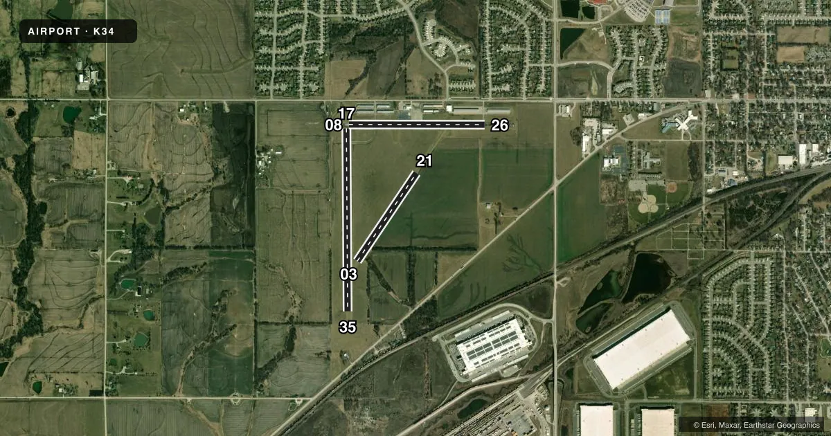
Runways & pattern
Full pagePattern entry · RWY 21
LEFT TRAFFIC| Runway | Heading (°M) | Length | Surface | Traffic |
|---|---|---|---|---|
| 17/35 | 175° / 355° | 3,224 ft | TURF | Standard L |
| 08/26 | 85° / 265° | 2,399 ft | ASPH | Standard L |
| 03/21Favored | 29° / 209° | 1,871 ft | TURF | Standard L |
Runway end performance
| End | TORA | TODA | ASDA | LDA | VGSI | Approach lights | Obstruction |
|---|---|---|---|---|---|---|---|
| 17 | — | — | — | — | — | — | 26', tree, 512' from thr, 15' R of cntrln, slope 19 |
| 35 | — | — | — | — | — | — | 67', trees, 775' from thr, 102' R of cntrln, slope 11 |
| 08 | — | — | — | — | — | — | 3', fence, 311' from thr, 0' R of cntrln, slope 37 |
| 03 | — | — | — | — | — | — | 40', tree, 420' from thr, 115' R of cntrln, slope 10 |
Declared distances in feet. TORA = takeoff run available, TODA = takeoff distance, ASDA = accelerate-stop, LDA = landing distance.
Airport sketch
Runways drawn to scale from FAA survey coordinates, rendered over satellite imagery. Not for navigation.
Approaches & charts
Services on the field
Fuel grades, oxygen, maintenance, ramp storage and lighting — as declared to the FAA by the airport operator.
Fuel & services
- Fuel
- 100LL
- Airframe repair
- Major
- Power plant repair
- Major
- Other services
- GLD,TOW
Ramp & ground
- Transient storage
- Tie-down
- Landing fee
- No fee published
- Customs
- Not available
- Lighting schedule
- SS-SR
- Beacon schedule
- SS-SR
- Beacon
- White / Green (civil land)(WG)
- Wind indicator
- Lighted
- Segmented circle
- No
Fuel & FBOs
Cheapest 100LL and Jet A on the field and nearby. Always confirm with the FBO before taxi.
Airport notes
Surface conditions, obstructions, local procedures, lighting outages and other notes published with each FAA cycle.
General notes
- GLIDER & ULTRALIGHT ACT ON & INVOF ARPT.
- FUEL 24 HRS SELF-SERVE.
- FOR CD CTC KANSAS CITY APCH AT 816-329-2710.
- ACES RWY 17 THR VIA RWY 8 OVRN.
Runway surface & condition
- 08/26NSTD LIRL 35 FT OUTBOARD OF RWY 240 FT SPACINGS. RWY 8 END, ONE LIGHT EACH SIDE OF RWY, RWY 26 END, THREE LIGHTS OUTBOARD EACH SIDE.
- 17/35RWY END LGTS NA.
Approach & departure obstructions
- 17ORANGE BARRELS.
- 35ORANGE BARRELS.
- 0331 FT TREES, R EDGE OF RWY APRX 400 FT DOWN RWY.
Other notes
- PROVIDED THE APPROACH TO EACH RWY IS MAINTAINED FOR A MINIMUM 20:1 GLIDE SLOPE AND THE TRANSITIONAL SURFACE BE MAINTAINED FOR A 7:1 SLOPE.
VFR map & nearby airports
VFR sectional. Tap any ICAO chip to open that airport.
Key facts · K34
Answer card- ICAO
- K34
- Name
- GARDNER MUNI
- Location
- GARDNER, KANSAS
- Elevation
- 1,040 ft MSL
- Traffic pattern altitude
- 2,040 ft MSL (1,000 AGL)
- Control tower
- Non-towered (use CTAF)
- Total runways
- 3
- Longest runway
- 17/35 · 3,224 ft
- Published ILS approaches
- 0
- Published frequencies
- 4
- Magnetic variation
- 5°
- Current flight rules
- VFR
- Current wind
- 200° at 15 kt
- Favored runway now
- RWY 21
Gardner Muni sits in Gardner, Kansas. The field elevation is 1,040 ft MSL. It has three runways. The longest is runway 17/35 at 3,224 ft. This is a non-towered field, so plan on self-announce ops on CTAF 122.8 and keep a sharp scan for local traffic.
No ILS approaches are published here. Pattern altitude is not published, so use the standard 1,000 ft AGL for light piston operations unless the current Chart Supplement says otherwise. Gardner Aviation is on the field. It carries 100LL. Fuel is available 24 hours self-serve. For clearance delivery, Kansas City Approach is the contact listed in the remarks.
A few runway details matter here. Runway 08/26 is asphalt. Runways 03/21 and 17/35 are turf. The remarks also note glider and ultralight activity on and near the airport. That makes the pattern worth flying with extra spacing and good lookout discipline. There are also published obstructions near runway 03, plus orange barrels marking the ends of runways 17 and 35. Runway 08/26 has nonstandard low intensity lighting. If you are planning a night or low-vis arrival, verify the current Chart Supplement and brief the field carefully before you go.