METAR & TAF K81
K81 does not publish a METAR.
Showing the nearest reporting station: KOWI (OTTAWA MUNI) · 15.6 NM away. Conditions at K81 may differ.
METAR · KOWI
Observed 21:30Z
KOWI 272130Z AUTO 21010G18KT 10SM CLR 38/22 A2977 RMK A01
- Wind
- 210° @ 10G18 kt
- Visibility
- 10 SM
- Temp / Dew
- 38°C / 22°C
- Altimeter
- 29.77 inHg
- Clouds
- CLR
- Density alt
- 4,115 ft
- Ceiling
- Unlimited
- Rules
- VFR
Airport info & contacts
Manager on record, flight service, ARTCC, attendance schedule and pattern altitude — published by the FAA and refreshed every 28 days.
Location
- From city
- 3 NM SW
- VFR sectional
- KANSAS CITY
- ARTCC
- ZKC · KANSAS CITY
- NOTAM facility
- ICT (NOTAM-D)
Airport manager
- Name
- CHARLES BARTLETT
- Phone
- 913-594-0978
- Address
- 32549 W 327TH ST, PAOLA KS 66071
Flight service · Hours
- FSS ICT
- WICHITA1-800-WX-BRIEF
- Attendance
- IREG
Frequencies
Tap any row to copy the frequency to your clipboard.
Runways & pattern
Full pagePattern entry · RWY 21
LEFT TRAFFIC| Runway | Heading (°M) | Length | Surface | Traffic |
|---|---|---|---|---|
| 03/21Favored | 35° / 215° | 3,398 ft | ASPH | Standard L |
| 15/33 | 150° / 330° | 1,940 ft | TURF | Standard L |
Runway end performance
| End | TORA | TODA | ASDA | LDA | VGSI | Approach lights | Obstruction |
|---|---|---|---|---|---|---|---|
| 03 | — | — | — | — | PAPI 2-box left(3.4°) | — | 70', trees, 1600' from thr, 26' R of cntrln, slope 20 |
| 21 | — | — | — | — | PAPI 2-box left(3°) | — | 65', tree, 1850' from thr, 295' R of cntrln, slope 25 |
| 15 | — | — | — | — | — | — | 33', pline, 90' from thr, 135' R of cntrln, slope 2 |
Declared distances in feet. TORA = takeoff run available, TODA = takeoff distance, ASDA = accelerate-stop, LDA = landing distance.
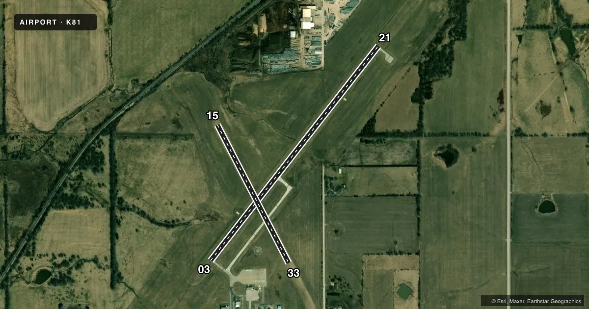
Airport sketch
Runways drawn to scale from FAA survey coordinates, rendered over satellite imagery. Not for navigation.
Approaches & charts
Services on the field
Fuel grades, oxygen, maintenance, ramp storage and lighting — as declared to the FAA by the airport operator.
Fuel & services
- Fuel
- 100LL
- Oxygen (bottled)
- Not available
- Oxygen (bulk)
- Not available
- Airframe repair
- Major
- Power plant repair
- Major
- Other services
- INSTR
Ramp & ground
- Transient storage
- Tie-down
- Landing fee
- No fee published
- Customs
- Not available
- Lighting schedule
- SEE RMK
- Beacon schedule
- SEE RMK
- Beacon
- White / Green (civil land)(WG)
- Wind indicator
- Lighted
- Segmented circle
- Yes
Fuel & FBOs
Cheapest 100LL and Jet A on the field and nearby. Always confirm with the FBO before taxi.
Airport notes
Surface conditions, obstructions, local procedures, lighting outages and other notes published with each FAA cycle.
General notes
- FOR CD CTC KANSAS CITY APCH AT 816-329-2710.
Lighting notes
- DUSK-2400
- ACTVT REIL RWY 03 & 21; PAPI RWY 03 & 21, MIRL RWY 03/21 - CTAF.
Fuel notes
- 100LLFUEL 24 HRS SELF-SERV.
Other notes
- 1AFTR HRS SVC ON REQ.
- MANAGERCHASBART@EMBARQMAIL.COM
- OWNERSHANE KRULL, CO. ADMIN.
VFR map & nearby airports
VFR sectional. Tap any ICAO chip to open that airport.
Key facts · K81
Answer card- ICAO
- K81
- Name
- MIAMI COUNTY
- Location
- PAOLA, KANSAS
- Elevation
- 943.1 ft MSL
- Traffic pattern altitude
- 1,943.1 ft MSL (1,000 AGL)
- Control tower
- Non-towered (use CTAF)
- Total runways
- 2
- Longest runway
- 03/21 · 3,398 ft
- Published ILS approaches
- 0
- Published frequencies
- 4
- Magnetic variation
- 3°
- Current flight rules
- VFR
- Current wind
- 210° at 10 kt
- Favored runway now
- RWY 21
Miami County Airport sits near Paola, Kansas. The field elevation is 943.1 ft MSL. It has two runways. The longest is 3,398 ft. This is a non-towered airport, so expect self-announce traffic on CTAF 122.8. No ILS approaches are published. Pattern altitude is not published. Use the standard 1,000 ft AGL pattern for light piston aircraft unless local guidance says otherwise.
The airport has one on-field FBO listed as Miami County Airport Authority. It carries 100LL. Self-serve 100LL is available 24 hours. The beacon operates from dusk to 2400. Runway 03/21 has medium intensity lights controlled by CTAF. It also has runway end identifier lights and PAPI on both ends. Runway 15/33 is a 1,940 ft turf strip. The asphalt runway 03/21 is the main runway for most arrivals.
For planning, note that Kansas City Approach handles clearance delivery. The published contact is 816-329-2710. If you need current airport details, check the current FAA Chart Supplement or call the airport operator directly. The field is in open country near Paola. That usually means wind and surface conditions matter more than terrain, but the turf runway can still be a factor after rain or during soft-field conditions.