METAR & TAF 63K
63K does not publish a METAR.
Showing the nearest reporting station: KOJC (JOHNSON COUNTY EXEC) · 6.2 NM away. Conditions at 63K may differ.
METAR · KOJC
Observed 15:53Z
KOJC 271553Z 19009G17KT 10SM CLR 31/23 A2986 RMK AO2 SLP096 T03110228 PNO
- Wind
- 190° @ 9G17 kt
- Visibility
- 10 SM
- Temp / Dew
- 31°C / 23°C
- Altimeter
- 29.86 inHg
- Clouds
- CLR
- Density alt
- 3,265 ft
- Ceiling
- Unlimited
- Rules
- VFR
Airport info & contacts
Manager on record, flight service, ARTCC, attendance schedule and pattern altitude — published by the FAA and refreshed every 28 days.
Location
- From city
- 4 NM NE
- VFR sectional
- KANSAS CITY
- ARTCC
- ZKC · KANSAS CITY
- NOTAM facility
- COU (NOTAM-D)
Airport manager
- Name
- WILLIAM C. SHELDON
- Phone
- 913-897-2647
- Address
- 16935 S. KENNETH RD, STILWELL KS 66085
Flight service · Hours
- FSS COU
- COLUMBIA1-800-WX-BRIEF
- Attendance
- Unattended
Frequencies
Tap any row to copy the frequency to your clipboard.
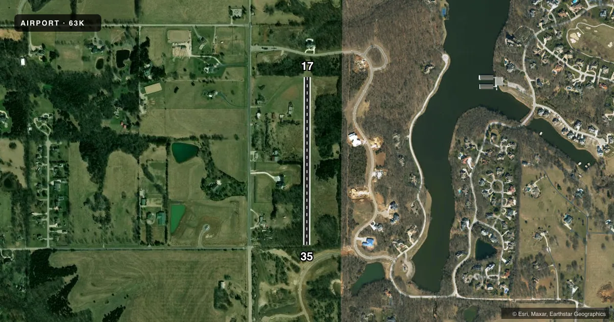
Runways & pattern
Full pagePattern entry · RWY 17
RIGHT TRAFFICRunway end performance
| End | TORA | TODA | ASDA | LDA | VGSI | Approach lights | Obstruction |
|---|---|---|---|---|---|---|---|
| 17 | — | — | — | — | — | — | 51', trees, 149' from thr, 58' R of cntrln, slope 2 |
| 35 | — | — | — | — | — | — | 33', trees, 197' from thr, 92' R of cntrln, slope 5 |
Declared distances in feet. TORA = takeoff run available, TODA = takeoff distance, ASDA = accelerate-stop, LDA = landing distance.
Airport sketch
Runways drawn to scale from FAA survey coordinates, rendered over satellite imagery. Not for navigation.
Approaches & charts
Services on the field
Fuel grades, oxygen, maintenance, ramp storage and lighting — as declared to the FAA by the airport operator.
Fuel & services
- Fuel
- Not available
- Oxygen (bottled)
- Not available
- Oxygen (bulk)
- Not available
- Airframe repair
- Not available
- Power plant repair
- Not available
Ramp & ground
- Transient storage
- Tie-down
- Landing fee
- No fee published
- Wind indicator
- Yes
- Segmented circle
- No
Fuel & FBOs
Cheapest 100LL and Jet A on the field and nearby. Always confirm with the FBO before taxi.
Airport notes
Surface conditions, obstructions, local procedures, lighting outages and other notes published with each FAA cycle.
General notes
- WILDLIFE ON & INVOF ARPT.
- TREES AND UNEVEN TERRAIN BOTH SIDES OF RWY. TREES IN APCH ZONES.
- +10 EARTH EMBANKMENT MID FLD, WEST DGE OF RWY.
- FOR CD CTC KANSAS CITY APCH AT 816-329-2710.
Other notes
- EXISTED PRIOR TO 1959.
- TURF TIE DOWN AREA AVBL; BRING OWN ANCHORS AND CHAINS.
- 17/35RWY ROUGH 550 FT FM AER 35.
VFR map & nearby airports
VFR sectional. Tap any ICAO chip to open that airport.
Key facts · 63K
Answer card- ICAO
- 63K
- Name
- HILLSIDE
- Location
- STILWELL, KANSAS
- Elevation
- 1,025 ft MSL
- Traffic pattern altitude
- 2,025 ft MSL (1,000 AGL)
- Control tower
- Non-towered (use CTAF)
- Total runways
- 1
- Longest runway
- 17/35 · 2,000 ft
- Published ILS approaches
- 0
- Published frequencies
- 1
- Magnetic variation
- 5°
- Current flight rules
- VFR
- Current wind
- 190° at 9 kt
- Favored runway now
- RWY 17
Hillside Airport sits near Stilwell, Kansas. The field elevation is 1,025 ft MSL. It has one runway, 17/35, which is 2,000 ft long with a turf-gravel surface. There is no control tower. CTAF is 122.9. No ILS approaches are published. The pattern altitude is not published, so use the standard 1,000 ft AGL pattern unless the current Chart Supplement says otherwise.
This is a small field with some real operating issues to plan around. Wildlife is reported on and near the airport. Trees and uneven terrain are present on both sides of the runway. Trees also sit in the approach zones. There is a 10-foot earth embankment mid-field on the west edge of the runway. The runway is also reported rough for the first 550 feet from the aerodrome 35 end. That makes a careful walk-through and a conservative performance check a good idea before you go in.
No on-field FBOs are listed. Bring your own tie-down anchors and chains if you plan to park on the turf tie-down area. For clearance delivery, contact Kansas City Approach at 816-329-2710. If you need current operating details, check the current FAA Chart Supplement or call the airport operator directly.