METAR & TAF 53K
53K does not publish a METAR.
Showing the nearest reporting station: KFOE (TOPEKA RGNL) · 20.1 NM away. Conditions at 53K may differ.
METAR · KFOE
Observed 15:53Z
KFOE 271553Z 20010KT 10SM CLR 32/22 A2982 RMK AO2 SLP083 T03220222 $
- Wind
- 200° @ 10 kt
- Visibility
- 10 SM
- Temp / Dew
- 32°C / 22°C
- Altimeter
- 29.82 inHg
- Clouds
- CLR
- Density alt
- 3,535 ft
- Ceiling
- Unlimited
- Rules
- VFR
Airport info & contacts
Manager on record, flight service, ARTCC, attendance schedule and pattern altitude — published by the FAA and refreshed every 28 days.
Location
- From city
- 1 NM E
- VFR sectional
- KANSAS CITY
- ARTCC
- ZKC · KANSAS CITY
- NOTAM facility
- ICT (NOTAM-D)
Airport manager
- Name
- KATIE HODGE
- Phone
- 785-528-3714
- Address
- 201 S 5TH ST, OSAGE CITY KS 66523
Flight service · Hours
- FSS ICT
- WICHITA1-800-WX-BRIEF
- Attendance
- Unattended
Frequencies
Tap any row to copy the frequency to your clipboard.
Runways & pattern
Full pagePattern entry · RWY 17
LEFT TRAFFICRunway end performance
| End | TORA | TODA | ASDA | LDA | VGSI | Approach lights | Obstruction |
|---|---|---|---|---|---|---|---|
| 17 | — | — | — | — | — | — | 60', tree, 784' from thr, 0' R of cntrln, slope 9 |
| 35 | — | — | — | — | — | — | 15', road, 201' from thr, 81' R of cntrln, slope 0 |
Declared distances in feet. TORA = takeoff run available, TODA = takeoff distance, ASDA = accelerate-stop, LDA = landing distance.
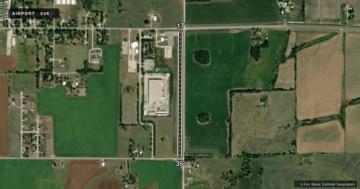
Airport sketch
Runways drawn to scale from FAA survey coordinates, rendered over satellite imagery. Not for navigation.
Approaches & charts
Services on the field
Fuel grades, oxygen, maintenance, ramp storage and lighting — as declared to the FAA by the airport operator.
Fuel & services
- Fuel
- Not available
- Oxygen (bottled)
- Not available
- Oxygen (bulk)
- Not available
- Airframe repair
- Not available
- Power plant repair
- Not available
- Other services
- AGRI,INSTR,PAJA
Ramp & ground
- Transient storage
- Tie-down
- Landing fee
- No fee published
- Lighting schedule
- SS-SR
- Beacon
- White / Green (civil land)(WG)
- Wind indicator
- Lighted
- Segmented circle
- No
Fuel & FBOs
Cheapest 100LL and Jet A on the field and nearby. Always confirm with the FBO before taxi.
Airport notes
Surface conditions, obstructions, local procedures, lighting outages and other notes published with each FAA cycle.
General notes
- PAJA ACTIVITIES SAT & SUN.
- +15 RD 55 FT E OF RWY.
- FOR CD CTC KANSAS CITY ARTCC AT 913-254-8508.
Runway surface & condition
- 17/35RWY END LTS RED, NO SPLIT LENS; DSPLCD THLD LTS GREEN, NO SPLIT LENS.
Approach & departure obstructions
- 17+15 ROAD 50 FT FM RWY END; +35 POLE 140FT FM RWY END 118 FT L OF CNTRLN.
- 35+15 ROAD 27 FT FM RWY END.
- 17APCH RATIO 13:1 FM DSPLCD THLD TO +60 TREES BOTH SIDES OF CNTRLN.
- 35CONTROLLING OBSTN EXCEEDS A 45 DEG SLP.
Other notes
- 17/35SEVERE CRACKING LENGTH OF RWY 17/35.
VFR map & nearby airports
VFR sectional. Tap any ICAO chip to open that airport.
Key facts · 53K
Answer card- ICAO
- 53K
- Name
- OSAGE CITY MUNI
- Location
- OSAGE CITY, KANSAS
- Elevation
- 1,105.9 ft MSL
- Traffic pattern altitude
- 2,105.9 ft MSL (1,000 AGL)
- Control tower
- Non-towered (use CTAF)
- Total runways
- 1
- Longest runway
- 17/35 · 2,539 ft
- Published ILS approaches
- 0
- Published frequencies
- 1
- Magnetic variation
- 6°
- Current flight rules
- VFR
- Current wind
- 200° at 10 kt
- Favored runway now
- RWY 17
OSAGE CITY MUNI sits in Osage City, Kansas. Field elevation is 1,105.9 ft MSL. The airport has one runway. Runway 17/35 is 2,539 ft of asphalt, so plan for a short-field setup if you are bringing in anything larger than a light piston. There is no control tower. CTAF is 122.9.
No ILS approaches are published here. The pattern altitude is not published, so use the standard 1,000 ft AGL for light piston operations unless the current FAA Chart Supplement says otherwise. With the field sitting above 1,100 ft MSL, density altitude can matter on warm days. That is worth keeping in mind on a short runway.
There are no on-field FBOs listed. Contact the airport operator directly or call the field on CTAF for current service availability. Published remarks call out severe cracking along runway 17/35. They also note roads close to both runway ends and trees near the 17 approach path. Runway end lighting is red. Displaced threshold lights are green. PAJA activity occurs on Saturday and Sunday. For clearance delivery, contact Kansas City ARTCC at 913-254-8508. Check the current FAA Chart Supplement before you go for any updated operational notes or restrictions.