METAR & TAF K83
Current METAR
Observed 21:35Z
KK83 272135Z AUTO 24005KT 10SM CLR 37/23 A2981 RMK AO2 T03650233
- Wind
- 240° @ 5 kt
- Visibility
- 10 SM
- Temp / Dew
- 37°C / 23°C
- Altimeter
- 29.81 inHg
- Clouds
- CLR
- Density alt
- 4,423 ft
- Ceiling
- Unlimited
- Rules
- VFR
Airport info & contacts
Manager on record, flight service, ARTCC, attendance schedule and pattern altitude — published by the FAA and refreshed every 28 days.
Location
- From city
- 1 NM E
- VFR sectional
- KANSAS CITY
- ARTCC
- ZKC · KANSAS CITY
- NOTAM facility
- ICT (NOTAM-D)
Airport manager
- Name
- DOUG ALLEN - CITY ADMINISTRATOR
- Phone
- 785-284-2158
- Address
- 805 MAIN, SABETHA KS 66534
Flight service · Hours
- FSS ICT
- WICHITA1-800-WX-BRIEF
- Attendance
- Unattended
Frequencies
Tap any row to copy the frequency to your clipboard.
Runways & pattern
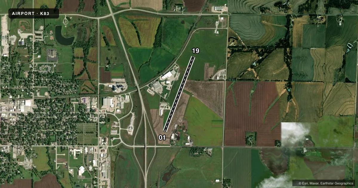
Full pagePattern entry · RWY 19
LEFT TRAFFICAirport sketch
Runways drawn to scale from FAA survey coordinates, rendered over satellite imagery. Not for navigation.
Approaches & charts
Services on the field
Fuel grades, oxygen, maintenance, ramp storage and lighting — as declared to the FAA by the airport operator.
Fuel & services
- Fuel
- 100LL
- Oxygen (bottled)
- Not available
- Oxygen (bulk)
- Not available
- Airframe repair
- Not available
- Power plant repair
- Not available
- Other services
- AGRI
Ramp & ground
- Transient storage
- Tie-down
- Hangar
- Landing fee
- No fee published
- Customs
- Not available
- Beacon schedule
- SS-SR
- Beacon
- White / Green (civil land)(WG)
- Wind indicator
- Lighted
- Segmented circle
- No
Fuel & FBOs
Cheapest 100LL and Jet A on the field and nearby. Always confirm with the FBO before taxi.
Airport notes
Surface conditions, obstructions, local procedures, lighting outages and other notes published with each FAA cycle.
General notes
- FOR CD CTC ST JOSEPH APCH AT 816-236-3035. WHEN ST JOSEPH APCH IS CLSD, CTC KANSAS CITY ARTCC AT 913-254-8508.
Fuel notes
- 100LL24 HR FUEL AVBL WITH CREDIT CARD.
Other notes
- THIS AIRPORT HAS BEEN SURVEYED BY THE NATIONAL GEODETIC SURVEY.
- CALL FOR TRANSIENT HGR AVAILABILITY.
VFR map & nearby airports
VFR sectional. Tap any ICAO chip to open that airport.
Key facts · K83
Answer card- ICAO
- K83
- Name
- SABETHA MUNI
- Location
- SABETHA, KANSAS
- Elevation
- 1,327.6 ft MSL
- Traffic pattern altitude
- 2,327.6 ft MSL (1,000 AGL)
- Control tower
- Non-towered (use CTAF)
- Total runways
- 1
- Longest runway
- 01/19 · 3,208 ft
- Published ILS approaches
- 0
- Published frequencies
- 1
- Magnetic variation
- 6°
- Current flight rules
- VFR
- Current wind
- 240° at 5 kt
- Favored runway now
- RWY 19
Sabetha Muni sits in Sabetha, Kansas. The field elevation is 1,327.6 ft MSL. It has one runway, 01/19, at 3,208 ft of asphalt. That is the longest runway on the field. The airport is not towered. CTAF is 122.9.
No ILS approaches are published here. The pattern altitude is not published, so use the standard 1,000 ft AGL unless the current Chart Supplement says otherwise. The on-field FBO is Sabetha Municipal Airport. It carries 100LL. 24-hour fuel is available with a credit card. Call ahead for transient hangar space if you need it.
For IFR work, clearance delivery goes through St Joseph Approach when it is open. When St Joseph Approach is closed, use Kansas City ARTCC. The airport has been surveyed by the National Geodetic Survey, which is useful if you are checking field data or planning a precise arrival. For a first-time stop, the key points are simple. Expect an uncontrolled field. Expect no published ILS. Expect a single short asphalt runway. Check the current Chart Supplement before you go for any changes to procedures or local remarks.