METAR & TAF K01
K01 does not publish a METAR.
Showing the nearest reporting station: KAFK (NEBRASKA CITY MUNI) · 13.7 NM away. Conditions at K01 may differ.
METAR · KAFK
Observed 21:35Z
KAFK 272135Z AUTO 07006KT 10SM CLR 35/25 A2980 RMK AO2 T03500249
- Wind
- 070° @ 6 kt
- Visibility
- 10 SM
- Temp / Dew
- 35°C / 25°C
- Altimeter
- 29.80 inHg
- Clouds
- CLR
- Density alt
- 3,695 ft
- Ceiling
- Unlimited
- Rules
- VFR
Airport info & contacts
Manager on record, flight service, ARTCC, attendance schedule and pattern altitude — published by the FAA and refreshed every 28 days.
Location
- From city
- 3 NM E
- VFR sectional
- OMAHA
- ARTCC
- ZMP · MINNEAPOLIS
- NOTAM facility
- OLU (NOTAM-D)
Airport manager
- Name
- KENDALL NEIMAN
- Phone
- 402-274-8386
- Address
- 1321 F STREET, AUBURN NE 68305
Flight service · Hours
- FSS OLU
- COLUMBUS1-800-WX-BRIEF
- Attendance
- Unattended
Frequencies
Tap any row to copy the frequency to your clipboard.
Runways & pattern
Full pagePattern entry · RWY 16
LEFT TRAFFICRunway end performance
| End | TORA | TODA | ASDA | LDA | VGSI | Approach lights | Obstruction |
|---|---|---|---|---|---|---|---|
| 16 | — | — | — | — | PAPI 2-box left(3.5°) | — | — |
| 34 | — | — | — | — | PAPI 2-box left(3°) | — | — |
Declared distances in feet. TORA = takeoff run available, TODA = takeoff distance, ASDA = accelerate-stop, LDA = landing distance.
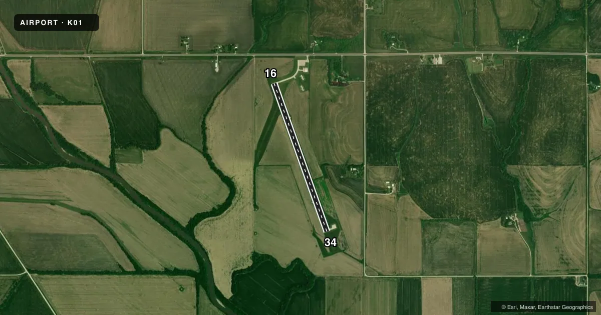
Airport sketch
Runways drawn to scale from FAA survey coordinates, rendered over satellite imagery. Not for navigation.
Approaches & charts
Services on the field
Fuel grades, oxygen, maintenance, ramp storage and lighting — as declared to the FAA by the airport operator.
Fuel & services
- Fuel
- 100LL
- Oxygen (bottled)
- Not available
- Oxygen (bulk)
- Not available
Ramp & ground
- Transient storage
- Tie-down
- Hangar
- Landing fee
- No fee published
- Customs
- Not available
- Lighting schedule
- SEE RMK
- Beacon schedule
- SS-SR
- Beacon
- White / Green (civil land)(WG)
- Wind indicator
- Lighted
Fuel & FBOs
Cheapest 100LL and Jet A on the field and nearby. Always confirm with the FBO before taxi.
Airport notes
Surface conditions, obstructions, local procedures, lighting outages and other notes published with each FAA cycle.
General notes
- FOR CD CTC MINNEAPOLIS ARTCC AT 651-463-5588.
Lighting notes
- ACTVT PAPI RWY 16 & 34; MIRL RWY 16/34 2200-0600 - CTAF.
Approach & departure obstructions
- 16FOR RWY 34: TREE 13 FT ABV, 642 FT OUT, 186 FT R, CREATES 34:1 APRCH SLOPE.
Other notes
- ARPT ESTAB PRIOR TO 1959.
- 1FOR SVC AFT HRS CALL 402-274-8386.
- OWNERADDL CITY HALL PHONE NR: 402-274-3420.
VFR map & nearby airports
VFR sectional. Tap any ICAO chip to open that airport.
Key facts · K01
Answer card- ICAO
- K01
- Name
- FARINGTON FLD
- Location
- AUBURN, NEBRASKA
- Elevation
- 924.4 ft MSL
- Traffic pattern altitude
- 1,924.4 ft MSL (1,000 AGL)
- Control tower
- Non-towered (use CTAF)
- Total runways
- 1
- Longest runway
- 16/34 · 3,750 ft
- Published ILS approaches
- 0
- Published frequencies
- 1
- Magnetic variation
- 2°
- Current flight rules
- VFR
- Current wind
- 070° at 6 kt
- Favored runway now
- RWY 16
Farington Fld sits in Auburn, Nebraska. The field elevation is 924.4 ft MSL. It has one runway, 16/34, which is 3,750 ft long with a concrete surface. There is no control tower. CTAF is 122.9.
No ILS approaches are published here. The pattern altitude is not published in the facts, so use the current Chart Supplement before you go. The runway lights on 16 and 34 are medium intensity. They operate from 2200 to 0600 on CTAF. The PAPI is activated on both runway ends.
Watch the published obstruction note for runway 34. A tree sits 642 feet out and 186 feet right of centerline. It is 13 feet above ground level. That makes the 34 approach worth a close look on short final. For after-hours service, call the number in the Chart Supplement. If you need clearance delivery, Minneapolis ARTCC is listed in the remarks. There are no on-field FBOs listed, so contact the airport operator directly or call the field on CTAF for current service details before arrival.