METAR & TAF K57
K57 does not publish a METAR.
Showing the nearest reporting station: KSDA (SHENANDOAH MUNI) · 18.5 NM away. Conditions at K57 may differ.
METAR · KSDA
Observed 21:35Z
KSDA 272135Z AUTO 15007KT 8SM 33/26 A2976 RMK AO2
- Wind
- 150° @ 7 kt
- Visibility
- 8 SM
- Temp / Dew
- 33°C / 26°C
- Altimeter
- 29.76 inHg
- Clouds
- Clear
- Density alt
- 3,494 ft
- Ceiling
- Unlimited
- Rules
- VFR
Airport info & contacts
Manager on record, flight service, ARTCC, attendance schedule and pattern altitude — published by the FAA and refreshed every 28 days.
Location
- From city
- 1 NM E
- VFR sectional
- OMAHA
- ARTCC
- ZMP · MINNEAPOLIS
- NOTAM facility
- COU (NOTAM-D)
Airport manager
- Name
- BROOKS HURST
- Phone
- 816-244-6927
- Address
- 19206 STATE HWY O, TARKIO MO 64491
Flight service · Hours
- FSS COU
- COLUMBIA1-800-WX-BRIEF
- Attendance
- Unattended
Frequencies
Tap any row to copy the frequency to your clipboard.
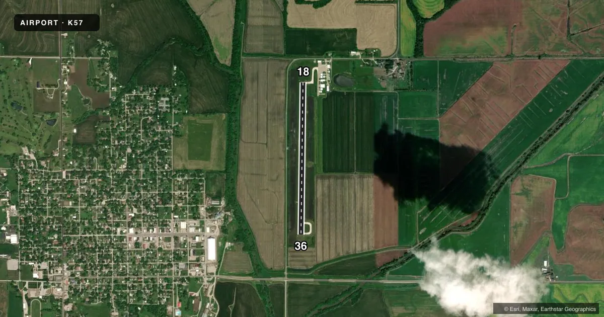
Runways & pattern
Full pagePattern entry · RWY 18
LEFT TRAFFICRunway end performance
| End | TORA | TODA | ASDA | LDA | VGSI | Approach lights | Obstruction |
|---|---|---|---|---|---|---|---|
| 18 | — | — | — | — | PAPI 2-box left(3.25°) | — | 102', tree, 1912' from thr, 324' R of cntrln, slope 16 |
| 36 | — | — | — | — | PAPI 2-box left(3°) | — | 96', tree, 1852' from thr, 491' R of cntrln, slope 17 |
Declared distances in feet. TORA = takeoff run available, TODA = takeoff distance, ASDA = accelerate-stop, LDA = landing distance.
Airport sketch
Runways drawn to scale from FAA survey coordinates, rendered over satellite imagery. Not for navigation.
Approaches & charts
Services on the field
Fuel grades, oxygen, maintenance, ramp storage and lighting — as declared to the FAA by the airport operator.
Fuel & services
- Fuel
- 100LL
- Oxygen (bottled)
- Not available
- Oxygen (bulk)
- Not available
- Airframe repair
- Minor
- Power plant repair
- Minor
- Other services
- AGRI,INSTR,RNTL
Ramp & ground
- Transient storage
- Tie-down
- Landing fee
- No fee published
- Customs
- Not available
- Lighting schedule
- SEE RMK
- Beacon schedule
- SS-SR
- Beacon
- White / Green (civil land)(WG)
- Wind indicator
- Lighted
- Segmented circle
- No
Fuel & FBOs
Cheapest 100LL and Jet A on the field and nearby. Always confirm with the FBO before taxi.
Airport notes
Surface conditions, obstructions, local procedures, lighting outages and other notes published with each FAA cycle.
General notes
- CROP DUSTING ACFT ON & INVOF ARPT.
- WILDLIFE ON & INVOF ARPT.
- FOR CD CTC MINNEAPOLIS ARTCC AT 651-463-5588.
Lighting notes
- TO INCR INTST & ACTVT REIL RWY 18 & 36; MIRL RWY 18/36 - CTAF.
Runway surface & condition
- 18/36PCR VALUE: 61/R/D/W/T
Other notes
- EXISTED PRIOR TO 1959.
VFR map & nearby airports
VFR sectional. Tap any ICAO chip to open that airport.
Key facts · K57
Answer card- ICAO
- K57
- Name
- GOULD PETERSON MUNI
- Location
- TARKIO, MISSOURI
- Elevation
- 915.6 ft MSL
- Traffic pattern altitude
- 1,915.6 ft MSL (1,000 AGL)
- Control tower
- Non-towered (use CTAF)
- Total runways
- 1
- Longest runway
- 18/36 · 3,600 ft
- Published ILS approaches
- 0
- Published frequencies
- 1
- Magnetic variation
- 3°
- Current flight rules
- VFR
- Current wind
- 150° at 7 kt
- Favored runway now
- RWY 18
Gould Peterson Muni sits in Tarkio, Missouri. The field elevation is 915.6 ft MSL. It has one runway, 18/36, at 3,600 ft of concrete. The airport is not towered. CTAF is 122.9. No ILS approaches are published here.
The pattern altitude is not published, so plan on the standard 1,000 ft AGL unless the current Chart Supplement says otherwise. That puts the pattern at about 1,916 ft MSL based on the field elevation. Wingnuts Flying Circus is on the field. It carries 100LL. Call them at (816) 244-6927 for current service details before you go.
A few operational items matter here. Wildlife is present on and near the airport. Crop dusting aircraft also operate on and in the vicinity of the field. The runway lighting is activated on CTAF. Use the radio to bring up the runway end identifier lights and the medium intensity runway lights for 18/36. The pavement rating is 61 rigid dual wheel tandem. For clearance delivery, Minneapolis ARTCC is the published contact. If you need a clearance or want current airport details, verify with the current FAA Chart Supplement or call the airport operator directly.