METAR & TAF KEVU
Current METAR
Observed 19:35Z
KEVU 231935Z AUTO 17007KT 10SM BKN043 24/17 A3015 RMK AO2 T02410176
- Wind
- 170° @ 7 kt
- Visibility
- 10 SM
- Temp / Dew
- 24°C / 17°C
- Altimeter
- 30.15 inHg
- Clouds
- BKN
- Density alt
- 2,215 ft
- Ceiling
- 4,300 ft AGL
- Rules
- VFR
Airport info & contacts
Manager on record, flight service, ARTCC, attendance schedule and pattern altitude — published by the FAA and refreshed every 28 days.
Location
- From city
- 2 NM W
- VFR sectional
- OMAHA
- ARTCC
- ZMP · MINNEAPOLIS
- NOTAM facility
- COU (NOTAM-D)
Airport manager
- Name
- CHUCK HARROUN
- Phone
- 660-582-2233
- Address
- 25775 HAWK RD, MARYVILLE MO 64468
Flight service · Hours
- FSS COU
- COLUMBIA1-800-WX-BRIEF
- Attendance
- 0800-1900
Frequencies
Tap any row to copy the frequency to your clipboard.
Runways & pattern
Full pagePattern entry · RWY 14
LEFT TRAFFICRunway end performance
| End | TORA | TODA | ASDA | LDA | VGSI | Approach lights | Obstruction |
|---|---|---|---|---|---|---|---|
| 14 | — | — | — | — | PAPI 4-box left(3°) | — | — |
| 32 | — | — | — | — | PAPI 4-box left(3°) | — | — |
Declared distances in feet. TORA = takeoff run available, TODA = takeoff distance, ASDA = accelerate-stop, LDA = landing distance.
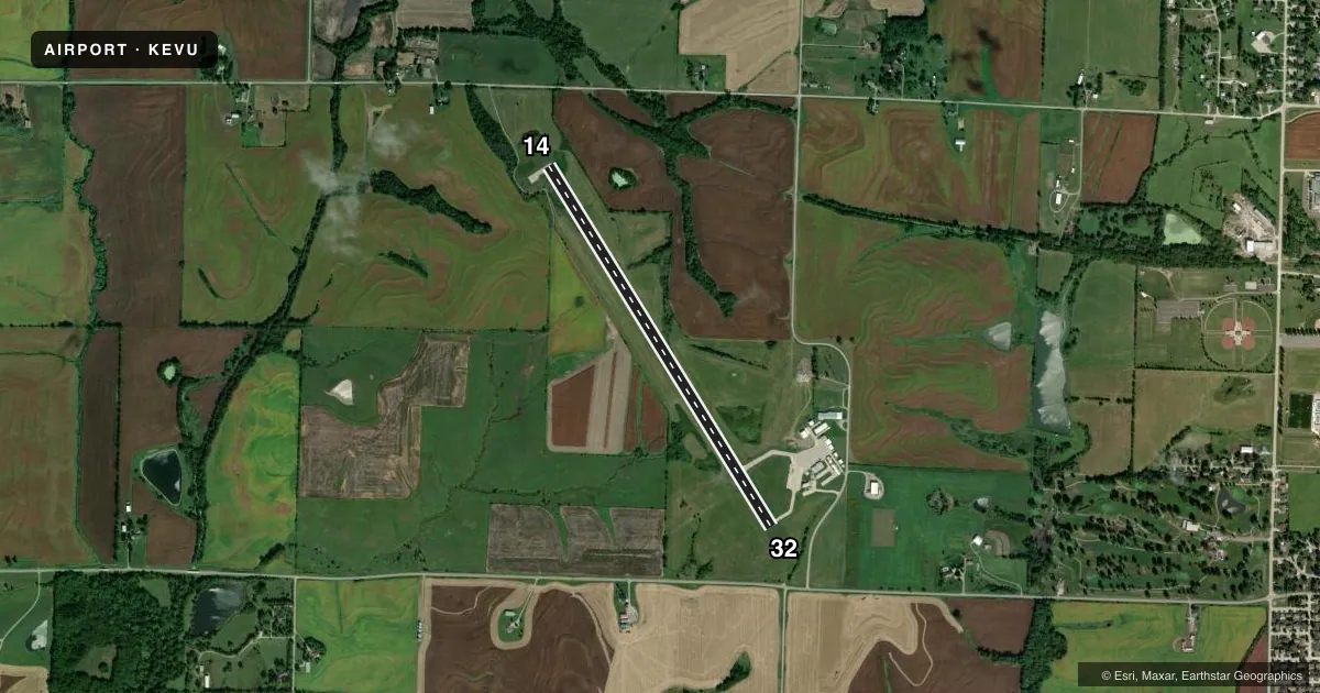
Airport sketch
Runways drawn to scale from FAA survey coordinates, rendered over satellite imagery. Not for navigation.
Approaches & charts
Services on the field
Fuel grades, oxygen, maintenance, ramp storage and lighting — as declared to the FAA by the airport operator.
Fuel & services
- Fuel
- 100LLA+
- Oxygen (bottled)
- Not available
- Oxygen (bulk)
- Not available
- Airframe repair
- Not available
- Power plant repair
- Not available
- Other services
- INSTR,RNTL
Ramp & ground
- Transient storage
- Tie-down
- Landing fee
- No fee published
- Customs
- Not available
- Lighting schedule
- SEE RMK
- Beacon schedule
- SS-SR
- Beacon
- White / Green (civil land)(WG)
- Wind indicator
- Lighted
- Segmented circle
- No
Fuel & FBOs
Cheapest 100LL and Jet A on the field and nearby. Always confirm with the FBO before taxi.
Airport notes
Surface conditions, obstructions, local procedures, lighting outages and other notes published with each FAA cycle.
General notes
- FOR CD CTC MINNEAPOLIS ARTCC AT 651-463-5588.
Lighting notes
- MIRL RY 14/32 PRESET ON LOW INTST; TO INCR INTST & ACTVT REIL AND PAPI RYS 14 & 32 - CTAF.
Other notes
- PRVDD APCH SLOPES ARE MAINTD FOR A 20:1 & TRSNL SFC 7:1.
- MANAGERALTERNATE PHONE NUMBER 660-562-8001.
VFR map & nearby airports
VFR sectional. Tap any ICAO chip to open that airport.
Key facts · KEVU
Answer card- ICAO
- KEVU
- Name
- NORTHWEST MISSOURI RGNL
- Location
- MARYVILLE, MISSOURI
- Elevation
- 1,145.2 ft MSL
- Traffic pattern altitude
- 2,145.2 ft MSL (1,000 AGL)
- Control tower
- Non-towered (use CTAF)
- Total runways
- 1
- Longest runway
- 14/32 · 4,600 ft
- Published ILS approaches
- 0
- Published frequencies
- 2
- Magnetic variation
- 1°
- Current flight rules
- VFR
- Current wind
- 170° at 7 kt
- Favored runway now
- RWY 14
Northwest Missouri Regional Airport sits in Maryville, Missouri. Field elevation is 1,145.2 ft MSL. The airport has one runway. Runway 14/32 is 4,600 ft long with concrete pavement. There is no control tower, so expect self-announce traffic on CTAF 122.8. The published pattern altitude is not listed. Use the standard 1,000 ft AGL pattern for light piston operations unless the current Chart Supplement says otherwise.
No ILS approaches are published here. That matters if the weather is marginal or if you want an instrument backup. The on-field FBO is Northwest Missouri Regional Airport. It carries 100LL and Jet A Prist. Call (660) 582-2233 for current service details. An alternate number is 660-562-8001.
The runway lights on 14/32 are preset to low intensity. Use CTAF to increase intensity. That also activates the runway end identifier lights and the precision approach path indicators for runways 14 and 32. Clearance delivery is handled through Minneapolis ARTCC at 651-463-5588. The field also has published slope notes for nearby surfaces. If you are planning a night or low-visibility arrival, verify the current Chart Supplement before you go. This is a non-towered field with a single runway, so keep your scan tight and expect local traffic calls on 122.8.