METAR & TAF KSDA
Current METAR
Observed 21:35Z
KSDA 272135Z AUTO 15007KT 8SM 33/26 A2976 RMK AO2
- Wind
- 150° @ 7 kt
- Visibility
- 8 SM
- Temp / Dew
- 33°C / 26°C
- Altimeter
- 29.76 inHg
- Clouds
- Clear
- Density alt
- 3,563 ft
- Ceiling
- Unlimited
- Rules
- VFR
Airport info & contacts
Manager on record, flight service, ARTCC, attendance schedule and pattern altitude — published by the FAA and refreshed every 28 days.
Location
- From city
- 3 NM SW
- VFR sectional
- OMAHA
- ARTCC
- ZMP · MINNEAPOLIS
- NOTAM facility
- SDA (NOTAM-D)
Airport manager
- Name
- RANDY WAGNER
- Phone
- 712-246-1931
- Address
- 2033 MANTI ROAD, SHENANDOAH IA 51601
Flight service · Hours
- FSS FOD
- FORT DODGE1-800-WX-BRIEF
- Attendance
- MON - SAT · 0800-1700
Frequencies
Tap any row to copy the frequency to your clipboard.
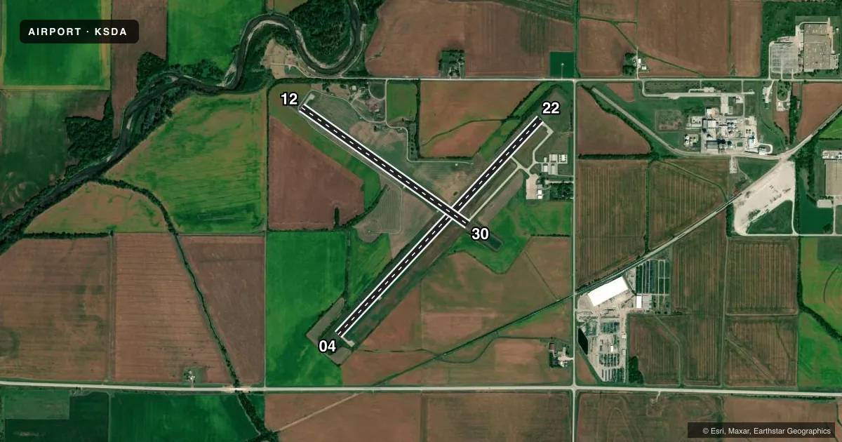
Runways & pattern
Full pagePattern entry · RWY 12
LEFT TRAFFIC| Runway | Heading (°M) | Length | Surface | Traffic |
|---|---|---|---|---|
| 04/22 | 38° / 218° | 5,000 ft | CONC | Standard L |
| 12/30Favored | 120° / 300° | 3,439 ft | CONC | Standard L |
Runway end performance
| End | TORA | TODA | ASDA | LDA | VGSI | Approach lights | Obstruction |
|---|---|---|---|---|---|---|---|
| 04 | — | — | — | — | PAPI 2-box left(3°) | — | 15', brush, 225' from thr, 163' R of cntrln, slope 1 |
| 22 | — | — | — | — | PAPI 2-box left(3°) | — | 10', brush, 210' from thr, 160' R of cntrln, slope 1 |
| 12 | — | — | — | — | — | — | 23', trees, 568' from thr, 138' R of cntrln, slope 16 |
| 30 | — | — | — | — | VASI 4-box left(3.5°) | — | 23', trees, 262' from thr, 113' R of cntrln, slope 2 |
Declared distances in feet. TORA = takeoff run available, TODA = takeoff distance, ASDA = accelerate-stop, LDA = landing distance.
Airport sketch
Runways drawn to scale from FAA survey coordinates, rendered over satellite imagery. Not for navigation.
Approaches & charts
Services on the field
Fuel grades, oxygen, maintenance, ramp storage and lighting — as declared to the FAA by the airport operator.
Fuel & services
- Fuel
- 100LLA+
- Oxygen (bottled)
- Not available
- Oxygen (bulk)
- Not available
- Airframe repair
- Major
- Power plant repair
- Major
- Other services
- AGRI
Ramp & ground
- Transient storage
- Tie-down
- Hangar
- Landing fee
- No fee published
- Customs
- Not available
- Lighting schedule
- SEE RMK
- Beacon schedule
- SS-SR
- Beacon
- White / Green (civil land)(WG)
- Wind indicator
- Lighted
- Segmented circle
- Yes
Fuel & FBOs
Cheapest 100LL and Jet A on the field and nearby. Always confirm with the FBO before taxi.
Airport notes
Surface conditions, obstructions, local procedures, lighting outages and other notes published with each FAA cycle.
General notes
- RY 22 IS CALM WIND RY.
- FOR CD CTC OMAHA APCH AT 402-682-4395.
Lighting notes
- ACTVT MIRL RY 04/22; PAPI RYS 04 & 22; VASI RY 30; REIL RYS 04 & 22 - CTAF.
Approach & departure obstructions
- 0424 FT TREE 30 FT FM RWY END 168 FT RIGHT ON APCH 1:1 APCH SLP.
- 12ACCESS ROAD 40 FT FM RWY END ON RWY CENTERLINE 1:1.
- 2210 FT TREE 10 FT FM RWY END 175 FT RIGHT ON APCH 1:1 APCH SLP.
Other notes
- 1FOR ATTENDANT AFT HRS CALL (712) 370-2367.
- OWNERAJ LYMAN- CITY MGR PHONE 712-246-4411.
VFR map & nearby airports
VFR sectional. Tap any ICAO chip to open that airport.
Key facts · KSDA
Answer card- ICAO
- KSDA
- Name
- SHENANDOAH MUNI
- Location
- SHENANDOAH, IOWA
- Elevation
- 971.1 ft MSL
- Traffic pattern altitude
- 1,971.1 ft MSL (1,000 AGL)
- Control tower
- Non-towered (use CTAF)
- Total runways
- 2
- Longest runway
- 04/22 · 5,000 ft
- Published ILS approaches
- 0
- Published frequencies
- 4
- Magnetic variation
- 5°
- Current flight rules
- VFR
- Current wind
- 150° at 7 kt
- Favored runway now
- RWY 12
Shenandoah Muni sits in Shenandoah, Iowa. Field elevation is 971.1 ft MSL. The airport has two concrete runways. The longest is 5,000 ft on runway 04/22. There is no control tower. CTAF and UNICOM are both 122.8. No ILS approaches are published here.
For pattern work, the published pattern altitude is not listed. Use the standard 1,000 ft AGL pattern unless the current FAA Chart Supplement says otherwise. Omaha Approach handles approach and departure services on 124.5 and 263.0. Clearance delivery is also handled through Omaha Approach. Runway 22 is the calm wind runway. Medium intensity runway lights are on runway 04/22. PAPI is available on runways 04 and 22. VASI is available on runway 30. REILs are on runways 04 and 22.
The on-field FBO is Shenandoah Municipal Airport. It carries 100LL and Jet A with Prist. After hours, call the attendant number in the Chart Supplement or the airport directly. First-time visitors should pay attention to the published obstacle notes near the runway ends. Runway 04 has a tree close to the departure end. Runway 22 has a tree close to the departure end too. Runway 12 also has an access road near the end on centerline. This is a non-towered field, so standard CTAF discipline matters.