METAR & TAF 0G3
0G3 does not publish a METAR.
Showing the nearest reporting station: KAFK (NEBRASKA CITY MUNI) · 18.6 NM away. Conditions at 0G3 may differ.
METAR · KAFK
Observed 16:55Z
KAFK 271655Z AUTO 22007KT 10SM CLR 33/23 A2979 RMK AO2 T03310230
- Wind
- 220° @ 7 kt
- Visibility
- 10 SM
- Temp / Dew
- 33°C / 23°C
- Altimeter
- 29.79 inHg
- Clouds
- CLR
- Density alt
- 3,941 ft
- Ceiling
- Unlimited
- Rules
- VFR
Airport info & contacts
Manager on record, flight service, ARTCC, attendance schedule and pattern altitude — published by the FAA and refreshed every 28 days.
Location
- From city
- 2 NM NE
- VFR sectional
- OMAHA
- ARTCC
- ZMP · MINNEAPOLIS
- NOTAM facility
- OLU (NOTAM-D)
Airport manager
- Name
- MIKE WENDT
- Phone
- 402-335-3303
- Address
- PO BOX 537, TECUMSEH NE 68450-0537
Flight service · Hours
- FSS OLU
- COLUMBUS1-800-WX-BRIEF
- Attendance
- Unattended
Frequencies
Tap any row to copy the frequency to your clipboard.
Runways & pattern
Full pagePattern entry · RWY 15
LEFT TRAFFICRunway end performance
| End | TORA | TODA | ASDA | LDA | VGSI | Approach lights | Obstruction |
|---|---|---|---|---|---|---|---|
| 15 | — | — | — | — | PAPI 2-box left(3°) | — | — |
| 33 | — | — | — | — | PAPI 2-box left(3°) | — | — |
Declared distances in feet. TORA = takeoff run available, TODA = takeoff distance, ASDA = accelerate-stop, LDA = landing distance.
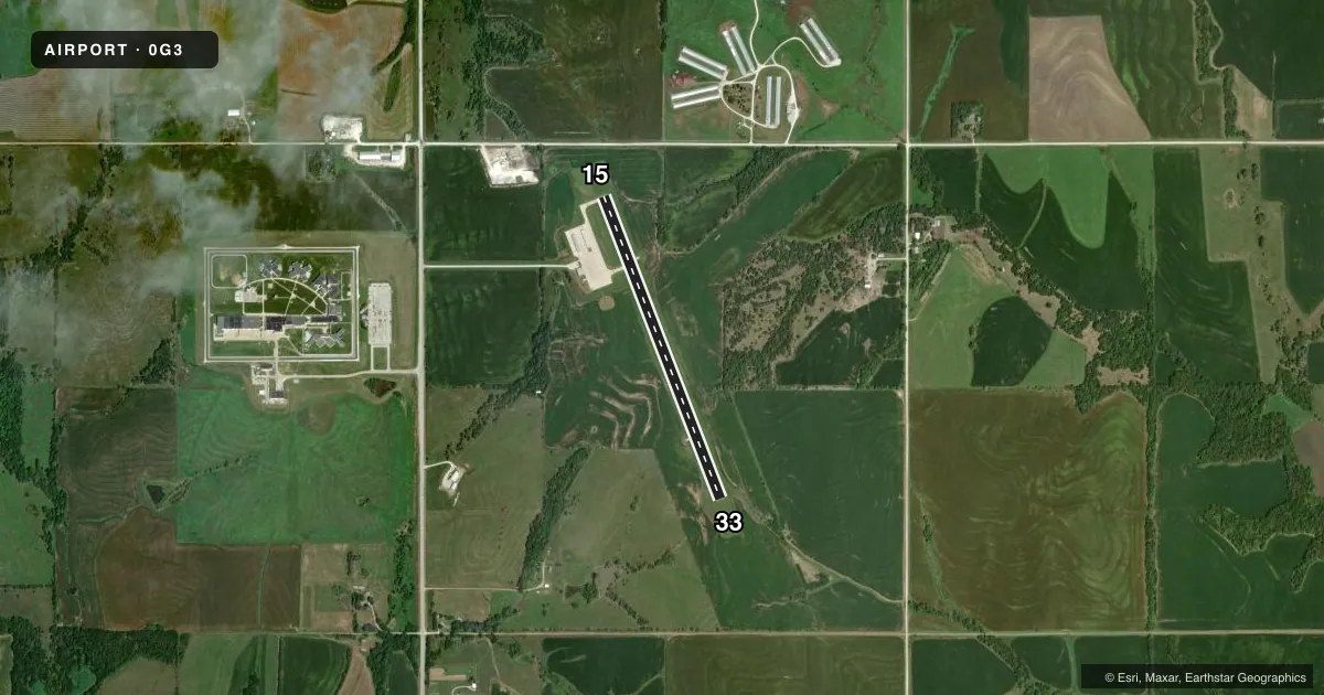
Airport sketch
Runways drawn to scale from FAA survey coordinates, rendered over satellite imagery. Not for navigation.
Approaches & charts
Services on the field
Fuel grades, oxygen, maintenance, ramp storage and lighting — as declared to the FAA by the airport operator.
Fuel & services
- Fuel
- 100LL
- Oxygen (bottled)
- Not available
- Oxygen (bulk)
- Not available
- Airframe repair
- Not available
- Power plant repair
- Not available
- Other services
- INSTR
Ramp & ground
- Transient storage
- Tie-down
- Hangar
- Landing fee
- No fee published
- Lighting schedule
- SEE RMK
- Beacon schedule
- SS-SR
- Beacon
- White / Green (civil land)(WG)
- Wind indicator
- Lighted
- Segmented circle
- No
Fuel & FBOs
Cheapest 100LL and Jet A on the field and nearby. Always confirm with the FBO before taxi.
Airport notes
Surface conditions, obstructions, local procedures, lighting outages and other notes published with each FAA cycle.
General notes
- FOR CD CTC MINNEAPOLIS ARTCC AT 651-463-5588.
- COURTESY CAR AVBL.
Lighting notes
- ACTVT REIL RWY 15 & 33; MIRL RWY 15/33; PAPI RWY 15 & 33 - CTAF.
Fuel notes
- 100LLFUEL AVBL 24 HR WITH CREDIT CARD.
Approach & departure obstructions
- 33RWY 33 REILS TEMPOLY INOPERATIVE.
Other notes
- OWNERPHIL JUILFS- CHAIRMAN.
VFR map & nearby airports
VFR sectional. Tap any ICAO chip to open that airport.
Key facts · 0G3
Answer card- ICAO
- 0G3
- Name
- TECUMSEH MUNI
- Location
- TECUMSEH, NEBRASKA
- Elevation
- 1,306.1 ft MSL
- Traffic pattern altitude
- 2,306.1 ft MSL (1,000 AGL)
- Control tower
- Non-towered (use CTAF)
- Total runways
- 1
- Longest runway
- 15/33 · 3,501 ft
- Published ILS approaches
- 0
- Published frequencies
- 1
- Magnetic variation
- 3°
- Current flight rules
- VFR
- Current wind
- 220° at 7 kt
- Favored runway now
- RWY 15
Tecumseh Muni (0G3) sits in Tecumseh, Nebraska. The field elevation is 1,306.1 ft MSL. It has one runway, 15/33, which is 3,501 ft long with a concrete surface. The airport is unattended by a control tower. CTAF is 122.9.
No ILS approaches are published here. Pattern altitude is not published, so verify the current traffic pattern in the FAA Chart Supplement before you go. The runway lighting is useful after dark. Runway end identifier lights are installed on 15 and 33. Medium intensity runway lights are also on both ends. PAPI is available on 15 and 33 and is controlled by CTAF. Note that the runway 33 REILs are temporarily inoperative.
Tecumseh Municipal Airport is on the field and carries 100LL. Fuel is available 24 hours with credit card. A courtesy car is also available. For clearance delivery, contact Minneapolis ARTCC at 651-463-5588. This is a small non-towered field, so plan for self-announce traffic and standard light-aircraft pattern work. If you are arriving IFR or need current operational detail, check the current FAA Chart Supplement or call the airport operator directly.