METAR & TAF KBIE
Current METAR
Observed 18:15Z
KBIE 271815Z AUTO 22005KT 10SM CLR 36/21 A2978 RMK AO2 T03570207
- Wind
- 220° @ 5 kt
- Visibility
- 10 SM
- Temp / Dew
- 36°C / 21°C
- Altimeter
- 29.78 inHg
- Clouds
- CLR
- Density alt
- 4,335 ft
- Ceiling
- Unlimited
- Rules
- VFR
Airport info & contacts
Manager on record, flight service, ARTCC, attendance schedule and pattern altitude — published by the FAA and refreshed every 28 days.
Location
- From city
- 3 NM N
- VFR sectional
- OMAHA
- ARTCC
- ZMP · MINNEAPOLIS
- NOTAM facility
- BIE (NOTAM-D)
Airport manager
- Name
- DENNIS SCHMITT
- Phone
- 402-223-5349
- Address
- P.O. BOX 277, BEATRICE NE 68310-0277
Flight service · Hours
- FSS OLU
- COLUMBUS1-800-WX-BRIEF
- Attendance
- 0700-1900
Frequencies
Tap any row to copy the frequency to your clipboard.
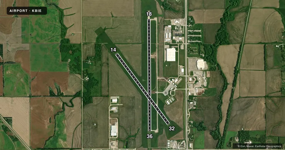
Runways & pattern
Full pagePattern entry · RWY 18
LEFT TRAFFIC| Runway | Heading (°M) | Length | Surface | Traffic |
|---|---|---|---|---|
| 18/36Favored | 176° / 356° | 5,602 ft | CONC | Standard L |
| 14/32 | 139° / 319° | 4,401 ft | CONC | Standard L |
Runway end performance
| End | TORA | TODA | ASDA | LDA | VGSI | Approach lights | Obstruction |
|---|---|---|---|---|---|---|---|
| 18 | 5,602' | 5,602' | 5,602' | 5,602' | — | — | — |
| 36 | 5,602' | 5,602' | 6,002' | 5,602' | PAPI 2-box left(3°) | MALSR | — |
Declared distances in feet. TORA = takeoff run available, TODA = takeoff distance, ASDA = accelerate-stop, LDA = landing distance.
Airport sketch
Runways drawn to scale from FAA survey coordinates, rendered over satellite imagery. Not for navigation.
Approaches & charts
Services on the field
Fuel grades, oxygen, maintenance, ramp storage and lighting — as declared to the FAA by the airport operator.
Fuel & services
- Fuel
- 100LLA
- Oxygen (bottled)
- Not available
- Oxygen (bulk)
- Not available
- Airframe repair
- Minor
- Power plant repair
- Minor
- Other services
- AFRT,AGRI,INSTR,RNTL
Ramp & ground
- Transient storage
- Tie-down
- Hangar
- Landing fee
- No fee published
- Customs
- Not available
- Lighting schedule
- SEE RMK
- Beacon schedule
- SS-SR
- Beacon
- White / Green (civil land)(WG)
- Wind indicator
- Lighted
- Segmented circle
- Yes
Fuel & FBOs
Cheapest 100LL and Jet A on the field and nearby. Always confirm with the FBO before taxi.
Airport notes
Surface conditions, obstructions, local procedures, lighting outages and other notes published with each FAA cycle.
General notes
- RWY 18 IS DESIGNATED AS THE CALM WIND RWY.
- 400' STOPWAY AT RWY 36 DER.
- FOR CD IF UNA TO CTC ON FSS FREQ, CTC MINNEAPOLIS ARTCC AT 651-463-5588.
Lighting notes
- ACTVT MALSR RWY 36; REIL RWY 14 & 32 - CTAF. MIRL RWY 14/32 & RWY 18/36 OPR SS-SR. PAPI RWY 36 OPR CONSLY.
Fuel notes
- 100LL24 HR SELF SVC FUEL AVBL VIA CREDIT CARD SYSTEM & FOR JET A FUEL SVC AFT HRS CALL 913-433-4671 OR 541-668-1561.
- AJET A FUEL SVC AFT HRS CALL 913-433-4671 OR 541-668-1561.
Other notes
- CTC ARPT REG HNGR AVBLITY.
- 1WINTER HOURS 0700-1800
- 1FOR SVC AFT HRS CALL 913-433-4671 OR 541-668-1561.
VFR map & nearby airports
VFR sectional. Tap any ICAO chip to open that airport.
Key facts · KBIE
Answer card- ICAO
- KBIE
- Name
- BEATRICE MUNI
- Location
- BEATRICE, NEBRASKA
- Elevation
- 1,323.6 ft MSL
- Traffic pattern altitude
- 2,323.6 ft MSL (1,000 AGL)
- Control tower
- Non-towered (use CTAF)
- Total runways
- 2
- Longest runway
- 18/36 · 5,602 ft
- Published ILS approaches
- 0
- Published frequencies
- 2
- Magnetic variation
- 4°
- Current flight rules
- VFR
- Current wind
- 220° at 5 kt
- Favored runway now
- RWY 18
Beatrice Muni sits in Beatrice, Nebraska. The field elevation is 1,323.6 ft MSL. It has two concrete runways. The longest is runway 18/36 at 5,602 ft. There is no control tower. CTAF and UNICOM are both 122.8. No ILS approaches are published here.
The pattern altitude is not published. Use the standard 1,000 ft AGL pattern unless local procedures or the current Chart Supplement say otherwise. Runway 36 has MALSR lighting. Runways 14 and 32 have REIL. Medium intensity runway lights on both runways run from sunset to sunrise. PAPI on runway 36 operates continuously. Runway 18 is the calm wind runway.
The on-field FBO is Beatrice Municipal Airport. It carries 100LL and Jet A Prist. 24-hour self-serve 100LL is available by credit card. After-hours Jet A service is available by phone. For a first-time arrival, pay attention to the stopway at the departure end of runway 36. Winter hours are 0700 to 1800. If you need hangar space, contact the airport about availability before you go.