METAR & TAF KSWT
KSWT does not publish a METAR.
Showing the nearest reporting station: KLNK (LINCOLN) · 15.9 NM away. Conditions at KSWT may differ.
METAR · KLNK
Observed 16:54Z
KLNK 271654Z 00000KT 10SM CLR 34/21 A2979 RMK AO2 SLP070 T03390211
- Wind
- 000° @ 0 kt
- Visibility
- 10 SM
- Temp / Dew
- 34°C / 21°C
- Altimeter
- 29.79 inHg
- Clouds
- CLR
- Density alt
- 4,308 ft
- Ceiling
- Unlimited
- Rules
- VFR
Airport info & contacts
Manager on record, flight service, ARTCC, attendance schedule and pattern altitude — published by the FAA and refreshed every 28 days.
Location
- From city
- 3 NM S
- VFR sectional
- OMAHA
- ARTCC
- ZMP · MINNEAPOLIS
- NOTAM facility
- OLU (NOTAM-D)
Airport manager
- Name
- GREG AND TERRI WHISLER
- Phone
- 402-643-2125
- Address
- BOX 278, SEWARD NE 68434-0278
Flight service · Hours
- FSS OLU
- COLUMBUS1-800-WX-BRIEF
- Attendance
- MON-SAT · 0800-1700
Frequencies
Tap any row to copy the frequency to your clipboard.
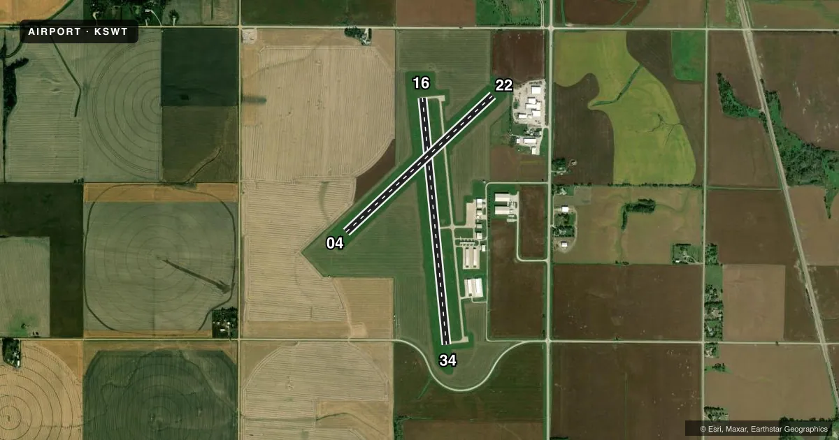
Runways & pattern
Full pagePattern entry · RWY 16
LEFT TRAFFIC| Runway | Heading (°M) | Length | Surface | Traffic |
|---|---|---|---|---|
| 16/34 | 168° / 348° | 4,200 ft | CONC | Standard L |
| 04/22 | 41° / 221° | 3,400 ft | TURF | Standard L |
Runway end performance
| End | TORA | TODA | ASDA | LDA | VGSI | Approach lights | Obstruction |
|---|---|---|---|---|---|---|---|
| 16 | — | — | — | — | PAPI 2-box left(3°) | — | — |
| 34 | — | — | — | — | PAPI 2-box left(3°) | — | — |
Declared distances in feet. TORA = takeoff run available, TODA = takeoff distance, ASDA = accelerate-stop, LDA = landing distance.
Airport sketch
Runways drawn to scale from FAA survey coordinates, rendered over satellite imagery. Not for navigation.
Approaches & charts
Services on the field
Fuel grades, oxygen, maintenance, ramp storage and lighting — as declared to the FAA by the airport operator.
Fuel & services
- Fuel
- 100LLA
- Oxygen (bottled)
- Not available
- Oxygen (bulk)
- Not available
- Airframe repair
- Major
- Power plant repair
- Major
Ramp & ground
- Transient storage
- Tie-down
- Hangar
- Landing fee
- No fee published
- Customs
- Not available
- Lighting schedule
- SEE RMK
- Beacon schedule
- SS-SR
- Beacon
- White / Green (civil land)(WG)
- Wind indicator
- Lighted
- Segmented circle
- No
Fuel & FBOs
Cheapest 100LL and Jet A on the field and nearby. Always confirm with the FBO before taxi.
Airport notes
Surface conditions, obstructions, local procedures, lighting outages and other notes published with each FAA cycle.
General notes
- FOR CD CTC OMAHA APCH AT 402-682-4395.
Lighting notes
- ACTVT MIRL RWY 16/34; PAPI RWY 16 & 34; WINDSOCK - CTAF.
Fuel notes
- 100LLSELF SVC AVBL H24.
Approach & departure obstructions
- 1623 FT ROAD 1225 FT FM RWY END XS CNTRLN.
- 3413 FT ROAD 730 FT FM RWY END XS CNTRLN.
Other notes
- OWNERMARVIN SIEFERT, AIRPORT AUTHORITY CHAIRMAN.
VFR map & nearby airports
VFR sectional. Tap any ICAO chip to open that airport.
Key facts · KSWT
Answer card- ICAO
- KSWT
- Name
- SEWARD MUNI
- Location
- SEWARD, NEBRASKA
- Elevation
- 1,505.5 ft MSL
- Traffic pattern altitude
- 2,505.5 ft MSL (1,000 AGL)
- Control tower
- Non-towered (use CTAF)
- Total runways
- 2
- Longest runway
- 16/34 · 4,200 ft
- Published ILS approaches
- 0
- Published frequencies
- 4
- Magnetic variation
- 6°
- Current flight rules
- VFR
- Current wind
- 000° at 0 kt
- Favored runway now
- –
Seward Muni sits in Seward, Nebraska. The field elevation is 1,505.5 ft MSL. It has two runways. The longest is 4,200 ft of concrete on 16/34. The turf runway is 3,400 ft on 04/22. There is no control tower. Pattern altitude is not published, so use standard 1,000 ft AGL for light piston traffic unless the current Chart Supplement says otherwise.
No ILS approaches are published here. CTAF and UNICOM are both 122.8. Omaha Approach handles approach and departure services on 124.0 and 270.3. For clearance delivery, contact Omaha Approach at 402-682-4395. Whisler Aviation is on the field. It carries 100LL and Jet A with Prist. Self-serve 100LL is available 24 hours a day.
A few published remarks matter for planning. There is a road crossing the runway centerline near both ends of 16/34, so pay attention on rollout and during takeoff. Medium intensity runway lights are on 16/34. PAPI is installed on 16 and 34. The airport sits in open country with modest elevation, so density altitude can still matter on warm Nebraska days. Check the current Chart Supplement for any changes before you go.