METAR & TAF KAHQ
Current METAR
Observed 16:35Z
KAHQ 271635Z AUTO 03005KT 10SM CLR 33/22 A2979 RMK AO2 T03290217
- Wind
- 030° @ 5 kt
- Visibility
- 10 SM
- Temp / Dew
- 33°C / 22°C
- Altimeter
- 29.79 inHg
- Clouds
- CLR
- Density alt
- 3,841 ft
- Ceiling
- Unlimited
- Rules
- VFR
Airport info & contacts
Manager on record, flight service, ARTCC, attendance schedule and pattern altitude — published by the FAA and refreshed every 28 days.
Location
- From city
- 2 NM NE
- VFR sectional
- OMAHA
- ARTCC
- ZMP · MINNEAPOLIS
- NOTAM facility
- OLU (NOTAM-D)
Airport manager
- Name
- CHRISTINA FASEL
- Phone
- 402-443-3222
- Address
- WAHOO NE 68066-0122
Flight service · Hours
- FSS OLU
- COLUMBUS1-800-WX-BRIEF
- Attendance
- DAWN-DUSK
Frequencies
Tap any row to copy the frequency to your clipboard.
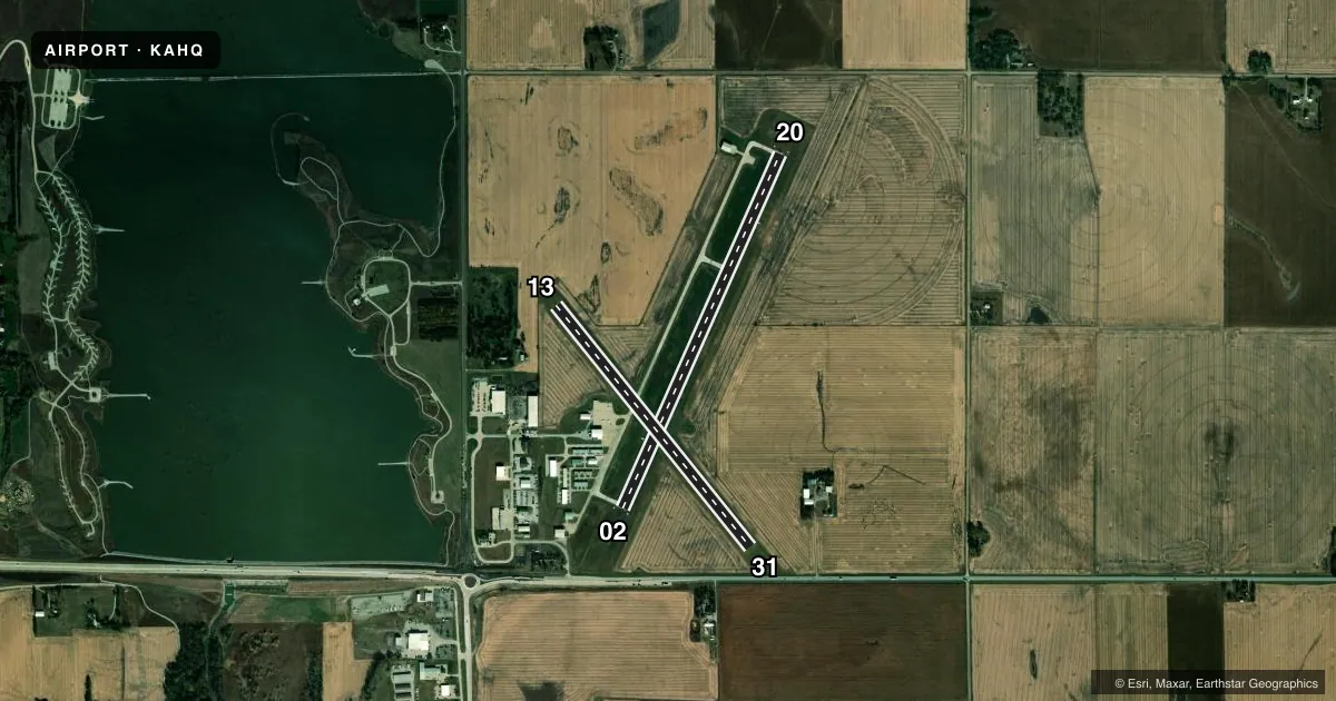
Runways & pattern
Full pagePattern entry · RWY 02
LEFT TRAFFIC| Runway | Heading (°M) | Length | Surface | Traffic |
|---|---|---|---|---|
| 02/20Favored | 18° / 198° | 4,100 ft | CONC | Standard L |
| 13/31 | 135° / 315° | 3,281 ft | TURF | Standard L |
Runway end performance
| End | TORA | TODA | ASDA | LDA | VGSI | Approach lights | Obstruction |
|---|---|---|---|---|---|---|---|
| 02 | — | — | — | — | PAPI 2-box left(3°) | — | — |
| 20 | — | — | — | — | PAPI 2-box left(3°) | — | — |
Declared distances in feet. TORA = takeoff run available, TODA = takeoff distance, ASDA = accelerate-stop, LDA = landing distance.
Airport sketch
Runways drawn to scale from FAA survey coordinates, rendered over satellite imagery. Not for navigation.
Approaches & charts
Services on the field
Fuel grades, oxygen, maintenance, ramp storage and lighting — as declared to the FAA by the airport operator.
Fuel & services
- Fuel
- 100LLA
- Oxygen (bottled)
- Not available
- Oxygen (bulk)
- Not available
- Airframe repair
- Major
- Power plant repair
- Major
- Other services
- AGRI,INSTR,SURV
Ramp & ground
- Transient storage
- Tie-down
- Hangar
- Landing fee
- No fee published
- Customs
- Not available
- Lighting schedule
- SEE RMK
- Beacon schedule
- SS-SR
- Beacon
- White / Green (civil land)(WG)
- Wind indicator
- Lighted
- Segmented circle
- Yes
Fuel & FBOs
Cheapest 100LL and Jet A on the field and nearby. Always confirm with the FBO before taxi.
Airport notes
Surface conditions, obstructions, local procedures, lighting outages and other notes published with each FAA cycle.
General notes
- RY 13/31 NOT PLOWED WINTER MONTHS.
- FOR CD CTC OMAHA APCH AT 402-682-4395.
Lighting notes
- ACTVT REIL RWY 02 & 20; PAPI RWY 02 & 20; MIRL 02/20 - CTAF.
Fuel notes
- 100LLFUEL AVBL H24 SELF SVC.
Approach & departure obstructions
- 02RWY 02 HWY 850 FT FM END 0B ALSO 36:1.
- 02ELEVATOR LEG.
Other notes
- 1FOR SVC AFT DUSK CALL 402-882-2717.
- OWNERBRIAN HOMES - ARPT AUTH CHAIRMAN.
VFR map & nearby airports
VFR sectional. Tap any ICAO chip to open that airport.
Key facts · KAHQ
Answer card- ICAO
- KAHQ
- Name
- WAHOO MUNI
- Location
- WAHOO, NEBRASKA
- Elevation
- 1,225.6 ft MSL
- Traffic pattern altitude
- 2,225.6 ft MSL (1,000 AGL)
- Control tower
- Non-towered (use CTAF)
- Total runways
- 2
- Longest runway
- 02/20 · 4,100 ft
- Published ILS approaches
- 0
- Published frequencies
- 4
- Magnetic variation
- 6°
- Current flight rules
- VFR
- Current wind
- 030° at 5 kt
- Favored runway now
- RWY 02
Wahoo Muni sits in Wahoo, Nebraska. Field elevation is 1,225.6 ft MSL. The airport has 2 runways. The longest is 4,100 ft of concrete on 02/20. The field is non-towered. CTAF and UNICOM are both 122.7. No ILS approaches are published here.
Pattern altitude is not published. For light piston traffic, plan on the standard 1,000 ft AGL unless the current Chart Supplement says otherwise. The on-field FBO is Wahoo Municipal Airport. It carries 100LL and Jet A with Prist. Fuel is available 24 hours a day by self-service. For service after dusk, call the number in the Chart Supplement or the airport operator before you go.
Runway 02 has runway end identifier lights and a precision approach path indicator. Medium intensity runway lights are on 02/20 and are controlled by CTAF. Runway 02 also has a highway close to the departure end plus an elevator leg obstruction near that runway. Runway 13/31 is turf. It is not plowed during winter months. If you are planning a winter arrival or a first visit, check the current Chart Supplement for any local notes before departure. Omaha Approach handles clearance delivery and approach support for the field.