METAR & TAF KFET
Current METAR
Observed 18:55Z
KFET 271855Z AUTO 08011G15KT 10SM CLR 35/24 A2980 RMK AO2 T03450244
- Wind
- 080° @ 11G15 kt
- Visibility
- 10 SM
- Temp / Dew
- 35°C / 24°C
- Altimeter
- 29.80 inHg
- Clouds
- CLR
- Density alt
- 4,042 ft
- Ceiling
- Unlimited
- Rules
- VFR
Airport info & contacts
Manager on record, flight service, ARTCC, attendance schedule and pattern altitude — published by the FAA and refreshed every 28 days.
Location
- From city
- 2 NM NW
- VFR sectional
- OMAHA
- ARTCC
- ZMP · MINNEAPOLIS
- NOTAM facility
- FET (NOTAM-D)
Airport manager
- Name
- CARI HOFFART
- Phone
- 402-727-2691
- Address
- 97 WEST 3RD STREET, FREMONT NE 68025-4945
Flight service · Hours
- FSS OLU
- COLUMBUS1-800-WX-BRIEF
- Attendance
- 0700-2000
Frequencies
Tap any row to copy the frequency to your clipboard.
Runways & pattern
Full pagePattern entry · RWY 14
LEFT TRAFFICRunway end performance
| End | TORA | TODA | ASDA | LDA | VGSI | Approach lights | Obstruction |
|---|---|---|---|---|---|---|---|
| 14 | 5,500' | 5,500' | 5,500' | 4,650' | PAPI 2-box left(3°) | — | 29', pole, 422' from thr, 93' R of cntrln, slope 7 |
| 32 | 5,500' | 5,500' | 5,500' | 4,650' | PAPI 2-box left(3°) | — | 54', tree, 795' from thr, 243' R of cntrln, slope 11 |
Declared distances in feet. TORA = takeoff run available, TODA = takeoff distance, ASDA = accelerate-stop, LDA = landing distance.
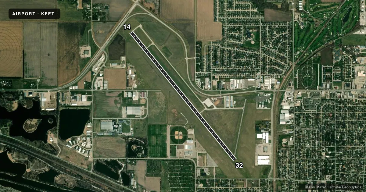
Airport sketch
Runways drawn to scale from FAA survey coordinates, rendered over satellite imagery. Not for navigation.
Approaches & charts
Services on the field
Fuel grades, oxygen, maintenance, ramp storage and lighting — as declared to the FAA by the airport operator.
Fuel & services
- Fuel
- 100LLA
- Oxygen (bottled)
- High pressure
- Oxygen (bulk)
- Low pressure
- Airframe repair
- Major
- Power plant repair
- Major
- Other services
- INSTR,RNTL
Ramp & ground
- Transient storage
- Tie-down
- Landing fee
- No fee published
- Customs
- Not available
- Lighting schedule
- SEE RMK
- Beacon schedule
- SS-SR
- Beacon
- White / Green (civil land)(WG)
- Wind indicator
- Lighted
- Segmented circle
- Yes
Fuel & FBOs
Cheapest 100LL and Jet A on the field and nearby. Always confirm with the FBO before taxi.
Airport notes
Surface conditions, obstructions, local procedures, lighting outages and other notes published with each FAA cycle.
General notes
- (E81) TURN OFF ONLY.
- FOR CD CTC OMAHA APCH AT 402-682-4395.
- FORMER RWY 1/19 IN USE AS TWY ONLY.
Lighting notes
- ACTVT REIL RY 14 & PAPI RYS 14 & 32 - CTAF.
Approach & departure obstructions
- 32PAPI LGT OTS INDEF.
- 14APCH SLP 43:1 TO DTHR OVR +29 FT LIGHT POLE, 1272 FT DIST.
- 32APCH SLP 30:1 TO DTHR OVR +66 FT TREE, 2017 FT DIST 309 L & +51 FT TREE, 1521 FT DIST, 405 L.
Other notes
- EXISTED PRIOR TO 1959.
- 1FOR ATTENDANT AFT HRS CALL (402) 727-4665/(402) 719-9364 OR (402) 720-2863.
- MANAGERCARI HOFFART, AIRPORT MANAGER & DAN GILLIS, PUBLIC WORKS DIRECTOR
- OWNERJODY SANDERS, CITY ADMINISTRATOR
- 14/32RWY 14 PVMNT SOUTH OF DSP THR PCI RATED POOR FOR 2300 FT.
VFR map & nearby airports
VFR sectional. Tap any ICAO chip to open that airport.
Key facts · KFET
Answer card- ICAO
- KFET
- Name
- FREMONT MUNI
- Location
- FREMONT, NEBRASKA
- Elevation
- 1,204 ft MSL
- Traffic pattern altitude
- 2,204 ft MSL (1,000 AGL)
- Control tower
- Non-towered (use CTAF)
- Total runways
- 1
- Longest runway
- 14/32 · 6,353 ft
- Published ILS approaches
- 0
- Published frequencies
- 4
- Magnetic variation
- 3°
- Current flight rules
- VFR
- Current wind
- 080° at 11 kt
- Favored runway now
- RWY 14
Fremont Muni sits in Fremont, Nebraska. The field elevation is 1,204 ft MSL. It has one runway, 14/32, which is 6,353 ft long and paved concrete. There is no control tower. Pattern altitude is not published, so use the standard 1,000 ft AGL pattern unless local procedure or the current Chart Supplement says otherwise.
No ILS approaches are published here. Omaha Approach handles clearance delivery and approach control. CTAF and UNICOM are both 122.8. Fremont Aviation is the on-field FBO. It carries 100LL and Jet A Prist. If you need service after hours, the published remarks list local contact numbers for an attendant.
A few runway notes matter here. The former runway 1/19 is taxiway only. Runway 14 has a displaced threshold with a light pole on the approach path. The pavement south of that displaced threshold is rated poor for 2,300 ft. Runway 32 has trees on the approach path. The PAPI on 32 is out of service indefinitely. REILs are available on runway 14. PAPI is available on both 14 and 32 through CTAF activation. This is a non-towered field with a long runway, so brief your arrival early and verify the current Chart Supplement for any operational changes before you go.