METAR & TAF KBTA
Current METAR
Observed 12:35Z
KBTA 271235Z AUTO 18004KT 7SM CLR 27/22 A2977 RMK AO2 T02700221
- Wind
- 180° @ 4 kt
- Visibility
- 7 SM
- Temp / Dew
- 27°C / 22°C
- Altimeter
- 29.77 inHg
- Clouds
- CLR
- Density alt
- 3,260 ft
- Ceiling
- Unlimited
- Rules
- VFR
Airport info & contacts
Manager on record, flight service, ARTCC, attendance schedule and pattern altitude — published by the FAA and refreshed every 28 days.
Location
- From city
- 7 NM S
- VFR sectional
- OMAHA
- ARTCC
- ZMP · MINNEAPOLIS
- NOTAM facility
- BTA (NOTAM-D)
Airport manager
- Name
- PHIL GREEN
- Phone
- 402-426-6693
- Address
- 218 SOUTH 16TH ST, BLAIR NE 68008-2000
Flight service · Hours
- FSS OLU
- COLUMBUS1-800-WX-BRIEF
- Attendance
- ON CALL
Frequencies
Tap any row to copy the frequency to your clipboard.
Runways & pattern
Full pagePattern entry · RWY 13
LEFT TRAFFICRunway end performance
| End | TORA | TODA | ASDA | LDA | VGSI | Approach lights | Obstruction |
|---|---|---|---|---|---|---|---|
| 13 | — | — | — | — | PAPI 2-box left(3°) | — | — |
| 31 | — | — | — | — | PAPI 2-box left(3°) | — | 53', pole, 1928' from thr, 407' R of cntrln, slope 32 |
Declared distances in feet. TORA = takeoff run available, TODA = takeoff distance, ASDA = accelerate-stop, LDA = landing distance.
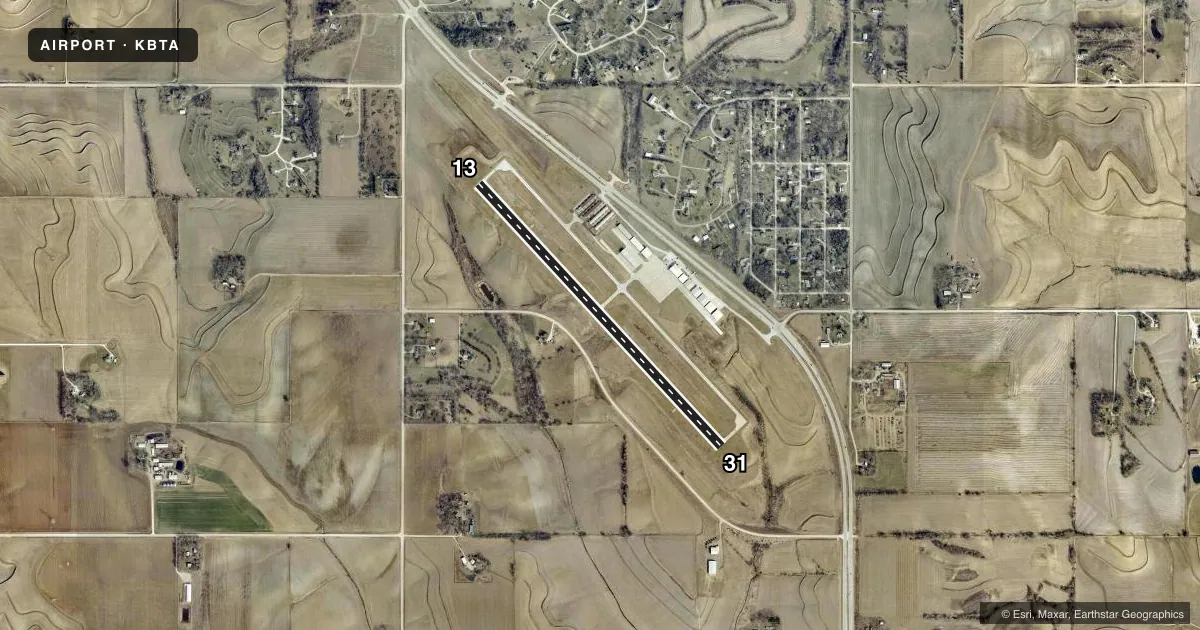
Airport sketch
Runways drawn to scale from FAA survey coordinates, rendered over satellite imagery. Not for navigation.
Approaches & charts
Services on the field
Fuel grades, oxygen, maintenance, ramp storage and lighting — as declared to the FAA by the airport operator.
Fuel & services
- Fuel
- 100LLA
- Oxygen (bottled)
- Not available
- Oxygen (bulk)
- Not available
- Airframe repair
- Not available
- Power plant repair
- Not available
Ramp & ground
- Transient storage
- Tie-down
- Landing fee
- No fee published
- Customs
- Not available
- Lighting schedule
- SEE RMK
- Beacon schedule
- SS-SR
- Beacon
- White / Green (civil land)(WG)
- Wind indicator
- Yes
- Segmented circle
- No
Fuel & FBOs
Cheapest 100LL and Jet A on the field and nearby. Always confirm with the FBO before taxi.
Airport notes
Surface conditions, obstructions, local procedures, lighting outages and other notes published with each FAA cycle.
General notes
- GLIDER ACTIVITY ON & INVOF ARPT.
- FOR NOISE ABATEMENT PROCEDURES CONTACT AMGR ON 402-426-4191.
- FOR CD CTC OMAHA APCH AT 402-682-4395.
Lighting notes
- ACTVT MIRL RY 13/31; PAPI RYS 13 & 31, AND REIL RY 31-CTAF.
Fuel notes
- 100LL24 HR SELF SVC FUEL AVBL WITH CREDIT CARD.
Other notes
- ESTABLISHED PRIOR TO 1959.
- SURVEYED
- 1FOR SERVICE CALL 402-533-2247.
- MANAGERCITY ADMINISTRATOR
VFR map & nearby airports
VFR sectional. Tap any ICAO chip to open that airport.
Key facts · KBTA
Answer card- ICAO
- KBTA
- Name
- BLAIR EXEC
- Location
- BLAIR, NEBRASKA
- Elevation
- 1,317.6 ft MSL
- Traffic pattern altitude
- 2,317.6 ft MSL (1,000 AGL)
- Control tower
- Non-towered (use CTAF)
- Total runways
- 1
- Longest runway
- 13/31 · 4,201 ft
- Published ILS approaches
- 0
- Published frequencies
- 4
- Magnetic variation
- 3°
- Current flight rules
- VFR
- Current wind
- 180° at 4 kt
- Favored runway now
- RWY 13
Blair Exec Airport sits in Blair, Nebraska. The field elevation is 1,317.6 ft MSL. It has one runway, 13/31, which is 4,201 ft long. There is no control tower. Pattern altitude is not published, so use the standard 1,000 ft AGL for light piston operations unless the current Chart Supplement says otherwise.
No ILS approaches are published here. Runway 13/31 has medium intensity lighting. PAPI is installed on both runway ends. Runway end identifier lights are installed on runway 31 and operate on CTAF. Glider activity occurs on and near the airport, so keep a sharp scan in the pattern and on departure.
SkyWerx Aviation is on the field. It carries 100LL and Jet A. Twenty-four hour self-serve 100LL is available with a credit card. For service, call the FBO at (402) 533-2247. For noise abatement procedures, contact the airport manager at 402-426-4191. Omaha Approach handles clearance delivery, so plan ahead if you need IFR services. The airport has been surveyed. The field was established before 1959, so expect a mature airport layout rather than a simple grass strip.