METAR & TAF KTQE
Current METAR
Observed 19:54Z
KTQE 271954Z AUTO 06006KT 10SM CLR 37/27 A2978 RMK AO2 SLP066 T03670267
- Wind
- 060° @ 6 kt
- Visibility
- 10 SM
- Temp / Dew
- 37°C / 27°C
- Altimeter
- 29.78 inHg
- Clouds
- CLR
- Density alt
- 4,087 ft
- Ceiling
- Unlimited
- Rules
- VFR
Airport info & contacts
Manager on record, flight service, ARTCC, attendance schedule and pattern altitude — published by the FAA and refreshed every 28 days.
Location
- From city
- 2 NM SE
- VFR sectional
- OMAHA
- ARTCC
- ZMP · MINNEAPOLIS
- NOTAM facility
- TQE (NOTAM-D)
Airport manager
- Name
- DOUG POLLOCK
- Phone
- 402-374-1700
- Address
- P.O. BOX 4, TEKAMAH NE 68061
Flight service · Hours
- FSS OLU
- COLUMBUS1-800-WX-BRIEF
- Attendance
- MON-FRI · 0800-1700
Frequencies
Tap any row to copy the frequency to your clipboard.
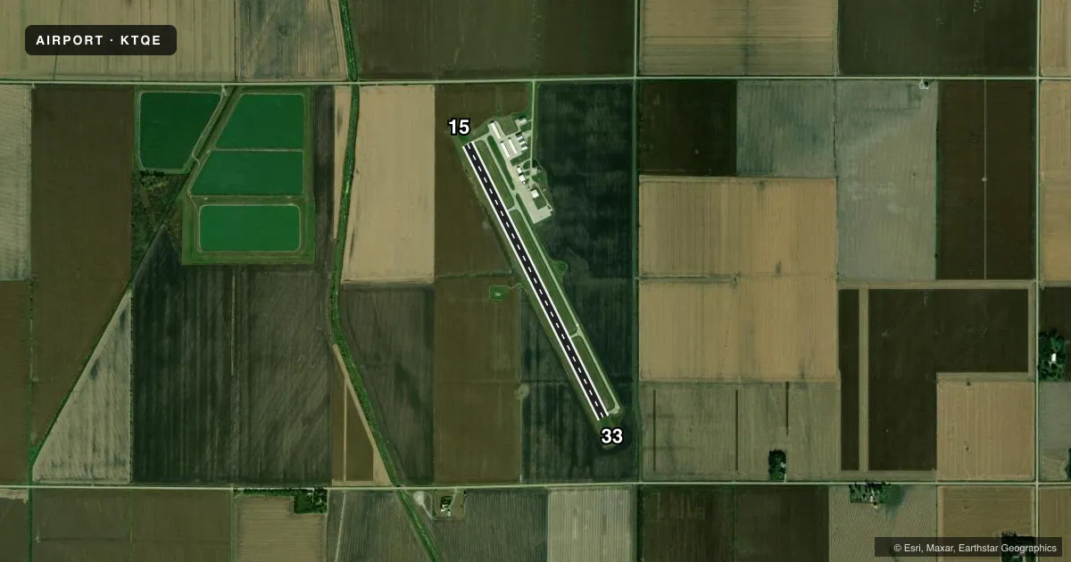
Runways & pattern
Full pagePattern entry · RWY 33
LEFT TRAFFICRunway end performance
| End | TORA | TODA | ASDA | LDA | VGSI | Approach lights | Obstruction |
|---|---|---|---|---|---|---|---|
| 33 | — | — | — | — | — | — | 15', road, 500' from thr, 295' R of cntrln, slope 20 |
Declared distances in feet. TORA = takeoff run available, TODA = takeoff distance, ASDA = accelerate-stop, LDA = landing distance.
Airport sketch
Runways drawn to scale from FAA survey coordinates, rendered over satellite imagery. Not for navigation.
Approaches & charts
Services on the field
Fuel grades, oxygen, maintenance, ramp storage and lighting — as declared to the FAA by the airport operator.
Fuel & services
- Fuel
- 100LL
- Oxygen (bottled)
- Not available
- Oxygen (bulk)
- Not available
- Airframe repair
- Major
- Power plant repair
- Major
- Other services
- AGRI
Ramp & ground
- Transient storage
- Tie-down
- Hangar
- Landing fee
- No fee published
- Customs
- Not available
- Lighting schedule
- SEE RMK
- Beacon schedule
- SS-SR
- Beacon
- White / Green (civil land)(WG)
- Wind indicator
- Lighted
- Segmented circle
- Yes
Fuel & FBOs
Cheapest 100LL and Jet A on the field and nearby. Always confirm with the FBO before taxi.
Airport notes
Surface conditions, obstructions, local procedures, lighting outages and other notes published with each FAA cycle.
General notes
- FOR SVC AFT HRS CALL 402-457-4373/402-870-0058.
- FOR CD CTC OMAHA APCH AT 402-682-4395.
Lighting notes
- ACTVT RY 33 REIL - CTAF.
Fuel notes
- 100LL100LL FUEL AVBL 24 HRS. SELF SVC.
Approach & departure obstructions
- 33RWY 33 SML TREES 81 FT FM RWY END 194 FT RIGHT.
- 15UNLIGHTED CENTER PIVOT IRRIGATOR ROTATES THROUGH RWY 15 APPROACH DURING IRRIGATION SEASON
Other notes
- J&D AIRCRAFT SERVICE 402-374-1700.
- J&D AIRCRAFT SERVICE 402-374-1700.
- 1FOR ATTENDANT CALL 402-374-1700.
- OWNERCHMN ARPT AUTH, CHARLES GOLL.
VFR map & nearby airports
VFR sectional. Tap any ICAO chip to open that airport.
Key facts · KTQE
Answer card- ICAO
- KTQE
- Name
- TEKAMAH MUNI
- Location
- TEKAMAH, NEBRASKA
- Elevation
- 1,026.8 ft MSL
- Traffic pattern altitude
- 2,026.8 ft MSL (1,000 AGL)
- Control tower
- Non-towered (use CTAF)
- Total runways
- 1
- Longest runway
- 15/33 · 4,000 ft
- Published ILS approaches
- 0
- Published frequencies
- 4
- Magnetic variation
- 3°
- Current flight rules
- VFR
- Current wind
- 060° at 6 kt
- Favored runway now
- RWY 33
Tekamah Muni sits in Tekamah, Nebraska. The field elevation is 1,026.8 ft MSL. It has one runway. Runway 15/33 is 4,000 ft long with a concrete surface. There is no control tower. Omaha Approach handles clearance delivery and departure control. No ILS approaches are published here.
Pattern altitude is not published. Use the standard 1,000 ft AGL pattern for light piston traffic unless the current Chart Supplement says otherwise. The airport carries CTAF and UNICOM on 123.0. The on-field FBO is Tekamah Municipal Airport. It carries 100LL and Jet A. The published remarks also note 24-hour self-serve 100LL. J&D Aircraft Service is listed with the same phone number for attendant calls.
A few field-specific items matter here. An unlighted center pivot irrigator crosses the Runway 15 approach during irrigation season. Runway 33 has small trees near the departure end. Runway 33 REIL lighting is activated by CTAF. If you are planning a first stop here, brief the irrigator on 15. Brief the trees off 33. Brief the lack of published ILS guidance. Check the current FAA Chart Supplement for any updated noise or operational notes before you go.