METAR & TAF 0C4
0C4 does not publish a METAR.
Showing the nearest reporting station: KLCG (WAYNE MUNI/STAN MORRIS FLD) · 13.7 NM away. Conditions at 0C4 may differ.
METAR · KLCG
Observed 18:55Z
KLCG 271855Z AUTO 03013KT 10SM CLR 34/26 A2983 RMK AO2 T03420262
- Wind
- 030° @ 13 kt
- Visibility
- 10 SM
- Temp / Dew
- 34°C / 26°C
- Altimeter
- 29.83 inHg
- Clouds
- CLR
- Density alt
- 4,060 ft
- Ceiling
- Unlimited
- Rules
- VFR
Airport info & contacts
Manager on record, flight service, ARTCC, attendance schedule and pattern altitude — published by the FAA and refreshed every 28 days.
Location
- From city
- 1 NM W
- VFR sectional
- OMAHA
- ARTCC
- ZMP · MINNEAPOLIS
- NOTAM facility
- OLU (NOTAM-D)
Airport manager
- Name
- JOHN MILLER
- Phone
- (816) 210-2081
- Address
- P.O. BOX 194, PENDER NE 68047-0194
Flight service · Hours
- FSS OLU
- COLUMBUS1-800-WX-BRIEF
- Attendance
- Unattended
Frequencies
Tap any row to copy the frequency to your clipboard.
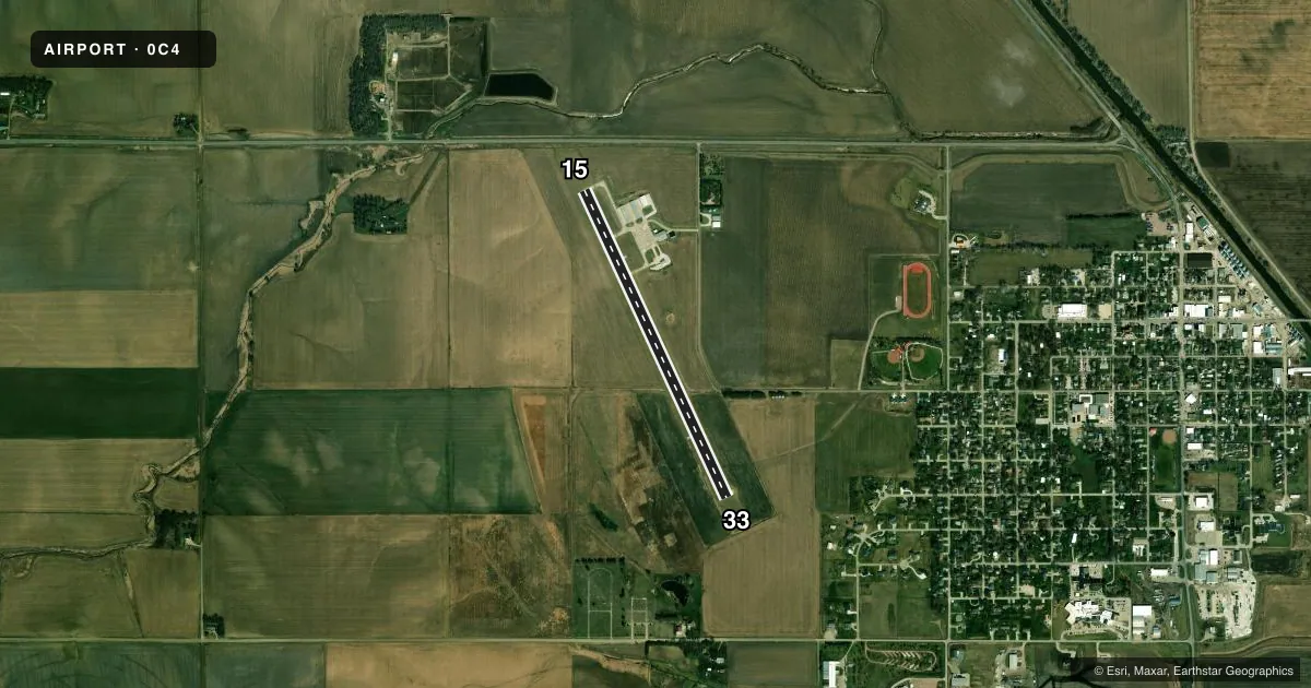
Runways & pattern
Full pagePattern entry · RWY 33
LEFT TRAFFICRunway end performance
| End | TORA | TODA | ASDA | LDA | VGSI | Approach lights | Obstruction |
|---|---|---|---|---|---|---|---|
| 15 | — | — | — | — | PAPI 2-box left(3°) | — | 15', road, 441' from thr, 296' R of cntrln, slope 16 |
| 33 | — | — | — | — | PAPI 2-box left(3°) | — | — |
Declared distances in feet. TORA = takeoff run available, TODA = takeoff distance, ASDA = accelerate-stop, LDA = landing distance.
Airport sketch
Runways drawn to scale from FAA survey coordinates, rendered over satellite imagery. Not for navigation.
Approaches & charts
Services on the field
Fuel grades, oxygen, maintenance, ramp storage and lighting — as declared to the FAA by the airport operator.
Fuel & services
- Fuel
- 100LL
- Oxygen (bottled)
- Not available
- Oxygen (bulk)
- Not available
- Airframe repair
- Not available
- Power plant repair
- Not available
- Other services
- AGRI
Ramp & ground
- Transient storage
- Tie-down
- Landing fee
- No fee published
- Customs
- Not available
- Lighting schedule
- SEE RMK
- Beacon schedule
- SS-SR
- Beacon
- White / Green (civil land)(WG)
- Wind indicator
- Lighted
- Segmented circle
- Yes
Fuel & FBOs
Cheapest 100LL and Jet A on the field and nearby. Always confirm with the FBO before taxi.
Airport notes
Surface conditions, obstructions, local procedures, lighting outages and other notes published with each FAA cycle.
General notes
- COURTESY CAR AVBL WITH 24 HR NOTICE.
- FOR CD CTC SIOUX CITY APCH AT 712-293-2482. WHEN SIOUX CITY APCH CLSD, FOR CD CTC MINNEAPOLIS ARTCC AT 651-463-5588.
Lighting notes
- ACTVT MIRL RY 15/33; PAPI RYS 15 & 33 AFT 2230 - CTAF
Fuel notes
- 100LL24 HOUR CREDIT CARD OR CALL 816-210-2081
Approach & departure obstructions
- 33RWY 33 CLNC SLOPE 41:1 DUE TO TREE 1918 FT FM & 41 FT ABV RWY END; 292 R.
Other notes
- OWNERCHAIRMAN MARK KINNING
- MANAGERCELL PHONE 816-210-2081
VFR map & nearby airports
VFR sectional. Tap any ICAO chip to open that airport.
Key facts · 0C4
Answer card- ICAO
- 0C4
- Name
- PENDER MUNI
- Location
- PENDER, NEBRASKA
- Elevation
- 1,345.4 ft MSL
- Traffic pattern altitude
- 2,345.4 ft MSL (1,000 AGL)
- Control tower
- Non-towered (use CTAF)
- Total runways
- 1
- Longest runway
- 15/33 · 3,600 ft
- Published ILS approaches
- 0
- Published frequencies
- 3
- Magnetic variation
- 4°
- Current flight rules
- VFR
- Current wind
- 030° at 13 kt
- Favored runway now
- RWY 33
Pender Muni sits in Pender, Nebraska. Field elevation is 1,345.4 ft MSL. The airport has one runway. Runway 15/33 is 3,600 ft of concrete and is the longest runway on the field. There is no control tower. The pattern altitude is not published, so use the standard 1,000 ft AGL for light piston traffic unless the current Chart Supplement says otherwise.
No ILS approaches are published here. The field uses CTAF 122.9. Sioux City Approach handles approach and departure work on 124.6 and 307.0. For clearance delivery, contact Sioux City Approach. If that office is closed, use Minneapolis ARTCC instead. Pender Municipal Airport is the on-field FBO. It carries 100LL. 100LL is available 24 hours by credit card or by calling the manager. A courtesy car is available with 24 hours notice.
Runway 15/33 has medium intensity lights. PAPI is available on both ends after 2230 on CTAF. Runway 33 has a tree-related obstruction note. The published slope is reduced by a tree off the departure end. That is worth checking before a short-field or high-weight departure. The field is in open country, so watch the wind. Crosswinds can matter on a 3,600 ft runway, especially with no tower and no published ILS.