METAR & TAF KOFK
Current METAR
Observed 15:56Z
KOFK 271556Z AUTO 03016KT 10SM CLR 35/25 A2981 RMK AO2 SLP074 T03500250
- Wind
- 030° @ 16 kt
- Visibility
- 10 SM
- Temp / Dew
- 35°C / 25°C
- Altimeter
- 29.81 inHg
- Clouds
- CLR
- Density alt
- 4,486 ft
- Ceiling
- Unlimited
- Rules
- VFR
Airport info & contacts
Manager on record, flight service, ARTCC, attendance schedule and pattern altitude — published by the FAA and refreshed every 28 days.
Location
- From city
- 3 NM SW
- VFR sectional
- OMAHA
- ARTCC
- ZMP · MINNEAPOLIS
- NOTAM facility
- OFK (NOTAM-D)
Airport manager
- Name
- MR JUSTIN MARTIN
- Phone
- 402-841-5130
- Address
- P.O. BOX 1343, NORFOLK NE 68702-1343
Flight service · Hours
- FSS OLU
- COLUMBUS1-800-WX-BRIEF
- Attendance
- M-F · 0700-1900
- SAT · 0700-1700
- SUN · 1000-1700
Frequencies
Tap any row to copy the frequency to your clipboard.
Runways & pattern
Full pagePattern entry · RWY 02
LEFT TRAFFIC| Runway | Heading (°M) | Length | Surface | Traffic |
|---|---|---|---|---|
| 14/32 | 137° / 317° | 5,806 ft | ASPH | Standard L |
| 02/20Favored | 14° / 194° | 5,801 ft | ASPH | Standard L |
Runway end performance
| End | TORA | TODA | ASDA | LDA | VGSI | Approach lights | Obstruction |
|---|---|---|---|---|---|---|---|
| 14 | 5,443' | 5,800' | 5,443' | 5,160' | PAPI 4-box left(3°) | — | 28', rr, 952' from thr, 364' R of cntrln, slope 26 |
| 32 | 5,517' | 5,800' | 5,517' | 5,160' | PAPI 4-box left(3.5°) | — | 59', tree, 1535' from thr, 105' R of cntrln, slope 22 |
| 02 | — | — | — | — | PAPI 4-box left(3°) | MALSR | 27', fence, 1182' from thr, 647' R of cntrln, slope 36 |
| 20 | — | — | — | — | PAPI 4-box left(3°) | — | 73', tree, 1391' from thr, 597' R of cntrln, slope 16 |
Declared distances in feet. TORA = takeoff run available, TODA = takeoff distance, ASDA = accelerate-stop, LDA = landing distance.
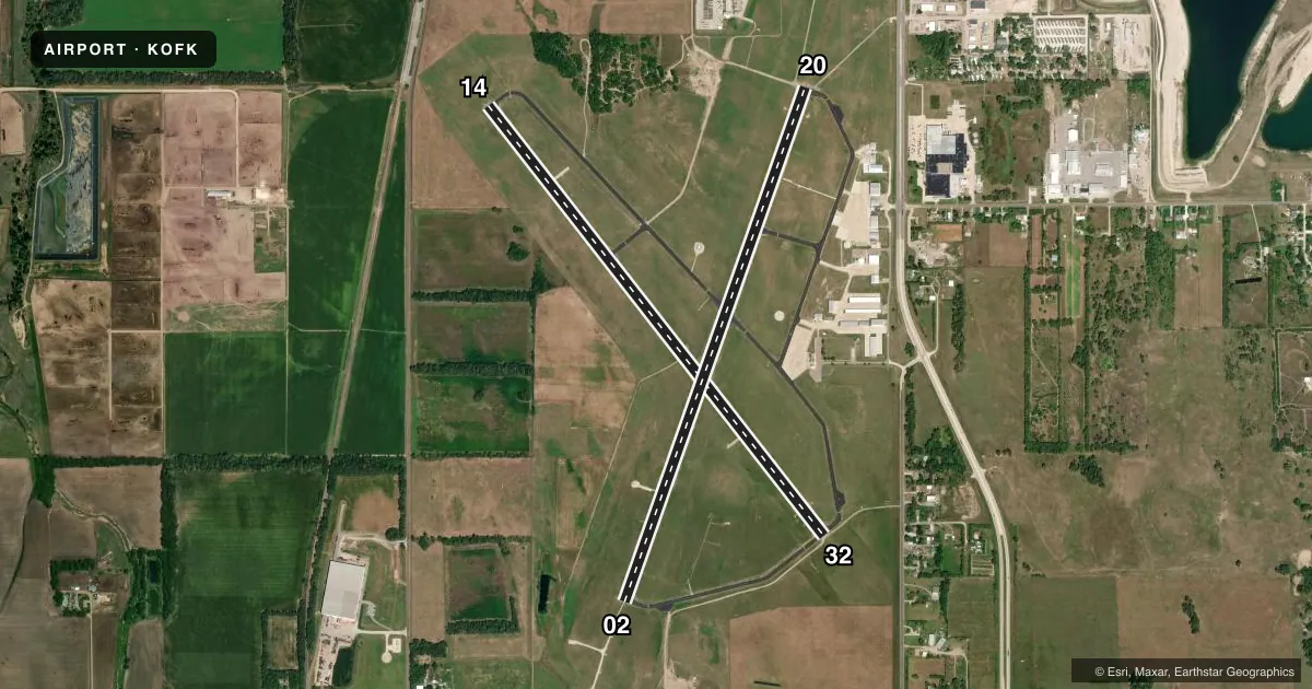
Airport sketch
Runways drawn to scale from FAA survey coordinates, rendered over satellite imagery. Not for navigation.
Approaches & charts
ILS · 1
Services on the field
Fuel grades, oxygen, maintenance, ramp storage and lighting — as declared to the FAA by the airport operator.
Fuel & services
- Fuel
- 100LLA+
- Oxygen (bottled)
- HIGH/LOW
- Oxygen (bulk)
- Not available
- Airframe repair
- Minor
- Power plant repair
- Minor
- Other services
- AGRI,INSTR,RNTL
Ramp & ground
- Transient storage
- Tie-down
- Hangar
- Landing fee
- No fee published
- Customs
- Not available
- Lighting schedule
- SEE RMK
- Beacon schedule
- SS-SR
- Beacon
- White / Green (civil land)(WG)
- Wind indicator
- Lighted
- Segmented circle
- Yes
Fuel & FBOs
Cheapest 100LL and Jet A on the field and nearby. Always confirm with the FBO before taxi.
Airport notes
Surface conditions, obstructions, local procedures, lighting outages and other notes published with each FAA cycle.
General notes
- RWY 20 DSGND AS CALM WIND RWY. ALL RWYS HAVE L HAND TFC ONLY.
- FOR CD IF UNA TO CTC ON FSS FREQ, CTC MINNEAPOLIS ARTCC AT 651-463-5588.
Lighting notes
- ACTVT MALSR RWY 02; REIL RWY 20; PAPI RWYS 02, 20, 14, & 32; HIRL RWY 02/20; MIRL RWY 14/32 - CTAF.
Fuel notes
- 100LLSELF SVC FUEL AVBL H24 100LL ONLY.
Approach & departure obstructions
- 14CLNC SLP TO DTHR 42:1 DUE TO RR 1185 FT FM DTHR 428 FT R.
- 32CLNC SLP TO DTHR 32:1 DUE TO 59 FT TREE 1895 FT FM DTHR 105 FT R.
Other notes
- ENGINE OVERHAULS NOT PERFORMED IN-HOUSE.
- CALL AHEAD FOR HNGR AVBL 402-841-5130.
- 1FOR SVC AFT HRS CALL 402-841-5130
VFR map & nearby airports
VFR sectional. Tap any ICAO chip to open that airport.
Key facts · KOFK
Answer card- ICAO
- KOFK
- Name
- NORFOLK RGNL/KARL STEFAN MEML FLD
- Location
- NORFOLK, NEBRASKA
- Elevation
- 1,572.6 ft MSL
- Traffic pattern altitude
- 2,572.6 ft MSL (1,000 AGL)
- Control tower
- Non-towered (use CTAF)
- Total runways
- 2
- Longest runway
- 14/32 · 5,806 ft
- Published ILS approaches
- 1
- Published frequencies
- 2
- Magnetic variation
- 5°
- Current flight rules
- VFR
- Current wind
- 030° at 16 kt
- Favored runway now
- RWY 02
Norfolk Rgnl/Karl Stefan Meml Fld sits in Norfolk, Nebraska. The field elevation is 1,572.6 ft MSL. It has two asphalt runways. The longest is 5,806 ft on runway 14/32. There is no control tower. CTAF and UNICOM are both 122.7.
Runway 02 has the published ILS approach. The airport also has PAPI on all runway ends. The pattern altitude is not published, so use standard 1,000 ft AGL for light piston aircraft unless the current FAA Chart Supplement says otherwise. That puts the light-aircraft pattern at 2,572.6 ft MSL.
Norfolk Airport Services is on the field. It carries 100LL and Jet A. Self-serve 100LL is available 24 hours a day. For after-hours service or hangar questions, the published contact number is 402-841-5130. The airport remarks also note that runway 20 is the calm wind runway. All runways use left-hand traffic only.
A first-time pilot should pay attention to the displaced threshold clearance notes on runway 14 and runway 32. The published remarks also mention a railroad near the runway 14 threshold area and a tree near the runway 32 threshold area. If you need clearance delivery and cannot reach flight service, the Chart Supplement says to contact Minneapolis ARTCC. Check the current FAA Chart Supplement before departure for any updates to procedures or remarks.