METAR & TAF KBVN
Current METAR
Observed 18:55Z
KBVN 261855Z AUTO 14008KT 10SM CLR 35/25 A2984 RMK AO2 T03500252
- Wind
- 140° @ 8 kt
- Visibility
- 10 SM
- Temp / Dew
- 35°C / 25°C
- Altimeter
- 29.84 inHg
- Clouds
- CLR
- Density alt
- 4,739 ft
- Ceiling
- Unlimited
- Rules
- VFR
Airport info & contacts
Manager on record, flight service, ARTCC, attendance schedule and pattern altitude — published by the FAA and refreshed every 28 days.
Location
- From city
- 3 NM NW
- VFR sectional
- OMAHA
- ARTCC
- ZMP · MINNEAPOLIS
- NOTAM facility
- BVN (NOTAM-D)
Airport manager
- Name
- BOB SANDMAN
- Phone
- 402-741-1290
- Address
- P.O. BOX 3, ALBION NE 68620-0003
Flight service · Hours
- FSS OLU
- COLUMBUS1-800-WX-BRIEF
- Attendance
- Unattended
Frequencies
Tap any row to copy the frequency to your clipboard.
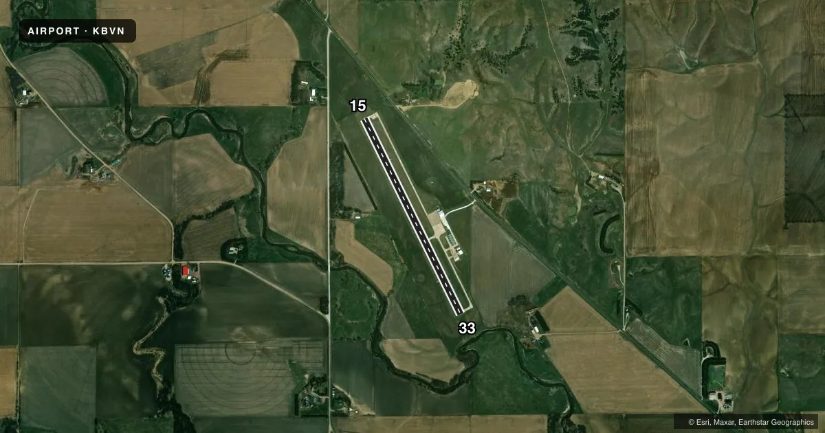
Runways & pattern
Full pagePattern entry · RWY 15
LEFT TRAFFICRunway end performance
| End | TORA | TODA | ASDA | LDA | VGSI | Approach lights | Obstruction |
|---|---|---|---|---|---|---|---|
| 15 | — | — | — | — | PAPI 2-box left(3°) | — | 66', tree, 1022' from thr, 356' R of cntrln, slope 12 |
| 33 | — | — | — | — | PAPI 2-box left(3°) | — | 30', tree, 766' from thr, 252' R of cntrln, slope 18 |
Declared distances in feet. TORA = takeoff run available, TODA = takeoff distance, ASDA = accelerate-stop, LDA = landing distance.
Airport sketch
Runways drawn to scale from FAA survey coordinates, rendered over satellite imagery. Not for navigation.
Approaches & charts
Services on the field
Fuel grades, oxygen, maintenance, ramp storage and lighting — as declared to the FAA by the airport operator.
Fuel & services
- Fuel
- 100LL
- Oxygen (bottled)
- Not available
- Oxygen (bulk)
- Not available
- Airframe repair
- Not available
- Power plant repair
- Not available
- Other services
- AGRI
Ramp & ground
- Transient storage
- Tie-down
- Hangar
- Landing fee
- No fee published
- Customs
- Not available
- Lighting schedule
- SEE RMK
- Beacon schedule
- SS-SR
- Beacon
- White / Green (civil land)(WG)
- Wind indicator
- Lighted
- Segmented circle
- Yes
Fuel & FBOs
Cheapest 100LL and Jet A on the field and nearby. Always confirm with the FBO before taxi.
Airport notes
Surface conditions, obstructions, local procedures, lighting outages and other notes published with each FAA cycle.
General notes
- FOR CD CTC MINNEAPOLIS ARTCC AT 651-463-5588.
Lighting notes
- ACTVT MIRL RWY 15/33 - CTAF.
Fuel notes
- 100LLSELF SVC FUEL AVBL H24 VIA CREDIT CARD.
Approach & departure obstructions
- 15RWY 15 APCH; TREE AT 42 FT ABV RWY; 882 FT FM RWY END, 310 FT R; CREATES A 16:1.
VFR map & nearby airports
VFR sectional. Tap any ICAO chip to open that airport.
Key facts · KBVN
Answer card- ICAO
- KBVN
- Name
- ALBION MUNI
- Location
- ALBION, NEBRASKA
- Elevation
- 1,806.4 ft MSL
- Traffic pattern altitude
- 2,806.4 ft MSL (1,000 AGL)
- Control tower
- Non-towered (use CTAF)
- Total runways
- 1
- Longest runway
- 15/33 · 3,700 ft
- Published ILS approaches
- 0
- Published frequencies
- 1
- Magnetic variation
- 6°
- Current flight rules
- VFR
- Current wind
- 140° at 8 kt
- Favored runway now
- RWY 15
Albion Muni is in Albion, Nebraska. The field elevation is 1,806.4 ft MSL. It has one runway, 15/33, which is 3,700 ft long. There is no control tower. No ILS approaches are published here. Pattern altitude is not published, so use the standard 1,000 ft AGL for light piston traffic unless the current Chart Supplement says otherwise.
The on-field FBO is Albion Municipal Airport. It carries AVGAS 100LL. Self-serve fuel is available 24 hours by credit card. Runway 15/33 has medium intensity lights that are activated by CTAF. Runway 15 also has a published tree obstruction on short final. It sits 42 ft above runway level, 882 ft from the runway end, 310 ft right of centerline. That is worth checking before you plan a straight-in or a low approach.
This is a non-towered field, so listen early on CTAF 122.9 and build a solid traffic picture. For clearance delivery, contact Minneapolis ARTCC at the published phone number. The runway is concrete. With one runway and no published ILS, weather and wind will drive the runway choice. If you are new to the airport, brief the obstacle on 15, confirm lighting activation and verify current procedures in the FAA Chart Supplement before you go.