METAR & TAF KODX
Current METAR
Observed 15:53Z
KODX 271553Z AUTO 04014G19KT 10SM CLR 33/28 A2984 RMK AO2 SLP086 T03330283 $
- Wind
- 040° @ 14G19 kt
- Visibility
- 10 SM
- Temp / Dew
- 33°C / 28°C
- Altimeter
- 29.84 inHg
- Clouds
- CLR
- Density alt
- 4,826 ft
- Ceiling
- Unlimited
- Rules
- VFR
Airport info & contacts
Manager on record, flight service, ARTCC, attendance schedule and pattern altitude — published by the FAA and refreshed every 28 days.
Location
- From city
- 2 NM NW
- VFR sectional
- OMAHA
- ARTCC
- ZMP · MINNEAPOLIS
- NOTAM facility
- ODX (NOTAM-D)
Airport manager
- Name
- DAVE WILLIAMS
- Phone
- 308-750-5126
- Address
- 81385 HIGHWAY 11, ORD NE 68862-5354
Flight service · Hours
- FSS OLU
- COLUMBUS1-800-WX-BRIEF
- Attendance
- 0800-1700
Frequencies
Tap any row to copy the frequency to your clipboard.
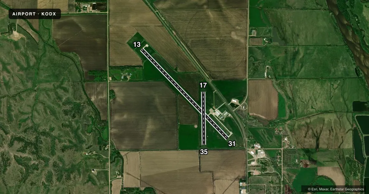
Runways & pattern
Full pagePattern entry · RWY 35
LEFT TRAFFIC| Runway | Heading (°M) | Length | Surface | Traffic |
|---|---|---|---|---|
| 13/31 | 131° / 311° | 4,721 ft | CONC | Standard L |
| 17/35Favored | 174° / 354° | 2,012 ft | TURF | Standard L |
Runway end performance
| End | TORA | TODA | ASDA | LDA | VGSI | Approach lights | Obstruction |
|---|---|---|---|---|---|---|---|
| 13 | — | — | — | — | PAPI 2-box left(3°) | — | — |
| 31 | — | — | — | — | PAPI 2-box left(3°) | — | 34', pole, 797' from thr, 308' R of cntrln, slope 17 |
Declared distances in feet. TORA = takeoff run available, TODA = takeoff distance, ASDA = accelerate-stop, LDA = landing distance.
Airport sketch
Runways drawn to scale from FAA survey coordinates, rendered over satellite imagery. Not for navigation.
Approaches & charts
Services on the field
Fuel grades, oxygen, maintenance, ramp storage and lighting — as declared to the FAA by the airport operator.
Fuel & services
- Fuel
- 100LL
- Oxygen (bottled)
- Not available
- Oxygen (bulk)
- Not available
- Other services
- AGRI,INSTR
Ramp & ground
- Transient storage
- Tie-down
- Hangar
- Landing fee
- No fee published
- Customs
- Not available
- Lighting schedule
- SEE RMK
- Beacon schedule
- SS-SR
- Beacon
- White / Green (civil land)(WG)
- Wind indicator
- Lighted
- Segmented circle
- Yes
Fuel & FBOs
Cheapest 100LL and Jet A on the field and nearby. Always confirm with the FBO before taxi.
Airport notes
Surface conditions, obstructions, local procedures, lighting outages and other notes published with each FAA cycle.
General notes
- FOR CD CTC MINNEAPOLIS ARTCC AT 651-463-5588.
Lighting notes
- ACTVT REIL RWY 13 & 31; PAPI RWY 13 & 31; MIRL RWY 13/31 - CTAF.
Fuel notes
- 100LLSELF SVC FUEL AVBL H24 HR VIA CREDIT CARD.
Approach & departure obstructions
- 134 FT FENCE 237 FT RIGHT.
- 13RWY 31 CLNC SLP 29:1 FM DSPLCD THR
- 13CLNC SLP 29:1 FM DTHR.
- 35DURING CROP SEASON CORN AT 120' MAKES APCH RATIO 15-1.
Other notes
- CALL AHD FOR TRANSIENT HNGR AVBL AMGR.
- 1FOR SVCS AFTER HRS AMGR.
- OWNERDON VANCURA, CHMN ARPT AUTH.
VFR map & nearby airports
VFR sectional. Tap any ICAO chip to open that airport.
Key facts · KODX
Answer card- ICAO
- KODX
- Name
- EVELYN SHARP FLD
- Location
- ORD, NEBRASKA
- Elevation
- 2,070 ft MSL
- Traffic pattern altitude
- 3,070 ft MSL (1,000 AGL)
- Control tower
- Non-towered (use CTAF)
- Total runways
- 2
- Longest runway
- 13/31 · 4,721 ft
- Published ILS approaches
- 0
- Published frequencies
- 2
- Magnetic variation
- 5°
- Current flight rules
- VFR
- Current wind
- 040° at 14 kt
- Favored runway now
- RWY 35
Evelyn Sharp Fld sits near Ord, Nebraska. The field elevation is 2,070 ft MSL. It has two runways. The longest is runway 13/31 at 4,721 ft. There is no control tower, so use CTAF 122.8 for the pattern and ground coordination. No ILS approaches are published here. Pattern altitude is not published, so a first-time pilot should verify the current traffic pattern in the FAA Chart Supplement before arrival.
Runway 13/31 is the main paved runway. It has runway end identifier lights, PAPI and medium intensity runway lights. Runway 17/35 is turf at 2,012 ft. Published remarks note a 29:1 clearance slope off runway 13 and from the displaced threshold on runway 31. There is also a 4-foot fence 237 feet right of runway 13. During crop season, corn near runway 35 creates a tighter approach picture. That is worth checking before a low approach or short-field work.
Williams Flying Service is on the field. It carries 100LL. Self-serve 100LL is available 24 hours a day by credit card. For clearance delivery, contact Minneapolis ARTCC. For after-hours service, contact the airport manager. Call ahead for transient hangar space if you need it.