METAR & TAF 09K
09K does not publish a METAR.
Showing the nearest reporting station: KODX (EVELYN SHARP FLD) · 17.5 NM away. Conditions at 09K may differ.
METAR · KODX
Observed 15:53Z
KODX 271553Z AUTO 04014G19KT 10SM CLR 33/28 A2984 RMK AO2 SLP086 T03330283 $
- Wind
- 040° @ 14G19 kt
- Visibility
- 10 SM
- Temp / Dew
- 33°C / 28°C
- Altimeter
- 29.84 inHg
- Clouds
- CLR
- Density alt
- 5,127 ft
- Ceiling
- Unlimited
- Rules
- VFR
Airport info & contacts
Manager on record, flight service, ARTCC, attendance schedule and pattern altitude — published by the FAA and refreshed every 28 days.
Location
- From city
- 2 NM E
- VFR sectional
- OMAHA
- ARTCC
- ZDV · DENVER
- NOTAM facility
- OLU (NOTAM-D)
Airport manager
- Name
- BILL GRANT
- Phone
- 308-214-1062
- Address
- 200 S. 6TH ST., SARGENT NE 68874-0134
Flight service · Hours
- FSS OLU
- COLUMBUS1-800-WX-BRIEF
- Attendance
- Unattended
Frequencies
Tap any row to copy the frequency to your clipboard.
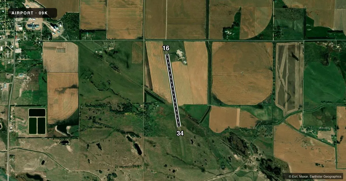
Runways & pattern
Full pagePattern entry · RWY 34
LEFT TRAFFICAirport sketch
Runways drawn to scale from FAA survey coordinates, rendered over satellite imagery. Not for navigation.
Approaches & charts
Services on the field
Fuel grades, oxygen, maintenance, ramp storage and lighting — as declared to the FAA by the airport operator.
Fuel & services
- Fuel
- Not available
- Oxygen (bottled)
- Not available
- Oxygen (bulk)
- Not available
- Other services
- AGRI
Ramp & ground
- Transient storage
- Tie-down
- Hangar
- Landing fee
- No fee published
- Customs
- Not available
- Lighting schedule
- SEE RMK
- Beacon schedule
- SS-SR
- Beacon
- White / Green (civil land)(WG)
- Wind indicator
- Yes
- Segmented circle
- No
Fuel & FBOs
Cheapest 100LL and Jet A on the field and nearby. Always confirm with the FBO before taxi.
Airport notes
Surface conditions, obstructions, local procedures, lighting outages and other notes published with each FAA cycle.
General notes
- DEER ON & INVOF ARPT.
- PILOT LOUNGE DOOR CODE: #1229
- FOR CD CTC DENVER ARTCC AT 303-651-4257.
Lighting notes
- ACTVT MIRL RWY 16/34 -CTAF.
Approach & departure obstructions
- 16CTLG OBSTN, ROAD 551 FT OUT FM RWY END, CLNC SLP 21:1.
Other notes
- EXISTED PRIOR TO 1959.
- CALL AHD TO RES HNGR SPACE 308-215-0437.
VFR map & nearby airports
VFR sectional. Tap any ICAO chip to open that airport.
Key facts · 09K
Answer card- ICAO
- 09K
- Name
- SARGENT MUNI
- Location
- SARGENT, NEBRASKA
- Elevation
- 2,313 ft MSL
- Traffic pattern altitude
- 3,313 ft MSL (1,000 AGL)
- Control tower
- Non-towered (use CTAF)
- Total runways
- 1
- Longest runway
- 16/34 · 3,000 ft
- Published ILS approaches
- 0
- Published frequencies
- 1
- Magnetic variation
- 8°
- Current flight rules
- VFR
- Current wind
- 040° at 14 kt
- Favored runway now
- RWY 34
Sargent Muni sits in Sargent, Nebraska. The field elevation is 2,313 ft MSL. It has one runway. Runway 16/34 is 3,000 ft asphalt, with magnetic headings of 171° and 351°. There is no control tower. CTAF is 122.9.
No ILS approaches are published here. Pattern altitude is not published, so use the current Chart Supplement and local traffic calls before you arrive. The airport is at higher prairie elevation, so expect a little more takeoff and climb performance planning than you would at a low field. Deer are reported on and near the airport. That matters on taxi, takeoff and landing roll.
The published remarks also note a road 551 ft off the runway 16 end. That is worth keeping in mind on the departure end. Medium intensity runway lights for 16/34 are pilot-activated on CTAF. The pilot lounge door code is 1229. For clearance delivery, contact Denver ARTCC at 303-651-4257. No on-field FBOs are listed, so verify services with the airport operator before you go. The airport existed before 1959. That tells you this is a long-established local field rather than a modern controlled facility.