METAR & TAF KCZD
KCZD does not publish a METAR.
Showing the nearest reporting station: KLXN (JIM KELLY FLD) · 11.4 NM away. Conditions at KCZD may differ.
METAR · KLXN
Observed 13:35Z
KLXN 271335Z AUTO 00000KT 10SM CLR 27/24 A2987 RMK AO2 T02690243
- Wind
- 000° @ 0 kt
- Visibility
- 10 SM
- Temp / Dew
- 27°C / 24°C
- Altimeter
- 29.87 inHg
- Clouds
- CLR
- Density alt
- 4,606 ft
- Ceiling
- Unlimited
- Rules
- VFR
Airport info & contacts
Manager on record, flight service, ARTCC, attendance schedule and pattern altitude — published by the FAA and refreshed every 28 days.
Location
- From city
- 1 NM NW
- VFR sectional
- OMAHA
- ARTCC
- ZDV · DENVER
- NOTAM facility
- OLU (NOTAM-D)
Airport manager
- Name
- ALLISON DONNER
- Phone
- 308-784-3868
- Address
- P.O. BOX 458, COZAD NE 69130-0458
Flight service · Hours
- FSS OLU
- COLUMBUS1-800-WX-BRIEF
- Attendance
- MON-FRI · 0800-1700
Frequencies
Tap any row to copy the frequency to your clipboard.
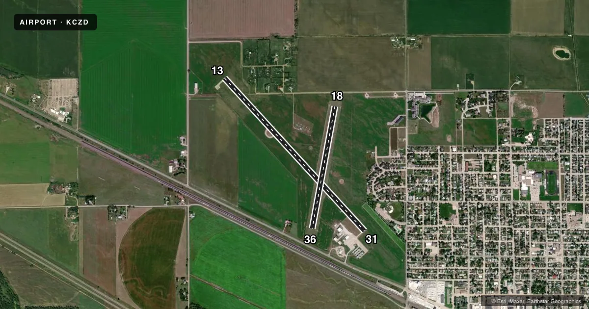
Runways & pattern
Full pagePattern entry · RWY 13
LEFT TRAFFIC| Runway | Heading (°M) | Length | Surface | Traffic |
|---|---|---|---|---|
| 13/31 | 130° / 310° | 5,000 ft | CONC | Standard L |
| 18/36 | 184° / 4° | 3,000 ft | TURF | Standard L |
Runway end performance
| End | TORA | TODA | ASDA | LDA | VGSI | Approach lights | Obstruction |
|---|---|---|---|---|---|---|---|
| 13 | — | — | — | — | PAPI 2-box left(3°) | — | — |
| 31 | — | — | — | — | PAPI 2-box left(3.75°) | — | 167', other, 3560' from thr, 330' R of cntrln, slope 20 |
| 18 | — | — | — | — | — | — | 15', road, 309' from thr, 156' R of cntrln, slope 20 |
| 36 | — | — | — | — | — | — | 25', rr, 515' from thr, 176' R of cntrln, slope 20 |
Declared distances in feet. TORA = takeoff run available, TODA = takeoff distance, ASDA = accelerate-stop, LDA = landing distance.
Airport sketch
Runways drawn to scale from FAA survey coordinates, rendered over satellite imagery. Not for navigation.
Approaches & charts
Services on the field
Fuel grades, oxygen, maintenance, ramp storage and lighting — as declared to the FAA by the airport operator.
Fuel & services
- Fuel
- 100LLA
- Oxygen (bottled)
- Not available
- Oxygen (bulk)
- Not available
- Airframe repair
- Not available
- Power plant repair
- Not available
- Other services
- AGRI,INSTR,RNTL,SALES
Ramp & ground
- Transient storage
- Tie-down
- Hangar
- Landing fee
- No fee published
- Customs
- Not available
- Lighting schedule
- SEE RMK
- Beacon schedule
- SS-SR
- Beacon
- White / Green (civil land)(WG)
- Wind indicator
- Lighted
- Segmented circle
- Yes
Fuel & FBOs
Cheapest 100LL and Jet A on the field and nearby. Always confirm with the FBO before taxi.
Airport notes
Surface conditions, obstructions, local procedures, lighting outages and other notes published with each FAA cycle.
General notes
- RWY 18/36 NOT PLOWED WINTER MONTHS.
- FOR CD CTC DENVER ARTCC AT 303-651-4257.
Lighting notes
- ACTVT PAPI RWY 13 & 31; MIRL RWY 13/31 - CTAF.
Fuel notes
- 100LLAVBL H24 VIA CREDIT CARD.
- AAVBL H24 VIA CREDIT CARD.
Approach & departure obstructions
- 18MKD WITH YELLOW CONES.
- 36MKD WITH YELLOW CONES.
- 31CLNC SLP 26:1 ALSO DUE TO ROAD 631 FT OUT 16 FT ABV 0B.
- 13GRAIN ELEVATOR.
Other notes
- CALL AHD FOR HNGR AVBL 308-784-3868.
VFR map & nearby airports
VFR sectional. Tap any ICAO chip to open that airport.
Key facts · KCZD
Answer card- ICAO
- KCZD
- Name
- COZAD MUNI
- Location
- COZAD, NEBRASKA
- Elevation
- 2,503.2 ft MSL
- Traffic pattern altitude
- 3,503.2 ft MSL (1,000 AGL)
- Control tower
- Non-towered (use CTAF)
- Total runways
- 2
- Longest runway
- 13/31 · 5,000 ft
- Published ILS approaches
- 0
- Published frequencies
- 2
- Magnetic variation
- 7°
- Current flight rules
- VFR
- Current wind
- 000° at 0 kt
- Favored runway now
- –
Cozad Muni sits in Cozad, Nebraska. The field elevation is 2,503.2 ft MSL. It has two runways. The longest is runway 13/31 at 5,000 ft. There is no control tower. CTAF and UNICOM are both 122.8. No ILS approaches are published here.
For pattern work, the published pattern altitude is not listed. Use the standard 1,000 ft AGL for light piston traffic unless the current Chart Supplement says otherwise. That puts you at about 3,503 ft MSL based on the field elevation. Mid-State Aviation is on the field. It carries 100LL, Jet A and Jet A Prist. 100LL and Jet A are available 24 hours a day by credit card. Call ahead if you need hangar space.
Runway 13 has PAPI and medium intensity lights. Runway 31 has the same lighting setup. Both are controlled by CTAF. Runway 18/36 is turf. It is not plowed in winter. Runway 18 and runway 36 are marked with yellow cones. Runway 31 has an obstruction note on the approach side, so brief that leg carefully. There is also a grain elevator near runway 13. The field sits in central Nebraska with no published ILS. Plan for VFR or non-precision work. Check the current Chart Supplement before you go.