METAR & TAF KHDE
Current METAR
Observed 13:15Z
KHDE 271315Z AUTO 35003KT 10SM CLR 25/21 A2984 RMK AO2 T02540213
- Wind
- 350° @ 3 kt
- Visibility
- 10 SM
- Temp / Dew
- 25°C / 21°C
- Altimeter
- 29.84 inHg
- Clouds
- CLR
- Density alt
- 4,168 ft
- Ceiling
- Unlimited
- Rules
- VFR
Airport info & contacts
Manager on record, flight service, ARTCC, attendance schedule and pattern altitude — published by the FAA and refreshed every 28 days.
Location
- From city
- 2 NM NE
- VFR sectional
- OMAHA
- ARTCC
- ZDV · DENVER
- NOTAM facility
- HDE (NOTAM-D)
Airport manager
- Name
- DAN POWERS
- Phone
- (308) 991-3641
- Address
- 1320 BREWSTER ROAD, HOLDREGE NE 68949-1571
Flight service · Hours
- FSS OLU
- COLUMBUS1-800-WX-BRIEF
- Attendance
- MON-FRI · 0800-1700
Frequencies
Tap any row to copy the frequency to your clipboard.
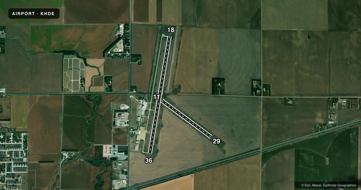
Runways & pattern
Full pagePattern entry · RWY 36
LEFT TRAFFIC| Runway | Heading (°M) | Length | Surface | Traffic |
|---|---|---|---|---|
| 18/36Favored | 183° / 3° | 4,701 ft | ASPH-CONC | Standard L |
| 11/29 | 119° / 299° | 2,429 ft | TURF | Standard L |
Runway end performance
| End | TORA | TODA | ASDA | LDA | VGSI | Approach lights | Obstruction |
|---|---|---|---|---|---|---|---|
| 18 | — | — | — | — | PAPI 2-box left(3°) | — | — |
| 36 | — | — | — | — | PAPI 2-box left(3°) | — | — |
Declared distances in feet. TORA = takeoff run available, TODA = takeoff distance, ASDA = accelerate-stop, LDA = landing distance.
Airport sketch
Runways drawn to scale from FAA survey coordinates, rendered over satellite imagery. Not for navigation.
Approaches & charts
Services on the field
Fuel grades, oxygen, maintenance, ramp storage and lighting — as declared to the FAA by the airport operator.
Fuel & services
- Fuel
- 100LLA
- Oxygen (bottled)
- High pressure
- Oxygen (bulk)
- Not available
- Airframe repair
- Major
- Power plant repair
- Major
- Other services
- AGRI,INSTR,RNTL,SURV
Ramp & ground
- Transient storage
- Tie-down
- Hangar
- Landing fee
- No fee published
- Customs
- Not available
- Lighting schedule
- SEE RMK
- Beacon schedule
- SS-SR
- Beacon
- White / Green (civil land)(WG)
- Wind indicator
- Lighted
- Segmented circle
- Yes
Fuel & FBOs
Cheapest 100LL and Jet A on the field and nearby. Always confirm with the FBO before taxi.
Airport notes
Surface conditions, obstructions, local procedures, lighting outages and other notes published with each FAA cycle.
General notes
- WATERFOWL INVOF ARPT.
- EXTENSIVE CROP SPRAYING OPNS INVOF ARPT APR THRU AUG.
- RWY 11/29 NOT PLOWED WINT MONTHS.
- RWY 18 DSGND CALM WND RWY.
- FOR CD CTC DENVER ARTCC AT 303-651-4257.
Lighting notes
- MIRL RWY 18/36 PRESET LOW INTST; TO INCR INTST & ACTVT REIL & PAPI RWYS 18 & 36 - CTAF.
Fuel notes
- 100LL100LL 24 HR SELF SVC FUEL AVBL VIA CREDIT CARD SYSTEM.
- ACALL FOR JET A SERVICE. FOR SERVICE AND ATTENDANT AFTER HOURS CALL 308-995-7895. IF NO ANSWER, CALL 308-991-5803.
Approach & departure obstructions
- 11RWY 11 /29 MKD; BOUNDARY CONES ON RWY ENDS.
- 18RWY 18 CNTR PIVOTS ROTN THRU APCH CAN CREATE SLOPE AS LOW AS 15:1 DURG IRRIGATION SEASON.
- 18RWY 18 CTLG OBSTN CENTER PIVOT IRRIGATOR ROTATES THROUGH APCH DURING IRRIGATION SEASON
Other notes
- AVIATORS BREATHING OXYGEN 2000 PSI - BOTTLES CAN BE TOPPED OFF
- OWNERDOROTHY ANDERSON CHAIRMAN.
- RNTLAIRCRAFT RENTALS FROM INSTRUCTORS ONLY
- 18/36S 3100 FT & CENTER 50 FT ASPH.
VFR map & nearby airports
VFR sectional. Tap any ICAO chip to open that airport.
Key facts · KHDE
Answer card- ICAO
- KHDE
- Name
- BREWSTER FLD
- Location
- HOLDREGE, NEBRASKA
- Elevation
- 2,313.7 ft MSL
- Traffic pattern altitude
- 3,313.7 ft MSL (1,000 AGL)
- Control tower
- Non-towered (use CTAF)
- Total runways
- 2
- Longest runway
- 18/36 · 4,701 ft
- Published ILS approaches
- 0
- Published frequencies
- 2
- Magnetic variation
- 7°
- Current flight rules
- VFR
- Current wind
- 350° at 3 kt
- Favored runway now
- RWY 36
Brewster Fld is in Holdrege, Nebraska. The field elevation is 2,313.7 ft MSL. It has two runways. The longest is runway 18/36 at 4,701 ft. Runway 11/29 is turf at 2,429 ft. This is an unattended field with no control tower. CTAF and UNICOM are both 122.8. No ILS approaches are published.
Pattern altitude is not published. Use the standard 1,000 ft AGL unless the current Chart Supplement says otherwise. That puts the light-aircraft pattern near 3,314 ft MSL based on the field elevation, but verify before you fly. Holdrege Aviation is on the field. It carries 100LL and Jet A Prist. 100LL 24-hour self-service fuel is available by credit card. For Jet A service, call ahead. The published remarks also note waterfowl in the area. Crop spraying is common from April through August. Runway 18 is the calm wind runway. Runway 18 also has a center pivot irrigator that can move through the approach during irrigation season. That is the main operational item to brief before arrival.