METAR & TAF 37V
37V does not publish a METAR.
Showing the nearest reporting station: KCSB (CAMBRIDGE MUNI) · 11.8 NM away. Conditions at 37V may differ.
METAR · KCSB
Observed 06:15Z
KCSB 270615Z AUTO 21006KT 10SM CLR 30/19 A2980 RMK AO2
- Wind
- 210° @ 6 kt
- Visibility
- 10 SM
- Temp / Dew
- 30°C / 19°C
- Altimeter
- 29.80 inHg
- Clouds
- CLR
- Density alt
- 4,767 ft
- Ceiling
- Unlimited
- Rules
- VFR
Airport info & contacts
Manager on record, flight service, ARTCC, attendance schedule and pattern altitude — published by the FAA and refreshed every 28 days.
Location
- From city
- 2 NM N
- VFR sectional
- OMAHA
- ARTCC
- ZDV · DENVER
- NOTAM facility
- OLU (NOTAM-D)
Airport manager
- Name
- TODD WEVERKA
- Phone
- (308) 999-0073
- Address
- P.O. BOX 331, ARAPAHOE NE 68922-0331
Flight service · Hours
- FSS OLU
- COLUMBUS1-800-WX-BRIEF
- Attendance
- UNATTENDED
Frequencies
Tap any row to copy the frequency to your clipboard.
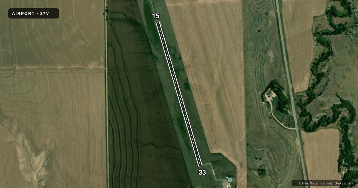
Runways & pattern
Full pagePattern entry · RWY 15
LEFT TRAFFICAirport sketch
Runways drawn to scale from FAA survey coordinates, rendered over satellite imagery. Not for navigation.
Approaches & charts
Services on the field
Fuel grades, oxygen, maintenance, ramp storage and lighting — as declared to the FAA by the airport operator.
Fuel & services
- Fuel
- 100LL
- Oxygen (bottled)
- Not available
- Oxygen (bulk)
- Not available
- Airframe repair
- Not available
- Power plant repair
- Not available
Ramp & ground
- Transient storage
- Tie-down
- Hangar
- Landing fee
- No fee published
- Beacon schedule
- SS-SR
- Beacon
- White / Green (civil land)(WG)
- Wind indicator
- Yes
- Segmented circle
- No
Fuel & FBOs
Cheapest 100LL and Jet A on the field and nearby. Always confirm with the FBO before taxi.
Airport notes
Surface conditions, obstructions, local procedures, lighting outages and other notes published with each FAA cycle.
General notes
- FOR CD CTC DENVER ARTCC AT 303-651-4257.
Other notes
- OWNERTODD WEVERKA IS CHAIRMAN OF THE ARAPAHOE AIRPORT AUTHORITY (BS 7/2013)
VFR map & nearby airports
VFR sectional. Tap any ICAO chip to open that airport.
Key facts · 37V
Answer card- ICAO
- 37V
- Name
- ARAPAHOE MUNI
- Location
- ARAPAHOE, NEBRASKA
- Elevation
- 2,273 ft MSL
- Traffic pattern altitude
- 3,273 ft MSL (1,000 AGL)
- Control tower
- Non-towered (use CTAF)
- Total runways
- 1
- Longest runway
- 15/33 · 3,000 ft
- Published ILS approaches
- 0
- Published frequencies
- 1
- Magnetic variation
- 8°
- Current flight rules
- VFR
- Current wind
- 210° at 6 kt
- Favored runway now
- RWY 15
Arapahoe Muni sits in Arapahoe, Nebraska. The field elevation is 2,273 ft MSL. It has one runway. Runway 15/33 is 3,000 ft asphalt with magnetic headings 163° and 343°. There is no control tower. CTAF is 122.9.
No ILS approaches are published here. Pattern altitude is not published, so use standard 1,000 ft AGL unless the current FAA Chart Supplement says otherwise. That puts the light piston pattern at 3,273 ft MSL based on the field elevation. The airport is in a rural part of Nebraska. Density altitude can still matter in warm weather because of the elevation. Plan takeoff and landing performance with that in mind.
No on-field FBOs are listed in the facts. Contact the airport operator directly before arrival, or call the field on CTAF for current FBO availability. The published remarks also note that clearance delivery is handled through Denver ARTCC at 303-651-4257. If you need IFR handling or local airport details, verify them with the current FAA Chart Supplement before you go.