METAR & TAF KMCK
Current METAR
Observed 12:53Z
KMCK 271253Z AUTO 04009KT 10SM CLR 29/22 A2986 RMK AO2 SLP072 T02890217
- Wind
- 040° @ 9 kt
- Visibility
- 10 SM
- Temp / Dew
- 29°C / 22°C
- Altimeter
- 29.86 inHg
- Clouds
- CLR
- Density alt
- 4,957 ft
- Ceiling
- Unlimited
- Rules
- VFR
Airport info & contacts
Manager on record, flight service, ARTCC, attendance schedule and pattern altitude — published by the FAA and refreshed every 28 days.
Location
- From city
- 2 NM E
- VFR sectional
- OMAHA
- ARTCC
- ZDV · DENVER
- NOTAM facility
- MCK (NOTAM-D)
Airport manager
- Name
- MR. NATE SCHNEIDER
- Phone
- 308-345-2022
- Address
- BOX 1059, MC COOK NE 69001
Flight service · Hours
- FSS OLU
- COLUMBUS1-800-WX-BRIEF
- Attendance
- DALGT
Frequencies
Tap any row to copy the frequency to your clipboard.
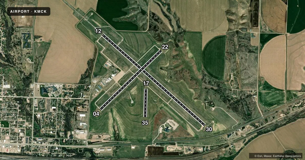
Runways & pattern
Full pagePattern entry · RWY 04
RIGHT TRAFFIC| Runway | Heading (°M) | Length | Surface | Traffic |
|---|---|---|---|---|
| 12/30 | 123° / 303° | 6,450 ft | CONC | 30 R |
| 04/22Favored | 38° / 218° | 4,000 ft | CONC | 04 R |
| 17/35 | 173° / 353° | 1,330 ft | TURF | 35 R |
Runway end performance
| End | TORA | TODA | ASDA | LDA | VGSI | Approach lights | Obstruction |
|---|---|---|---|---|---|---|---|
| 12 | 6,448' | 6,448' | 5,698' | 5,698' | PAPI 4-box left(3°) | MALSR | 30', tree, 1225' from thr, 475' R of cntrln, slope 34 |
| 30 | 6,448' | 6,448' | 6,448' | 5,698' | VASI 4-box left(3°) | — | — |
| 04 | 4,000' | 4,000' | 4,000' | 4,000' | VASI 2-box left(3°) | — | 25', pole, 850' from thr, 100' R of cntrln, slope 26 |
| 22 | 4,000' | 4,000' | 4,000' | 4,000' | VASI 2-box left(3°) | — | — |
Declared distances in feet. TORA = takeoff run available, TODA = takeoff distance, ASDA = accelerate-stop, LDA = landing distance.
Airport sketch
Runways drawn to scale from FAA survey coordinates, rendered over satellite imagery. Not for navigation.
Approaches & charts
ILS · 1
Services on the field
Fuel grades, oxygen, maintenance, ramp storage and lighting — as declared to the FAA by the airport operator.
Fuel & services
- Fuel
- 100LLA
- Oxygen (bottled)
- Not available
- Oxygen (bulk)
- Not available
- Airframe repair
- Major
- Power plant repair
- Major
- Other services
- AGRI,AMB,CHTR,INSTR,RNTL,SALES
Ramp & ground
- Transient storage
- Tie-down
- Hangar
- Landing fee
- No fee published
- Customs
- Not available
- Lighting schedule
- SEE RMK
- Beacon schedule
- SS-SR
- Beacon
- White / Green (civil land)(WG)
- Wind indicator
- Lighted
- Segmented circle
- Yes
Fuel & FBOs
Cheapest 100LL and Jet A on the field and nearby. Always confirm with the FBO before taxi.
Airport notes
Surface conditions, obstructions, local procedures, lighting outages and other notes published with each FAA cycle.
General notes
- FOR CD CTC DENVER ARTCC ON FREQ. IF UNA, CTC FSS ON FREQ VIA RCO. IF UNA, CTC DENVER ARTCC AT 303-651-4257.
- ACTVT MALSR RWY 12; PAPI RWY 12; & VASI RWY 30 - CTAF.
Lighting notes
- ACTVT VASI RY 30 & PAPI RY 12 & MALSR RY 12 - CTAF.
Runway surface & condition
- 04/22PCR VALUE: 90/R/B/W/T
- 12/30PCR VALUE: 90/R/B/W/T
- 17/35RWY 17/35 NOT AVBL FOR PART 121/PART 380 OPS WITH SKED PAX CARRYING OPS MORE THAN 9 PAX SEATS AND NON-SKED PAX CARRYING OPS MORE THAN 30 PAX SEATS.
Approach & departure obstructions
- 1717/35 THR BDRY MKRS.
- 12UNUSBL BYD 5 DEGS RIGHT OF CNTRLN AND 8 DEGS LEFT OF CNTRLN.
Other notes
- MANAGERCITY MANAGER.
VFR map & nearby airports
VFR sectional. Tap any ICAO chip to open that airport.
Key facts · KMCK
Answer card- ICAO
- KMCK
- Name
- MC COOK BEN NELSON RGNL
- Location
- MC COOK, NEBRASKA
- Elevation
- 2,582.9 ft MSL
- Traffic pattern altitude
- 3,582.9 ft MSL (1,000 AGL)
- Control tower
- Non-towered (use CTAF)
- Total runways
- 3
- Longest runway
- 12/30 · 6,450 ft
- Published ILS approaches
- 1
- Published frequencies
- 2
- Magnetic variation
- 8°
- Current flight rules
- VFR
- Current wind
- 040° at 9 kt
- Favored runway now
- RWY 04
Mc Cook Ben Nelson Rgnl Airport sits in Mc Cook, Nebraska. Field elevation is 2,582.9 ft MSL. The airport has three runways. The longest is runway 12/30 at 6,450 ft. There is no control tower, so plan to self-announce on CTAF 122.8. Pattern altitude is not published. Use 1,000 ft AGL for light piston operations unless the current Chart Supplement says otherwise.
Runway 12 has the ILS and the published approach lighting. Runway 12 also has PAPI, while runway 30 has VASI. The field is high enough that density altitude can matter on warm days. Takeoff and climb performance deserve a close look. Runway 12 is also noted as unusable beyond 5 degrees right of centerline and 8 degrees left of centerline. Runway 17/35 is turf and is not available for certain large scheduled passenger operations.
Red Willow Aviation is on the field. It carries 100LL and Jet A. For clearance delivery, the Chart Supplement says to contact Denver ARTCC on frequency. If that is not available, use Flight Service via RCO or call Denver ARTCC directly. The airport manager is the city manager.