METAR & TAF 47V
47V does not publish a METAR.
Showing the nearest reporting station: KCSB (CAMBRIDGE MUNI) · 24.5 NM away. Conditions at 47V may differ.
METAR · KCSB
Observed 15:15Z
KCSB 261515Z AUTO VRB04KT 10SM CLR 31/22 A2990 RMK AO2
- Wind
- VAR @ 4 kt
- Visibility
- 10 SM
- Temp / Dew
- 31°C / 22°C
- Altimeter
- 29.90 inHg
- Clouds
- CLR
- Density alt
- 5,265 ft
- Ceiling
- Unlimited
- Rules
- VFR
Airport info & contacts
Manager on record, flight service, ARTCC, attendance schedule and pattern altitude — published by the FAA and refreshed every 28 days.
Location
- From city
- 2 NM E
- VFR sectional
- OMAHA
- ARTCC
- ZDV · DENVER
- NOTAM facility
- OLU (NOTAM-D)
Airport manager
- Name
- TOM BROWN
- Phone
- (308) 367-7352
- Address
- PO BOX 131, CURTIS NE 69025-0131
Flight service · Hours
- FSS OLU
- COLUMBUS1-800-WX-BRIEF
- Attendance
- Unattended
Frequencies
Tap any row to copy the frequency to your clipboard.
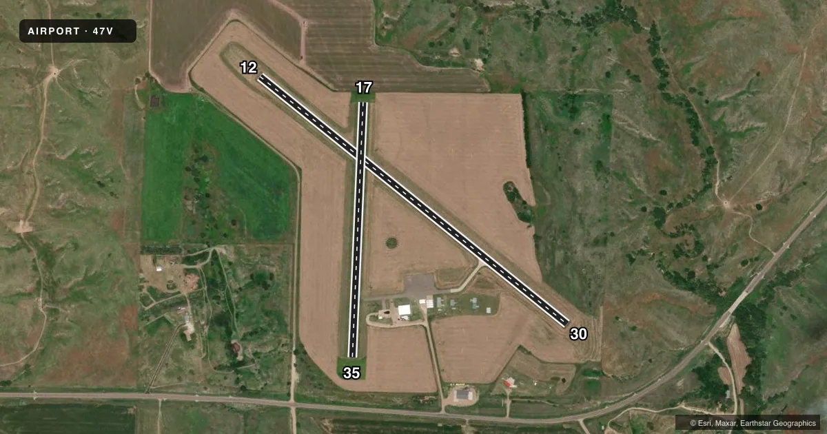
Runways & pattern
Full pagePattern entry · RWY 35
LEFT TRAFFICAirport sketch
Runways drawn to scale from FAA survey coordinates, rendered over satellite imagery. Not for navigation.
Approaches & charts
Services on the field
Fuel grades, oxygen, maintenance, ramp storage and lighting — as declared to the FAA by the airport operator.
Fuel & services
- Fuel
- 100LL
- Oxygen (bottled)
- Not available
- Oxygen (bulk)
- Not available
Ramp & ground
- Transient storage
- Tie-down
- Hangar
- Landing fee
- No fee published
- Customs
- Not available
- Lighting schedule
- SEE RMK
- Beacon schedule
- SS-SR
- Beacon
- White / Green (civil land)(WG)
- Wind indicator
- Lighted
- Segmented circle
- Yes
Fuel & FBOs
Cheapest 100LL and Jet A on the field and nearby. Always confirm with the FBO before taxi.
Airport notes
Surface conditions, obstructions, local procedures, lighting outages and other notes published with each FAA cycle.
General notes
- FOR CD CTC DENVER ARTCC AT 303-651-4257.
Lighting notes
- ACTVT MIRL RY 12/30 - CTAF.
Fuel notes
- 100LLFOR FUEL AFT HRS & UNATNDD DAYS CALL AMGR (308) 367-7352.
Runway surface & condition
- 17/35RY 17/35 MKD WITH YELLOW CONES.
Approach & departure obstructions
- 12CROPS 5 FT TALL ON BOTH SIDES OF THE RWY, 125 FT L & R AND GOING OUT TO 250 FT L & R FM RWY END.
- 30CROPS 5 FT TALL AT THE END OF RWY, 125 FT L AND EXTDG TO 250 FT L.
- 17OBSTRUCTION MAY BE CROPS DURING GROWING SEASON.
Other notes
- EXISTED PRIOR TO 1959.
- OWNERRYAN PATE, CHAIRMAN OF AIRPORT AUTHORITY.
VFR map & nearby airports
VFR sectional. Tap any ICAO chip to open that airport.
Key facts · 47V
Answer card- ICAO
- 47V
- Name
- CURTIS MUNI
- Location
- CURTIS, NEBRASKA
- Elevation
- 2,677.4 ft MSL
- Traffic pattern altitude
- 3,677.4 ft MSL (1,000 AGL)
- Control tower
- Non-towered (use CTAF)
- Total runways
- 2
- Longest runway
- 12/30 · 3,402 ft
- Published ILS approaches
- 0
- Published frequencies
- 1
- Magnetic variation
- 6°
- Current flight rules
- VFR
- Current wind
- 000° at 4 kt
- Favored runway now
- RWY 35
Curtis Muni sits in Curtis, Nebraska. The field elevation is 2,677.4 ft MSL. It has two runways. The longest is runway 12/30 at 3,402 ft. There is no control tower. CTAF is 122.9. No ILS approaches are published here. Pattern altitude is not published, so use standard 1,000 ft AGL for light piston traffic unless the current Chart Supplement says otherwise.
The on-field FBO is Curtis Municipal Airport. It carries 100LL. Call (308) 367-7352 for fuel after hours or on unattended days. Runway 12/30 has medium intensity lights that are activated by CTAF. That helps for night work on the paved runway. Runway 17/35 is turf and is marked with yellow cones.
Plan for crop-related obstacles near the turf and paved ends. Published remarks note crops near runway 17 during the growing season. They also note crops near runway 30. Crops are on both sides of runway 12 extending away from the runway end. This is a field where a careful preflight and a close look at the current Chart Supplement matter. For IFR clearance delivery, contact Denver ARTCC at (303) 651-4257. If you need any local operating detail that is not published, call the airport manager or the FBO directly before you go.