METAR & TAF KGTE
KGTE does not publish a METAR.
Showing the nearest reporting station: KLXN (JIM KELLY FLD) · 18.7 NM away. Conditions at KGTE may differ.
METAR · KLXN
Observed 15:15Z
KLXN 271515Z AUTO 06010KT 10SM CLR 30/26 A2986 RMK AO2 T03040258
- Wind
- 060° @ 10 kt
- Visibility
- 10 SM
- Temp / Dew
- 30°C / 26°C
- Altimeter
- 29.86 inHg
- Clouds
- CLR
- Density alt
- 5,047 ft
- Ceiling
- Unlimited
- Rules
- VFR
Airport info & contacts
Manager on record, flight service, ARTCC, attendance schedule and pattern altitude — published by the FAA and refreshed every 28 days.
Location
- From city
- 1 NM E
- VFR sectional
- OMAHA
- ARTCC
- ZDV · DENVER
- NOTAM facility
- OLU (NOTAM-D)
Airport manager
- Name
- GARY GREER
- Phone
- 308-529-2594
- Address
- P.O. BOX 267, GOTHENBURG NE 69138-0267
Flight service · Hours
- FSS OLU
- COLUMBUS1-800-WX-BRIEF
- Attendance
- Unattended
Frequencies
Tap any row to copy the frequency to your clipboard.
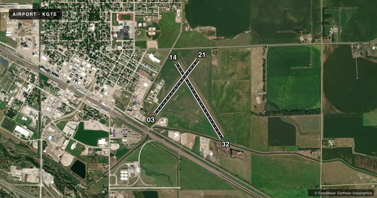
Runways & pattern
Full pagePattern entry · RWY 03
LEFT TRAFFIC| Runway | Heading (°M) | Length | Surface | Traffic |
|---|---|---|---|---|
| 14/32 | 141° / 321° | 3,300 ft | TURF | Standard L |
| 03/21Favored | 30° / 210° | 2,599 ft | CONC | Standard L |
Runway end performance
| End | TORA | TODA | ASDA | LDA | VGSI | Approach lights | Obstruction |
|---|---|---|---|---|---|---|---|
| 03 | — | — | — | — | — | — | 11', other, 279' from thr, 170' R of cntrln, slope 7 |
| 21 | — | — | — | — | — | — | 19', road, 353' from thr, 273' R of cntrln, slope 8 |
Declared distances in feet. TORA = takeoff run available, TODA = takeoff distance, ASDA = accelerate-stop, LDA = landing distance.
Airport sketch
Runways drawn to scale from FAA survey coordinates, rendered over satellite imagery. Not for navigation.
Approaches & charts
Services on the field
Fuel grades, oxygen, maintenance, ramp storage and lighting — as declared to the FAA by the airport operator.
Fuel & services
- Fuel
- 100LL
- Oxygen (bottled)
- Not available
- Oxygen (bulk)
- Not available
Ramp & ground
- Transient storage
- Tie-down
- Hangar
- Landing fee
- No fee published
- Customs
- Not available
- Lighting schedule
- SEE RMK
- Beacon schedule
- SS-SR
- Beacon
- White / Green (civil land)(WG)
- Wind indicator
- Lighted
- Segmented circle
- No
Fuel & FBOs
Cheapest 100LL and Jet A on the field and nearby. Always confirm with the FBO before taxi.
Airport notes
Surface conditions, obstructions, local procedures, lighting outages and other notes published with each FAA cycle.
General notes
- RWY 14/32 NOT PLOWED WINTER MONTHS.
- MIGRATORY BIRDS INVOF APRT SPRING AND FALL.
- FOR CD CTC DENVER ARTCC AT 303-651-4257.
Lighting notes
- ACTVT MIRL RWY 03/21 - CTAF.
Fuel notes
- 100LLFUEL AVBL H24 VIA CREDIT CARD.
Approach & departure obstructions
- 03CTLG OBSTN FM DEP THR IS TWR 2157 FT OUT, 107 FT ABV, 514 FT R, CLNC SLP 20:1.
- 03OBSTN IS SEMI TRAILER, CLNC SLP IS 31:1 FM DEP THR.
Other notes
- EXISTED PRIOR TO 1959.
- OWNERCHAIRMAN OF ARPT AUTH; ROGER TEDERMAN.
VFR map & nearby airports
VFR sectional. Tap any ICAO chip to open that airport.
Key facts · KGTE
Answer card- ICAO
- KGTE
- Name
- GOTHENBURG MUNI
- Location
- GOTHENBURG, NEBRASKA
- Elevation
- 2,558.8 ft MSL
- Traffic pattern altitude
- 3,558.8 ft MSL (1,000 AGL)
- Control tower
- Non-towered (use CTAF)
- Total runways
- 2
- Longest runway
- 14/32 · 3,300 ft
- Published ILS approaches
- 0
- Published frequencies
- 2
- Magnetic variation
- 8°
- Current flight rules
- VFR
- Current wind
- 060° at 10 kt
- Favored runway now
- RWY 03
Gothenburg Muni is in Gothenburg, Nebraska. The field elevation is 2,558.8 ft MSL. It has 2 runways. The longest is runway 14/32 at 3,300 ft. There is no control tower, so expect self-announce traffic on CTAF 122.8. UNICOM is also 122.8.
No ILS approaches are published here. Pattern altitude is not published in the facts, so use the standard 1,000 ft AGL for light piston traffic unless the current FAA Chart Supplement says otherwise. That puts the pattern at about 3,558.8 ft MSL based on the field elevation. Runway 03/21 has medium intensity lights that are activated by CTAF. The airport also has 100LL available 24 hours by credit card. No on-field FBOs are listed.
A few operational notes matter here. Runway 14/32 is not plowed during winter months. There is a semi trailer near the departure end of runway 03 with a steep clearance slope. A tower is also charted off runway 03. Migratory birds are in the area during spring and fall. For clearance delivery, contact Denver ARTCC at 303-651-4257. If you are planning a first stop here, review the current FAA Chart Supplement before departure and pay close attention to runway 03 departure planning.