METAR & TAF KBBW
Current METAR
Observed 15:53Z
KBBW 271553Z AUTO 04008G19KT 10SM CLR 32/26 A2988 RMK AO2 SLP088 T03170261 $
- Wind
- 040° @ 8G19 kt
- Visibility
- 10 SM
- Temp / Dew
- 32°C / 26°C
- Altimeter
- 29.88 inHg
- Clouds
- CLR
- Density alt
- 5,247 ft
- Ceiling
- Unlimited
- Rules
- VFR
Airport info & contacts
Manager on record, flight service, ARTCC, attendance schedule and pattern altitude — published by the FAA and refreshed every 28 days.
Location
- From city
- 2 NM N
- VFR sectional
- OMAHA
- ARTCC
- ZDV · DENVER
- NOTAM facility
- BBW (NOTAM-D)
Airport manager
- Name
- BROKEN BOW AIRPORT AUTHORITY
- Phone
- 308-870-3354
- Address
- PO BOX 672, BROKEN BOW NE 68822-0672
Flight service · Hours
- FSS OLU
- COLUMBUS1-800-WX-BRIEF
- Attendance
- UNATTENDED
Frequencies
Tap any row to copy the frequency to your clipboard.
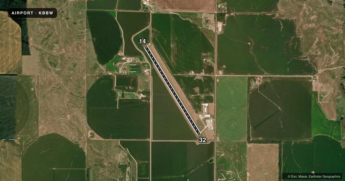
Runways & pattern
Full pagePattern entry · RWY 32
LEFT TRAFFICRunway end performance
| End | TORA | TODA | ASDA | LDA | VGSI | Approach lights | Obstruction |
|---|---|---|---|---|---|---|---|
| 14 | — | — | — | — | PAPI 2-box left(3°) | — | 21', road, 620' from thr, 0' R of cntrln, slope 20 |
| 32 | — | — | — | — | PAPI 2-box left(3°) | — | — |
Declared distances in feet. TORA = takeoff run available, TODA = takeoff distance, ASDA = accelerate-stop, LDA = landing distance.
Airport sketch
Runways drawn to scale from FAA survey coordinates, rendered over satellite imagery. Not for navigation.
Approaches & charts
Services on the field
Fuel grades, oxygen, maintenance, ramp storage and lighting — as declared to the FAA by the airport operator.
Fuel & services
- Fuel
- 100LLA
- Oxygen (bottled)
- Not available
- Oxygen (bulk)
- Not available
- Airframe repair
- Not available
- Power plant repair
- Not available
- Other services
- AGRI,INSTR
Ramp & ground
- Transient storage
- Tie-down
- Hangar
- Landing fee
- No fee published
- Customs
- Not available
- Lighting schedule
- SEE RMK
- Beacon schedule
- SS-SR
- Beacon
- White / Green (civil land)(WG)
- Wind indicator
- Lighted
- Segmented circle
- No
Fuel & FBOs
Cheapest 100LL and Jet A on the field and nearby. Always confirm with the FBO before taxi.
Airport notes
Surface conditions, obstructions, local procedures, lighting outages and other notes published with each FAA cycle.
General notes
- COURTESY CARS AVBL.
- FOR CD CTC DENVER ARTCC AT 303-651-4257.
Lighting notes
- ACTVT REIL RWY 14; PAPI RWY 14 & 32; MIRL RWY 14/32 - CTAF.
Fuel notes
- 100LL24 HR SELF SERV FUEL AVBL VIA CREDIT CARD SYSTEM FOR 100LL.
- AJET A AVBL BY PRIOR ARRANGEMENT.
Other notes
- 1FOR SVC CALL NRS LISTED ON NOTICE IN TERMINAL BLDG
VFR map & nearby airports
VFR sectional. Tap any ICAO chip to open that airport.
Key facts · KBBW
Answer card- ICAO
- KBBW
- Name
- BROKEN BOW MUNI/KEITH GLAZE FLD
- Location
- BROKEN BOW, NEBRASKA
- Elevation
- 2,546.3 ft MSL
- Traffic pattern altitude
- 3,546.3 ft MSL (1,000 AGL)
- Control tower
- Non-towered (use CTAF)
- Total runways
- 1
- Longest runway
- 14/32 · 4,203 ft
- Published ILS approaches
- 0
- Published frequencies
- 2
- Magnetic variation
- 8°
- Current flight rules
- VFR
- Current wind
- 040° at 8 kt
- Favored runway now
- RWY 32
Broken Bow Muni/Keith Glaze Fld (KBBW) sits in Broken Bow, Nebraska. Field elevation is 2,546.3 ft MSL. The airport has one runway. Runway 14/32 is 4,203 ft long with concrete pavement. The field is non-towered. CTAF and UNICOM are both 122.8.
No ILS approaches are published here. Pattern altitude is not published in the facts, so plan on the standard 1,000 ft AGL for light piston traffic unless the current Chart Supplement says otherwise. The on-field FBO is Broken Bow Municipal Airport. It carries 100LL and Jet A Prist. Jet A is available by prior arrangement. Twenty-four hour self-serve 100LL is available by credit card system.
Runway 14 has runway end identifier lights, PAPI and medium intensity runway lights. Runway 32 also has PAPI and medium intensity runway lights. One published caution is corn 2 ft to 4 ft above runway elevation near Runway 14. That matters on short final and during rollout. For clearance delivery, contact Denver ARTCC at 303-651-4257. Courtesy car and van are available. If you need current operational details or any local restrictions, check the current FAA Chart Supplement or call the airport operator before departure.