METAR & TAF 0F4
0F4 does not publish a METAR.
Showing the nearest reporting station: KODX (EVELYN SHARP FLD) · 20.3 NM away. Conditions at 0F4 may differ.
METAR · KODX
Observed 05:53Z
KODX 270553Z AUTO 31007KT 9SM CLR 26/26 A2980 RMK AO2 SLP071 T02610261 10356 20261 403670211 51006 $
- Wind
- 310° @ 7 kt
- Visibility
- 9 SM
- Temp / Dew
- 26°C / 26°C
- Altimeter
- 29.80 inHg
- Clouds
- CLR
- Density alt
- 4,039 ft
- Ceiling
- Unlimited
- Rules
- VFR
Airport info & contacts
Manager on record, flight service, ARTCC, attendance schedule and pattern altitude — published by the FAA and refreshed every 28 days.
Location
- From city
- 1 NM NW
- VFR sectional
- OMAHA
- ARTCC
- ZMP · MINNEAPOLIS
- NOTAM facility
- OLU (NOTAM-D)
Airport manager
- Name
- MIKE KING
- Phone
- 308-390-1500
- Address
- PO BOX 29, LOUP CITY NE 68853-0029
Flight service · Hours
- FSS OLU
- COLUMBUS1-800-WX-BRIEF
- Attendance
- Unattended
Frequencies
Tap any row to copy the frequency to your clipboard.
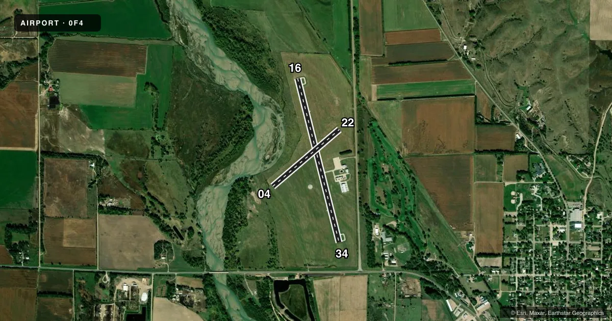
Runways & pattern
Full pagePattern entry · RWY 34
LEFT TRAFFIC| Runway | Heading (°M) | Length | Surface | Traffic |
|---|---|---|---|---|
| 16/34Favored | 161° / 341° | 3,900 ft | CONC | Standard L |
| 04/22 | 45° / 225° | 2,021 ft | TURF | Standard L |
Runway end performance
| End | TORA | TODA | ASDA | LDA | VGSI | Approach lights | Obstruction |
|---|---|---|---|---|---|---|---|
| 16 | — | — | — | — | PAPI 2-box left(3°) | — | — |
| 34 | — | — | — | — | PAPI 2-box left(3°) | — | — |
| 04 | — | — | — | — | — | — | 56', trees, 981' from thr, 178' R of cntrln, slope 17 |
| 22 | — | — | — | — | — | — | 32', tree, 475' from thr, 101' R of cntrln, slope 14 |
Declared distances in feet. TORA = takeoff run available, TODA = takeoff distance, ASDA = accelerate-stop, LDA = landing distance.
Airport sketch
Runways drawn to scale from FAA survey coordinates, rendered over satellite imagery. Not for navigation.
Approaches & charts
Services on the field
Fuel grades, oxygen, maintenance, ramp storage and lighting — as declared to the FAA by the airport operator.
Fuel & services
- Fuel
- 100LL
- Oxygen (bottled)
- Not available
- Oxygen (bulk)
- Not available
- Airframe repair
- Not available
- Power plant repair
- Not available
- Other services
- AGRI
Ramp & ground
- Transient storage
- Tie-down
- Hangar
- Landing fee
- No fee published
- Customs
- Not available
- Lighting schedule
- SEE RMK
- Beacon schedule
- SS-SR
- Beacon
- White / Green (civil land)(WG)
- Wind indicator
- Lighted
- Segmented circle
- Yes
Fuel & FBOs
Cheapest 100LL and Jet A on the field and nearby. Always confirm with the FBO before taxi.
Airport notes
Surface conditions, obstructions, local procedures, lighting outages and other notes published with each FAA cycle.
General notes
- FOR CD CTC MINNEAPOLIS ARTCC AT 651-463-5588.
Lighting notes
- MIRL RWY 16/34 LOW INTST SS-SR; TO INCREASE - CTAF. PAPI RWY 16 & 34 - CTAF
Fuel notes
- 100LLFUEL AVBL H24 VIA CREDIT CARD.
Approach & departure obstructions
- 34CLNC SLP 26:1 ALSO DUE TO ROAD 631 FT OUT 16 FT ABV 0B.
Other notes
- CALL AHD FOR TNST HNGR SPACE AMGR.
- 1FOR SVC CALL 308-745-1244.
VFR map & nearby airports
VFR sectional. Tap any ICAO chip to open that airport.
Key facts · 0F4
Answer card- ICAO
- 0F4
- Name
- LOUP CITY MUNI
- Location
- LOUP CITY, NEBRASKA
- Elevation
- 2,072.6 ft MSL
- Traffic pattern altitude
- 3,072.6 ft MSL (1,000 AGL)
- Control tower
- Non-towered (use CTAF)
- Total runways
- 2
- Longest runway
- 16/34 · 3,900 ft
- Published ILS approaches
- 0
- Published frequencies
- 1
- Magnetic variation
- 5°
- Current flight rules
- VFR
- Current wind
- 310° at 7 kt
- Favored runway now
- RWY 34
Loup City Muni sits in Loup City, Nebraska. The field elevation is 2,072.6 ft MSL. It has two runways. The longest is 3,900 ft of concrete on 16/34. The turf runway 04/22 is 2,021 ft. This is an untowered field. CTAF is 122.9.
No ILS approaches are published here. Pattern altitude is not published in the facts, so use the standard 1,000 ft AGL unless the current Chart Supplement says otherwise. The airport sits in open country, so expect normal Nebraska wind and density altitude planning on warm days at this elevation.
The on-field FBO is Loup City Municipal Airport. It carries 100LL. Fuel is available 24 hours a day by credit card. Call ahead for transient hangar space if you need it. The published remarks also note that runway 16/34 lights run at low intensity from sunset to sunrise. Use the CTAF to increase intensity. The PAPI on 16 and 34 is also CTAF controlled. There is an obstruction note for runway 34. The clearance slope is 26 to 1. A road sits 631 ft from the threshold and is 16 ft above airport elevation. If you need clearance delivery, contact Minneapolis ARTCC. For service, use the published phone number before arrival.