METAR & TAF KBUB
KBUB does not publish a METAR.
Showing the nearest reporting station: KODX (EVELYN SHARP FLD) · 12.8 NM away. Conditions at KBUB may differ.
METAR · KODX
Observed 15:53Z
KODX 271553Z AUTO 04014G19KT 10SM CLR 33/28 A2984 RMK AO2 SLP086 T03330283 $
- Wind
- 040° @ 14G19 kt
- Visibility
- 10 SM
- Temp / Dew
- 33°C / 28°C
- Altimeter
- 29.84 inHg
- Clouds
- CLR
- Density alt
- 4,966 ft
- Ceiling
- Unlimited
- Rules
- VFR
Airport info & contacts
Manager on record, flight service, ARTCC, attendance schedule and pattern altitude — published by the FAA and refreshed every 28 days.
Location
- From city
- 1 NM SW
- VFR sectional
- OMAHA
- ARTCC
- ZDV · DENVER
- NOTAM facility
- OLU (NOTAM-D)
Airport manager
- Name
- DUANE BROCKMAN
- Phone
- (308) 214-0635
- Address
- PO BOX 730, BURWELL NE 68823-0730
Flight service · Hours
- FSS OLU
- COLUMBUS1-800-WX-BRIEF
- Attendance
- Unattended
Frequencies
Tap any row to copy the frequency to your clipboard.
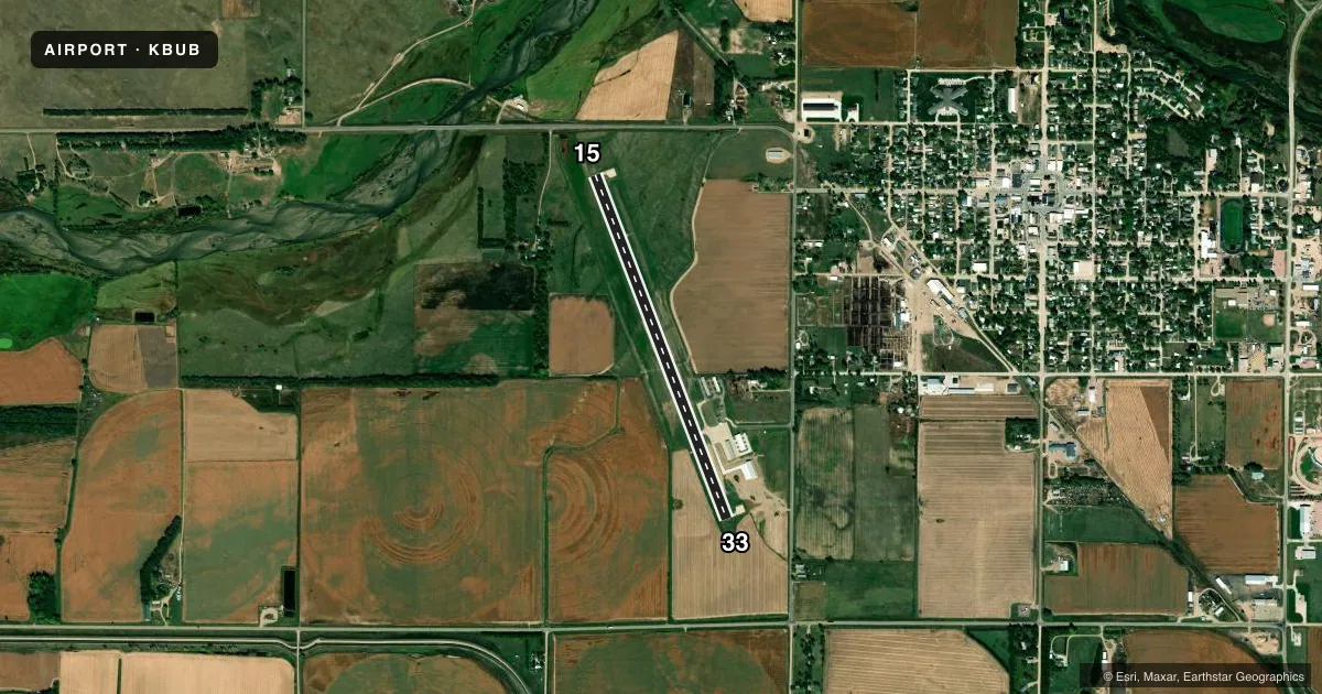
Runways & pattern
Full pagePattern entry · RWY 33
LEFT TRAFFICRunway end performance
| End | TORA | TODA | ASDA | LDA | VGSI | Approach lights | Obstruction |
|---|---|---|---|---|---|---|---|
| 15 | — | — | — | — | PAPI 2-box left(3°) | — | 12', road, 440' from thr, 0' R of cntrln, slope 20 |
| 33 | — | — | — | — | PAPI 2-box left(3°) | — | — |
Declared distances in feet. TORA = takeoff run available, TODA = takeoff distance, ASDA = accelerate-stop, LDA = landing distance.
Airport sketch
Runways drawn to scale from FAA survey coordinates, rendered over satellite imagery. Not for navigation.
Approaches & charts
Services on the field
Fuel grades, oxygen, maintenance, ramp storage and lighting — as declared to the FAA by the airport operator.
Fuel & services
- Fuel
- 100LL
- Oxygen (bottled)
- Not available
- Oxygen (bulk)
- Not available
Ramp & ground
- Transient storage
- Tie-down
- Hangar
- Landing fee
- No fee published
- Customs
- Not available
- Lighting schedule
- SEE RMK
- Beacon schedule
- SS-SR
- Beacon
- White / Green (civil land)(WG)
- Wind indicator
- Lighted
- Segmented circle
- Yes
Fuel & FBOs
Cheapest 100LL and Jet A on the field and nearby. Always confirm with the FBO before taxi.
Airport notes
Surface conditions, obstructions, local procedures, lighting outages and other notes published with each FAA cycle.
General notes
- DEER ON AND INVOF ARPT.
- WATERFOWL ON AND INVOF ARPT.
- CNTR PIVOT IRRIGATION SYS ROTATES THRU LS OF RWY 15 APCH DRG IRRIGATION SEASON
- FOR CD CTC DENVER ARTCC AT 303-651-4257.
Lighting notes
- REIL RWY 15 & 33; PAPI 15 & 33; MIRL RWY 15/33 PRESET ON MED INTST UNTIL 2400; AFT 0000 TO ACTVT AND INCR INTST - CTAF.
Fuel notes
- 100LL24-HR SELF SVC FUEL AVBL VIA CREDIT CARD SYSTEM.
Other notes
- MANAGER(308) 214-0635
VFR map & nearby airports
VFR sectional. Tap any ICAO chip to open that airport.
Key facts · KBUB
Answer card- ICAO
- KBUB
- Name
- CRAM FLD
- Location
- BURWELL, NEBRASKA
- Elevation
- 2,183.3 ft MSL
- Traffic pattern altitude
- 3,183.3 ft MSL (1,000 AGL)
- Control tower
- Non-towered (use CTAF)
- Total runways
- 1
- Longest runway
- 15/33 · 3,900 ft
- Published ILS approaches
- 0
- Published frequencies
- 1
- Magnetic variation
- 7°
- Current flight rules
- VFR
- Current wind
- 040° at 14 kt
- Favored runway now
- RWY 33
CRAM FLD sits in Burwell, Nebraska. The field elevation is 2,183.3 ft MSL. It has one runway, 15/33, which is 3,900 ft long and paved with concrete. There is no control tower. CTAF is 122.9.
No ILS approaches are published here. Pattern altitude is not published, so use the standard 1,000 ft AGL pattern unless the current FAA Chart Supplement says otherwise. That puts the light piston pattern at about 3,183.3 ft MSL. Runway 15/33 has runway end identifier lights, PAPI on both ends and medium intensity runway lights. The lights are preset on medium intensity until 2400. After 0000, they activate and increase intensity on CTAF.
There are no on-field FBOs listed in the facts. 100LL self-serve fuel is available 24 hours by credit card. The published remarks also call out a center pivot irrigation system that can move through the runway 15 approach during irrigation season. Deer and waterfowl are also reported on and near the airport, so keep a sharp scan on arrival and departure. For clearance delivery, contact Denver Air Route Traffic Control Center at 303-651-4257. If you need current local operating details, call the airport manager at (308) 214-0635.