METAR & TAF KRBE
KRBE does not publish a METAR.
Showing the nearest reporting station: KANW (AINSWORTH RGNL) · 18.7 NM away. Conditions at KRBE may differ.
METAR · KANW
Observed 01:15Z
KANW 270115Z AUTO 01007KT 10SM CLR 34/22 A2982 RMK AO2 T03410223
- Wind
- 010° @ 7 kt
- Visibility
- 10 SM
- Temp / Dew
- 34°C / 22°C
- Altimeter
- 29.82 inHg
- Clouds
- CLR
- Density alt
- 5,317 ft
- Ceiling
- Unlimited
- Rules
- VFR
Airport info & contacts
Manager on record, flight service, ARTCC, attendance schedule and pattern altitude — published by the FAA and refreshed every 28 days.
Location
- From city
- 2 NM SW
- VFR sectional
- OMAHA
- ARTCC
- ZDV · DENVER
- NOTAM facility
- OLU (NOTAM-D)
Airport manager
- Name
- BERNIE HART
- Phone
- 402-684-2254
- Address
- 504 S. STATE STREET, BASSETT NE 68714-5046
Flight service · Hours
- FSS OLU
- COLUMBUS1-800-WX-BRIEF
- Attendance
- Unattended
Frequencies
Tap any row to copy the frequency to your clipboard.
Runways & pattern
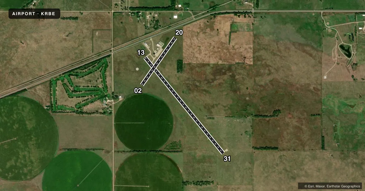
Full pagePattern entry · RWY 02
LEFT TRAFFIC| Runway | Heading (°M) | Length | Surface | Traffic |
|---|---|---|---|---|
| 13/31 | 133° / 313° | 4,698 ft | CONC | Standard L |
| 02/20Favored | 27° / 207° | 2,202 ft | TURF | Standard L |
Runway end performance
| End | TORA | TODA | ASDA | LDA | VGSI | Approach lights | Obstruction |
|---|---|---|---|---|---|---|---|
| 13 | — | — | — | — | PAPI 2-box left(3°) | — | — |
| 31 | — | — | — | — | PAPI 2-box left(3°) | — | 4', fence, 200' from thr, 250' R of cntrln, slope 0 |
| 02 | — | — | — | — | — | — | 79', tree, 1541' from thr, 263' R of cntrln, slope 19 |
Declared distances in feet. TORA = takeoff run available, TODA = takeoff distance, ASDA = accelerate-stop, LDA = landing distance.
Airport sketch
Runways drawn to scale from FAA survey coordinates, rendered over satellite imagery. Not for navigation.
Approaches & charts
Services on the field
Fuel grades, oxygen, maintenance, ramp storage and lighting — as declared to the FAA by the airport operator.
Fuel & services
- Fuel
- 100LL
- Oxygen (bottled)
- Not available
- Oxygen (bulk)
- Not available
- Airframe repair
- Not available
- Power plant repair
- Not available
- Other services
- AGRI
Ramp & ground
- Transient storage
- Tie-down
- Hangar
- Landing fee
- No fee published
- Customs
- Not available
- Lighting schedule
- SEE RMK
- Beacon schedule
- SS-SR
- Beacon
- White / Green (civil land)(WG)
- Wind indicator
- Lighted
- Segmented circle
- Yes
Fuel & FBOs
Cheapest 100LL and Jet A on the field and nearby. Always confirm with the FBO before taxi.
Airport notes
Surface conditions, obstructions, local procedures, lighting outages and other notes published with each FAA cycle.
General notes
- DEER ON & INVOF ARPT.
- (E81) <TURNOFF LGTS ONLY.
- FOR CD CTC DENVER ARTCC AT 303-651-4257.
Lighting notes
- ACTVT MIRL RY 13/31 & PAPI RYS 13 & 31 - CTAF.
Fuel notes
- 100LL24 HR CREDIT CARD
Approach & departure obstructions
- 13RWY 31 CLNC SLOPE ON CTRLN 50:1.
- 13FENCE PARLS RWY CTRLN; 250 FT LEFT TO 400 FT PAST RWY END.
VFR map & nearby airports
VFR sectional. Tap any ICAO chip to open that airport.
Key facts · KRBE
Answer card- ICAO
- KRBE
- Name
- ROCK COUNTY
- Location
- BASSETT, NEBRASKA
- Elevation
- 2,349.4 ft MSL
- Traffic pattern altitude
- 3,349.4 ft MSL (1,000 AGL)
- Control tower
- Non-towered (use CTAF)
- Total runways
- 2
- Longest runway
- 13/31 · 4,698 ft
- Published ILS approaches
- 0
- Published frequencies
- 1
- Magnetic variation
- 8°
- Current flight rules
- VFR
- Current wind
- 010° at 7 kt
- Favored runway now
- RWY 02
Rock County Airport (KRBE) sits near Bassett, Nebraska. Field elevation is 2,349.4 ft MSL. The airport has two runways. The longest is 13/31 at 4,698 ft on concrete. Runway 02/20 is 2,202 ft on turf. There is no control tower. CTAF is 122.9. No ILS approaches are published.
Pattern altitude is not published. For light piston traffic, use the standard 1,000 ft AGL unless the current FAA Chart Supplement or local procedures say otherwise. Rock County Airport carries 100LL through the on-field FBO, Rock County Airport. Fuel is available 24 hours by credit card. The FBO phone is (402) 684-3436.
For a first-time arrival, watch the runway environment closely. Deer are reported on and near the airport. Runway 31 has a centerline clearance slope note. A fence also parallels the runway centerline near runway 13. Medium intensity runway lights are active on 13/31. PAPI is published for runways 13 and 31. For clearance delivery, contact Denver ARTCC at 303-651-4257. If you need current noise, curfew, or local operating details, check the current FAA Chart Supplement or call the airport operator before you go.