METAR & TAF KANW
Current METAR
Observed 15:35Z
KANW 271535Z AUTO 09009KT 10SM CLR 32/25 A2992 RMK AO2 T03150251
- Wind
- 090° @ 9 kt
- Visibility
- 10 SM
- Temp / Dew
- 32°C / 25°C
- Altimeter
- 29.92 inHg
- Clouds
- CLR
- Density alt
- 5,250 ft
- Ceiling
- Unlimited
- Rules
- VFR
Airport info & contacts
Manager on record, flight service, ARTCC, attendance schedule and pattern altitude — published by the FAA and refreshed every 28 days.
Location
- From city
- 6 NM NW
- VFR sectional
- OMAHA
- ARTCC
- ZDV · DENVER
- NOTAM facility
- ANW (NOTAM-D)
Airport manager
- Name
- LANCE SCHIPPOREIT
- Phone
- 402-387-1491
- Address
- PO BOX 84, AINSWORTH NE 69210-0084
Flight service · Hours
- FSS OLU
- COLUMBUS1-800-WX-BRIEF
- Attendance
- MON-FRI · 0800-1700
Frequencies
Tap any row to copy the frequency to your clipboard.
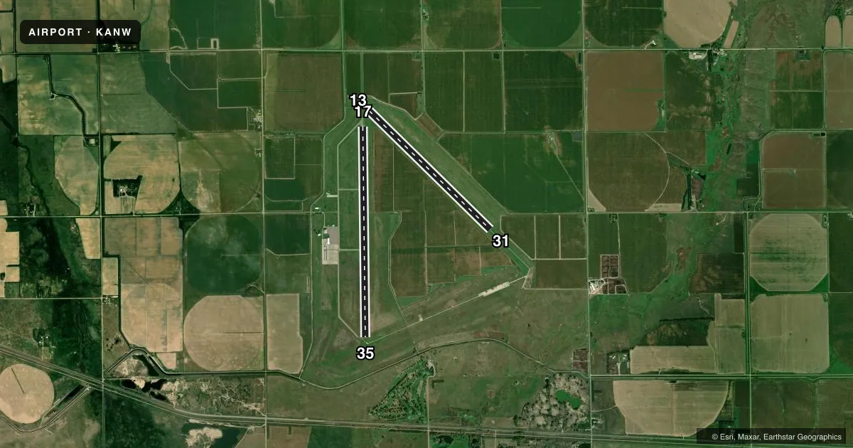
Runways & pattern
Full pagePattern entry · RWY 13
LEFT TRAFFIC| Runway | Heading (°M) | Length | Surface | Traffic |
|---|---|---|---|---|
| 17/35 | 173° / 353° | 6,824 ft | ASPH | Standard L |
| 13/31Favored | 128° / 308° | 5,501 ft | ASPH | Standard L |
Runway end performance
| End | TORA | TODA | ASDA | LDA | VGSI | Approach lights | Obstruction |
|---|---|---|---|---|---|---|---|
| 17 | — | — | — | — | PAPI 4-box left(3°) | MALSR | 5', berm, 347' from thr, 522' R of cntrln, slope 32 |
| 35 | — | — | — | — | PAPI 4-box left(3°) | MALSR | 48', trees, 2259' from thr, 306' R of cntrln, slope 42 |
| 13 | — | — | — | — | PAPI 2-box left(3°) | — | — |
| 31 | — | — | — | — | PAPI 2-box left(3°) | — | — |
Declared distances in feet. TORA = takeoff run available, TODA = takeoff distance, ASDA = accelerate-stop, LDA = landing distance.
Airport sketch
Runways drawn to scale from FAA survey coordinates, rendered over satellite imagery. Not for navigation.
Approaches & charts
Services on the field
Fuel grades, oxygen, maintenance, ramp storage and lighting — as declared to the FAA by the airport operator.
Fuel & services
- Fuel
- 100LLA
- Oxygen (bottled)
- Not available
- Oxygen (bulk)
- Not available
- Airframe repair
- Not available
- Power plant repair
- Not available
Ramp & ground
- Transient storage
- Tie-down
- Hangar
- Landing fee
- No fee published
- Customs
- Not available
- Lighting schedule
- SEE RMK
- Beacon schedule
- SS-SR
- Beacon
- White / Green (civil land)(WG)
- Wind indicator
- Lighted
- Segmented circle
- Yes
Fuel & FBOs
Cheapest 100LL and Jet A on the field and nearby. Always confirm with the FBO before taxi.
Airport notes
Surface conditions, obstructions, local procedures, lighting outages and other notes published with each FAA cycle.
General notes
- HELIPAD FOR REFUELING ONLY. NOT AVBL FOR INST APCHS.
- SEASONAL MIGRATORY WATERFOWL ON & INVOF ARPT.
- FOR CD CTC DENVER ARTCC ON FREQ. IF UNA, CTC FSS ON FREQ VIA RCO. IF UNA, CTC DENVER ARTCC AT 303-651-4257.
Lighting notes
- ACTVT MALSR RWY 17 & 35; REIL RWY 31; PAPI RWY 13 & 31, 17 & 35 & HIRL 13/31 & RWY 17/35 - CTAF.
Fuel notes
- 100LL24 HR SELF SVC FUEL AVBL VIA CREDIT CARD SYSTEM.
Approach & departure obstructions
- 17BERM IS ACTUALLY 4.5 FT; WHICH GIVES THE 32:1 OBSTN CLNC SLOPE.
Other notes
- CALL FOR HNGR AVBL 402-387-1491.
- MANAGERAMGR HOME PHONE 402-387-1255/1-800-303-1491. ON CALL.
- OWNERARPT MGR.
VFR map & nearby airports
VFR sectional. Tap any ICAO chip to open that airport.
Key facts · KANW
Answer card- ICAO
- KANW
- Name
- AINSWORTH RGNL
- Location
- AINSWORTH, NEBRASKA
- Elevation
- 2,588.7 ft MSL
- Traffic pattern altitude
- 3,588.7 ft MSL (1,000 AGL)
- Control tower
- Non-towered (use CTAF)
- Total runways
- 2
- Longest runway
- 17/35 · 6,824 ft
- Published ILS approaches
- 0
- Published frequencies
- 2
- Magnetic variation
- 6°
- Current flight rules
- VFR
- Current wind
- 090° at 9 kt
- Favored runway now
- RWY 13
Ainsworth Regional Airport sits in Ainsworth, Nebraska. Field elevation is 2,588.7 ft MSL. The airport has two asphalt runways. The longest is runway 17/35 at 6,824 ft. Runway 13/31 is 5,501 ft. There is no control tower. CTAF and UNICOM are both 122.8.
No ILS approaches are published here. Pattern altitude is not published, so use the standard 1,000 ft AGL for light piston operations unless the current FAA Chart Supplement says otherwise. The on-field FBO is Ainsworth Regional Airport. It carries 100LL and Jet A Prist. Twenty-four hour self-service fuel is available through a credit card system.
The published remarks matter for planning. Runways 17 and 35 have MALSR lighting. Runway 31 has REILs. PAPI is available on both runways. High intensity runway lighting is available on both runways. The airport also publishes clear approach and departure paths, with no ingress or egress over hangars or other buildings. Seasonal migratory waterfowl are reported on and near the field, so keep a sharp scan on arrival and departure. The field is high enough that density altitude can matter on warm days. Check performance before you go. If you need clearance delivery details, use the current FAA Chart Supplement or contact the airport manager directly.