METAR & TAF KVTN
Current METAR
Observed 15:52Z
KVTN 271552Z AUTO 08015G21KT 10SM CLR 33/24 A2992 RMK AO2 SLP100 T03330239
- Wind
- 080° @ 15G21 kt
- Visibility
- 10 SM
- Temp / Dew
- 33°C / 24°C
- Altimeter
- 29.92 inHg
- Clouds
- CLR
- Density alt
- 5,378 ft
- Ceiling
- Unlimited
- Rules
- VFR
Airport info & contacts
Manager on record, flight service, ARTCC, attendance schedule and pattern altitude — published by the FAA and refreshed every 28 days.
Location
- From city
- 1 NM S
- VFR sectional
- OMAHA
- ARTCC
- ZDV · DENVER
- NOTAM facility
- VTN (NOTAM-D)
Airport manager
- Name
- ROBERT KILMER
- Phone
- 402-376-1611
- Address
- 100 SOUTH STREET, VALENTINE NE 69201-9501
Flight service · Hours
- FSS OLU
- COLUMBUS1-800-WX-BRIEF
- Attendance
- MON-FRI · 0800-1700
- SAT · 0900-1600
Frequencies
Tap any row to copy the frequency to your clipboard.
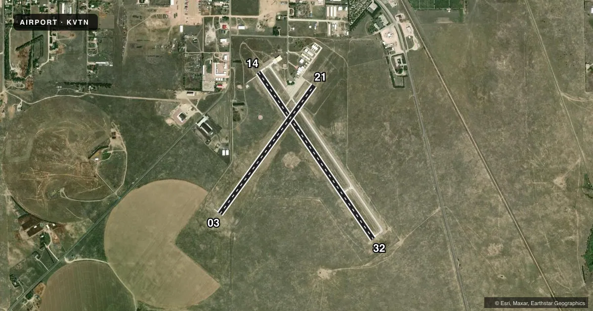
Runways & pattern
Full pagePattern entry · RWY 03
LEFT TRAFFIC| Runway | Heading (°M) | Length | Surface | Traffic |
|---|---|---|---|---|
| 14/32 | 137° / 317° | 4,705 ft | CONC | Standard L |
| 03/21Favored | 28° / 208° | 3,701 ft | CONC | Standard L |
Runway end performance
| End | TORA | TODA | ASDA | LDA | VGSI | Approach lights | Obstruction |
|---|---|---|---|---|---|---|---|
| 14 | — | — | — | — | PAPI 2-box left(3°) | — | 29', tree, 831' from thr, 310' R of cntrln, slope 21 |
| 32 | — | — | — | — | PAPI 2-box left(3°) | — | 9', fence, 395' from thr, 0' R of cntrln, slope 21 |
| 03 | — | — | — | — | PAPI 2-box left(3°) | — | — |
| 21 | — | — | — | — | PAPI 2-box left(3°) | — | — |
Declared distances in feet. TORA = takeoff run available, TODA = takeoff distance, ASDA = accelerate-stop, LDA = landing distance.
Airport sketch
Runways drawn to scale from FAA survey coordinates, rendered over satellite imagery. Not for navigation.
Approaches & charts
Services on the field
Fuel grades, oxygen, maintenance, ramp storage and lighting — as declared to the FAA by the airport operator.
Fuel & services
- Fuel
- 100LLA
- Oxygen (bottled)
- Not available
- Oxygen (bulk)
- Not available
- Airframe repair
- Minor
- Power plant repair
- Minor
- Other services
- RNTL
Ramp & ground
- Transient storage
- Tie-down
- Landing fee
- No fee published
- Customs
- Not available
- Lighting schedule
- SEE RMK
- Beacon schedule
- SS-SR
- Beacon
- White / Green (civil land)(WG)
- Wind indicator
- Lighted
- Segmented circle
- Yes
Fuel & FBOs
Cheapest 100LL and Jet A on the field and nearby. Always confirm with the FBO before taxi.
Airport notes
Surface conditions, obstructions, local procedures, lighting outages and other notes published with each FAA cycle.
General notes
- FOR CD CTC DENVER ARTCC ON FREQ. IF UNA, CTC FSS ON FREQ VIA RCO. IF UNA, CTC DENVER ARTCC AT 303-651-4257.
Lighting notes
- ACTVT REIL RWY 32; PAPI RWYS 03, 21, 14 & 32; MIRL RWYS 03/21 & 14/32 - CTAF.
Fuel notes
- 100LLFUEL AVBL 24 HRS WITH CREDIT CARD OR BY PRIOR ARRANGEMENT CALL (402) 376-2215.
Approach & departure obstructions
- 32SURVEYED
- 14RWY 14 APCH SLP 42:1 FM DTHR.
- 32RWY 32 234 FT L AT 9 FT, MEASURED.
- 32-4.4 FT AT 60 FT R; +1.4 FT ON CNTRLN; +8.5 FT AT 234 FT L.
Other notes
- OWNERCITY HALL PHONE NR.
VFR map & nearby airports
VFR sectional. Tap any ICAO chip to open that airport.
Key facts · KVTN
Answer card- ICAO
- KVTN
- Name
- MILLER FLD
- Location
- VALENTINE, NEBRASKA
- Elevation
- 2,595.4 ft MSL
- Traffic pattern altitude
- 3,595.4 ft MSL (1,000 AGL)
- Control tower
- Non-towered (use CTAF)
- Total runways
- 2
- Longest runway
- 14/32 · 4,705 ft
- Published ILS approaches
- 0
- Published frequencies
- 2
- Magnetic variation
- 8°
- Current flight rules
- VFR
- Current wind
- 080° at 15 kt
- Favored runway now
- RWY 03
Miller Fld is in Valentine, Nebraska. The field elevation is 2,595.4 ft MSL. It has two concrete runways. The longest is 4,705 ft on runway 14/32. There is no control tower. CTAF and UNICOM are both 122.8. No ILS approaches are published here.
Pattern altitude is not published, so use the standard 1,000 ft AGL for light piston operations unless the current Chart Supplement says otherwise. The on-field FBO is Sandhills Aero. It carries 100LL and Jet A Prist. Fuel is listed as available 24 hours with credit card or by prior arrangement. The published remarks also note runway lighting on both runways. PAPI is installed on 03, 21, 14 and 32. REIL is on runway 32.
This is a higher-elevation Nebraska field, so performance planning matters. The published remarks also call out terrain and obstacle effects on the approaches. Runway 14 has a steepened approach path because of trees near the displaced threshold. Runway 21 also has an obstacle on the approach path. Runway 32 has surveyed obstacle data near the runway edge. Check the current Chart Supplement before you go. Use the airport operator or the FBO directly by phone if you need current operational details.