METAR & TAF 7Q7
7Q7 does not publish a METAR.
Showing the nearest reporting station: KSUO (ROSEBUD SIOUX TRIBAL) · 18.9 NM away. Conditions at 7Q7 may differ.
METAR · KSUO
Observed 05:35Z
KSUO 270535Z AUTO 00000KT 10SM CLR 27/21 A2985 RMK AO2
- Wind
- 000° @ 0 kt
- Visibility
- 10 SM
- Temp / Dew
- 27°C / 21°C
- Altimeter
- 29.85 inHg
- Clouds
- CLR
- Density alt
- 4,194 ft
- Ceiling
- Unlimited
- Rules
- VFR
Airport info & contacts
Manager on record, flight service, ARTCC, attendance schedule and pattern altitude — published by the FAA and refreshed every 28 days.
Location
- From city
- 1 NM S
- VFR sectional
- TWIN CITIES
- ARTCC
- ZMP · MINNEAPOLIS
- NOTAM facility
- HON (NOTAM-D)
Airport manager
- Name
- JOSEPH BECHTOLD
- Phone
- 605-988-7216
- Address
- PO BOX 102, WHITE RIVER SD 57579
Flight service · Hours
- FSS HON
- HURON1-800-WX-BRIEF
- Attendance
- Unattended
Frequencies
Tap any row to copy the frequency to your clipboard.
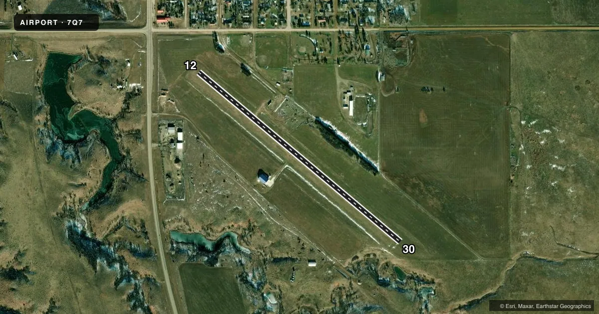
Runways & pattern
Full pagePattern entry · RWY 12
LEFT TRAFFICAirport sketch
Runways drawn to scale from FAA survey coordinates, rendered over satellite imagery. Not for navigation.
Approaches & charts
Services on the field
Fuel grades, oxygen, maintenance, ramp storage and lighting — as declared to the FAA by the airport operator.
Fuel & services
- Fuel
- Not available
- Oxygen (bottled)
- Not available
- Power plant repair
- Not available
- Other services
- AGRI
Ramp & ground
- Transient storage
- Not published
- Landing fee
- No fee published
- Customs
- Not available
- Wind indicator
- Yes
- Segmented circle
- No
Fuel & FBOs
Cheapest 100LL and Jet A on the field and nearby. Always confirm with the FBO before taxi.
Airport notes
Surface conditions, obstructions, local procedures, lighting outages and other notes published with each FAA cycle.
General notes
- WILDLIFE ON & INVOF ARPT.
- WATCH FOR HOLES MADE BY VARMINTS.
- FOR CD CTC MINNEAPOLIS ARTCC AT 651-463-5588.
- ARPT CLSD FOR NIGHT OPNS.
Approach & departure obstructions
- 12RWY 12/30 MKR WITH WHITE BLACK TIPPED MARKER CONES.
Other notes
- PRVDD RELOCATION OF THR LGTS IS PER APPLICABLE AC AND THE RESPECTIVE THRS ARE RELCTD TO PRVD A CLEAR 20:1 OVR MEN & EQUIPMENT DRG CONST OR CLOSE THE RY AND ANY CONST ON ARPT BE IN ACCORDANCE WITH AC 150/5370-2C.
VFR map & nearby airports
VFR sectional. Tap any ICAO chip to open that airport.
Key facts · 7Q7
Answer card- ICAO
- 7Q7
- Name
- WHITE RIVER MUNI
- Location
- WHITE RIVER, SOUTH DAKOTA
- Elevation
- 2,151 ft MSL
- Traffic pattern altitude
- 3,151 ft MSL (1,000 AGL)
- Control tower
- Non-towered (use CTAF)
- Total runways
- 1
- Longest runway
- 12/30 · 3,000 ft
- Published ILS approaches
- 0
- Published frequencies
- 2
- Magnetic variation
- 9°
- Current flight rules
- VFR
- Current wind
- 000° at 0 kt
- Favored runway now
- –
White River Muni sits in White River, South Dakota. Field elevation is 2,151 ft MSL. The airport has one runway. Runway 12/30 is 3,000 ft of turf, so plan for soft-field technique and check the surface before you go. The published runway headings are magnetic. No tower is on the field. CTAF and UNICOM are both 122.8. No ILS approaches are published here.
Pattern altitude is not published. Use the standard 1,000 ft AGL pattern unless the current Chart Supplement says otherwise. That puts the pattern at about 3,151 ft MSL. The airport is closed for night operations, so do not plan a night arrival or departure. Published remarks also call out wildlife on and near the airport. Varmint holes are another item to watch for on the turf. Runway 12/30 is marked with white black-tipped marker cones. There are no on-field FBOs listed. For clearance delivery, contact Minneapolis ARTCC at 651-463-5588. If you need current operational detail before a trip in, verify it with the airport operator or the current FAA Chart Supplement.